Tabas elevation
Tabas (Yazd), Iran elevation is 669 meters and Tabas elevation in feet is 2195 ft above sea level [src 1]. Tabas is a populated place (feature code) with elevation that is 375 meters (1230 ft) smaller than average city elevation in Iran.
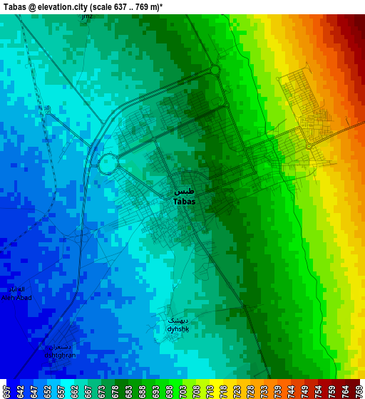
Below is the Elevation map of Tabas, which displays elevation range with different colors. Scale of the first map is from 637 to 769 m (2090 to 2523 ft) with average elevation of 678.1 meters (=2225 ft) [note 1]
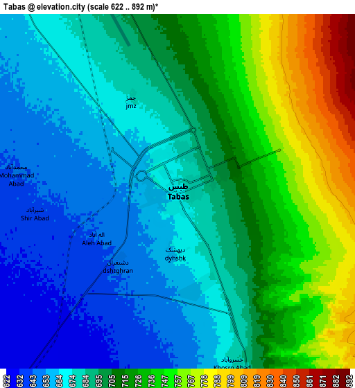
These maps also provides idea of topography and contour of this city, they are displayed at different zoom levels. More info about maps, scale and edge coordinates you can find below images.
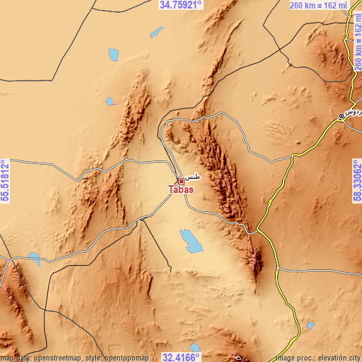
| \ | Map #1 | Map #2 | Topo.Map |
| Scale [m] | 637..769 m | 622..892 m | × |
| Scale [ft] | 2090..2523 ft | 2041..2927 ft | × |
| Average | 678.1 m = 2225 ft | 698.7 m = 2292 ft | × |
| Width | 8.14 km = 5.1 mi | 16.28 km = 10.1 mi | 260.5 km = 161.9 mi |
| Height | 8.14 km = 5.1 mi | 16.28 km = 10.1 mi | 260.5 km = 161.9 mi |
| ↑Max Latitude | 33.632457° | 33.669038° | 34.75921° |
| Latitude at center | 33.59586° | 33.59586° | 33.59586° |
| ↓Min Latitude | 33.559247° | 33.522619° | 32.4166° |
| ← Min Longitude | 56.880425° | 56.836479° | 55.51812° |
| Longitude center | 56.92437° | 56.92437° | 56.92437° |
| →Max Longitude | 56.968315° | 57.012261° | 58.33062° |
Nearby cities:
Cities around Tabas sort by population:
• Bīrjand elevation 1459 m
228.5 km,  110°
110°
• Kāshmar 1054 m
230.9 km,  37°
37°
• Gonābād 1095 m
182.8 km,  62°
62°
• Qā’en 1447 m
209.7 km,  86°
86°
• Bardaskan 990 m
208.7 km,  27°
27°
• Khalīlābād 980 m
222.7 km, 34°
• Bahābād 1404 m
209.5 km,  203°
203°
• Khūr 831 m
171.5 km,  276°
276°
• Bajestān 1259 m
154.8 km,  48°
48°
• Sarāyān 1449 m
150.6 km,  78°
78°
• Ferdows 1279 m
124.5 km,  67°
67°
• Boshrūyeh 879 m
55.6 km, 56°
Multilingual:
 En español:
Tabas elevación 669 m.
 En France:
Tabas élévation 669 m.


Sources and notes:
- [note 1] Map square and city borders are not equal. Map elevation data is calculated only from area inside that square.
- [src 1] Elevation data from geonames database provided with same terms of usage.
- [src 2] The elevation map of Tabas is generated using elevation data from NASA's 3 arcsec (90m) resolution SRTM data.
- [src 3] Base (background) map © OpenStreetMap contributors tiles are generated by Geofabrik and OpenTopoMap.
Copyright & License:
This Tabas Elevation Map is licensed under CC BY-SA. You may reuse any part from this page, if you give a proper credit by linking to this URL:
 More info on terms of use page.