Fareydūnshahr elevation
Fareydūnshahr (Isfahan), Iran elevation is 2533 meters and Fareydūnshahr elevation in feet is 8310 ft above sea level [src 1]. Fareydūnshahr is a seat of a second-order administrative division (feature code) with elevation that is 1489 meters (4885 ft) bigger than average city elevation in Iran.
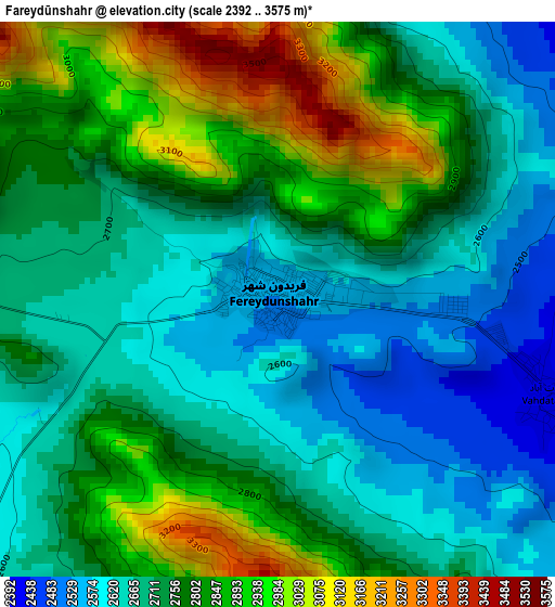
Below is the Elevation map of Fareydūnshahr, which displays elevation range with different colors. Scale of the first map is from 2392 to 3575 m (7848 to 11729 ft) with average elevation of 2750 meters (=9022 ft) [note 1]
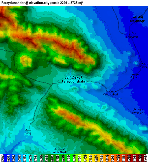
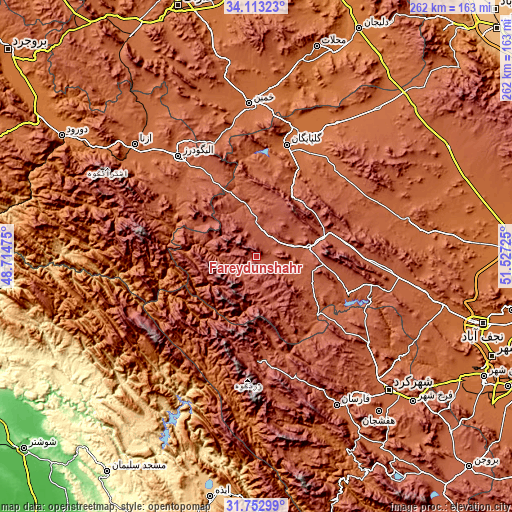
These maps also provides idea of topography and contour of this city, they are displayed at different zoom levels. More info about maps, scale and edge coordinates you can find below images.
| \ | Map #1 | Map #2 | Topo.Map |
| Scale [m] | 2392..3575 m | 2296..3735 m | × |
| Scale [ft] | 7848..11729 ft | 7533..12254 ft | × |
| Average | 2750 m = 9022 ft | 2684.7 m = 8808 ft | × |
| Width | 8.2 km = 5.1 mi | 16.4 km = 10.2 mi | 262.4 km = 163 mi |
| Height | 8.2 km = 5.1 mi | 16.4 km = 10.2 mi | 262.4 km = 163 mi |
| ↑Max Latitude | 32.977853° | 33.01471° | 34.11323° |
| Latitude at center | 32.94098° | 32.94098° | 32.94098° |
| ↓Min Latitude | 32.904092° | 32.867189° | 31.75299° |
| ← Min Longitude | 50.077055° | 50.033109° | 48.71475° |
| Longitude center | 50.121° | 50.121° | 50.121° |
| →Max Longitude | 50.164945° | 50.208891° | 51.52725° |
Nearby cities:
Cities around Fareydūnshahr sort by population:
• Shahr-e Kord elevation 2074 m
97.1 km,  134°
134°
• Alīgūdarz 1985 m
65.2 km,  322°
322°
• Khomeyn 1788 m
77.7 km,  357°
357°
• Golpāyegān 1817 m
59.1 km,  15°
15°
• Fārsān 2039 m
86.5 km,  151°
151°
• Khvānsār 2230 m
36 km,  30°
30°
• Qal‘eh-ye Khvājeh 753 m
103.4 km,  217°
217°
• Tīrān 1837 m
100.1 km,  105°
105°
• Aznā 1862 m
84.3 km,  312°
312°
• Chelgard 2331 m
52.7 km,  179°
179°
• Chādegān 2113 m
51.2 km, 112°
• Dārān 2315 m
27.7 km,  78°
78°
Multilingual:
 En español:
Fareydūnshahr elevación 2533 m.
 En France:
Fareydūnshahr élévation 2533 m.
 Auf Deutsch:
Fareydūnshahr höhe über dem Meeresspiegel ist 2533 m.

Sources and notes:
- [note 1] Map square and city borders are not equal. Map elevation data is calculated only from area inside that square.
- [src 1] Elevation data from geonames database provided with same terms of usage.
- [src 2] The elevation map of Fareydūnshahr is generated using elevation data from NASA's 3 arcsec (90m) resolution SRTM data.
- [src 3] Base (background) map © OpenStreetMap contributors tiles are generated by Geofabrik and OpenTopoMap.
Copyright & License:
This Fareydūnshahr Elevation Map is licensed under CC BY-SA. You may reuse any part from this page, if you give a proper credit by linking to this URL:
 More info on terms of use page.