Fārsān elevation
Fārsān (Chaharmahal and Bakhtiari), Iran elevation is 2039 meters and Fārsān elevation in feet is 6690 ft above sea level [src 1]. Fārsān is a seat of a second-order administrative division (feature code) with elevation that is 995 meters (3264 ft) bigger than average city elevation in Iran.
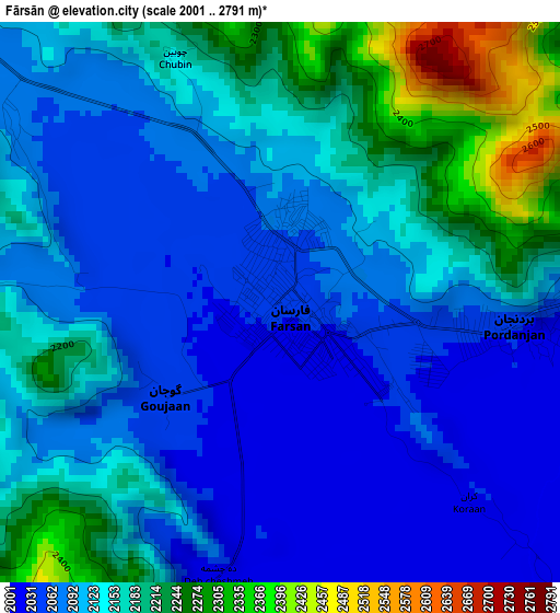
Below is the Elevation map of Fārsān, which displays elevation range with different colors. Scale of the first map is from 2001 to 2791 m (6565 to 9157 ft) with average elevation of 2128 meters (=6982 ft) [note 1]
These maps also provides idea of topography and contour of this city, they are displayed at different zoom levels. More info about maps, scale and edge coordinates you can find below images.
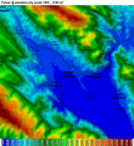
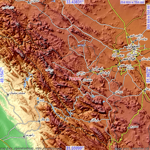
| \ | Map #1 | Map #2 | Topo.Map |
| Scale [m] | 2001..2791 m | 1992..3188 m | × |
| Scale [ft] | 6565..9157 ft | 6535..10459 ft | × |
| Average | 2128 m = 6982 ft | 2296.1 m = 7533 ft | × |
| Width | 8.26 km = 5.1 mi | 16.53 km = 10.3 mi | 264.4 km = 164.3 mi |
| Height | 8.26 km = 5.1 mi | 16.53 km = 10.3 mi | 264.4 km = 164.3 mi |
| ↑Max Latitude | 32.294095° | 32.331235° | 33.43831° |
| Latitude at center | 32.25694° | 32.25694° | 32.25694° |
| ↓Min Latitude | 32.219769° | 32.182584° | 31.05999° |
| ← Min Longitude | 50.517005° | 50.473059° | 49.1547° |
| Longitude center | 50.56095° | 50.56095° | 50.56095° |
| →Max Longitude | 50.604895° | 50.648841° | 51.9672° |
Nearby cities:
Cities around Fārsān sort by population:
• Najafābād elevation 1649 m
86.5 km,  60°
60°
• Shahr-e Kord 2074 m
28.9 km,  74°
74°
• Borūjen 2230 m
75.7 km,  115°
115°
• Farrokh Shahr 2106 m
39.4 km,  87°
87°
• Lordegān 1588 m
86.4 km,  163°
163°
• Dārān 2315 m
82.5 km,  350°
350°
• Zarrīn Shahr 1705 m
78 km,  79°
79°
• Tīrān 1837 m
74.5 km,  48°
48°
• Chādegān 2113 m
57.2 km,  6°
6°
• Chelgard 2331 m
47.4 km,  299°
299°
• Shalamzār 2016 m
33.6 km,  134°
134°
• Ardal 1860 m
30.2 km, 161°
Multilingual:
 En español:
Fārsān elevación 2039 m.
 En France:
Fārsān élévation 2039 m.


Sources and notes:
- [note 1] Map square and city borders are not equal. Map elevation data is calculated only from area inside that square.
- [src 1] Elevation data from geonames database provided with same terms of usage.
- [src 2] The elevation map of Fārsān is generated using elevation data from NASA's 3 arcsec (90m) resolution SRTM data.
- [src 3] Base (background) map © OpenStreetMap contributors tiles are generated by Geofabrik and OpenTopoMap.
Copyright & License:
This Fārsān Elevation Map is licensed under CC BY-SA. You may reuse any part from this page, if you give a proper credit by linking to this URL:
 More info on terms of use page.