Golpāyegān elevation
Golpāyegān (Isfahan), Iran elevation is 1817 meters and Golpāyegān elevation in feet is 5961 ft above sea level [src 1]. Golpāyegān is a seat of a second-order administrative division (feature code) with elevation that is 773 meters (2536 ft) bigger than average city elevation in Iran.
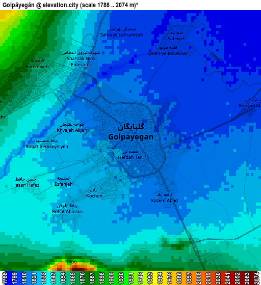
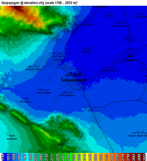
Below is the Elevation map of Golpāyegān, which displays elevation range with different colors. Scale of the first map is from 1788 to 2074 m (5866 to 6804 ft) with average elevation of 1829 meters (=6001 ft) [note 1]
These maps also provides idea of topography and contour of this city, they are displayed at different zoom levels. More info about maps, scale and edge coordinates you can find below images.
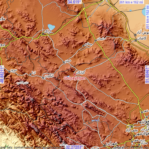
| \ | Map #1 | Map #2 | Topo.Map |
| Scale [m] | 1788..2074 m | 1768..2933 m | × |
| Scale [ft] | 5866..6804 ft | 5801..9623 ft | × |
| Average | 1829 m = 6001 ft | 1927.5 m = 6324 ft | × |
| Width | 8.15 km = 5.1 mi | 16.31 km = 10.1 mi | 260.9 km = 162.1 mi |
| Height | 8.15 km = 5.1 mi | 16.31 km = 10.1 mi | 260.9 km = 162.1 mi |
| ↑Max Latitude | 33.490357° | 33.526999° | 34.619° |
| Latitude at center | 33.4537° | 33.4537° | 33.4537° |
| ↓Min Latitude | 33.417027° | 33.380339° | 32.27253° |
| ← Min Longitude | 50.244415° | 50.200469° | 48.88211° |
| Longitude center | 50.28836° | 50.28836° | 50.28836° |
| →Max Longitude | 50.332305° | 50.376251° | 51.69461° |
Nearby cities:
Cities around Golpāyegān sort by population:
• Arāk elevation 1728 m
89.8 km,  322°
322°
• Alīgūdarz 1985 m
55.6 km,  264°
264°
• Khomeyn 1788 m
28.2 km, 316°
• Delījān 1522 m
70 km,  31°
31°
• Khvānsār 2230 m
26 km,  174°
174°
• Fareydūnshahr 2533 m
59.1 km,  195°
195°
• Chelgard 2331 m
110.8 km,  188°
188°
• Shāzand 1906 m
97.4 km,  303°
303°
• Chādegān 2113 m
82.5 km,  157°
157°
• Aznā 1862 m
77.2 km,  270°
270°
• Maḩallāt 1751 m
53.1 km,  16°
16°
• Dārān 2315 m
53 km, 167°
Multilingual:
 En español:
Golpāyegān elevación 1817 m.
 En France:
Golpāyegān élévation 1817 m.
 Auf Deutsch:
Golpāyegān höhe über dem Meeresspiegel ist 1817 m.

Sources and notes:
- [note 1] Map square and city borders are not equal. Map elevation data is calculated only from area inside that square.
- [src 1] Elevation data from geonames database provided with same terms of usage.
- [src 2] The elevation map of Golpāyegān is generated using elevation data from NASA's 3 arcsec (90m) resolution SRTM data.
- [src 3] Base (background) map © OpenStreetMap contributors tiles are generated by Geofabrik and OpenTopoMap.
Copyright & License:
This Golpāyegān Elevation Map is licensed under CC BY-SA. You may reuse any part from this page, if you give a proper credit by linking to this URL:
 More info on terms of use page.