Delījān elevation
Delījān (Markazi), Iran elevation is 1522 meters and Delījān elevation in feet is 4993 ft above sea level [src 1]. Delījān is a seat of a second-order administrative division (feature code) with elevation that is 478 meters (1568 ft) bigger than average city elevation in Iran.
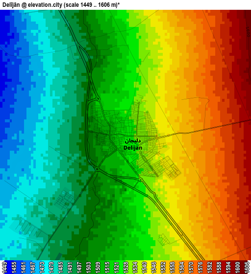
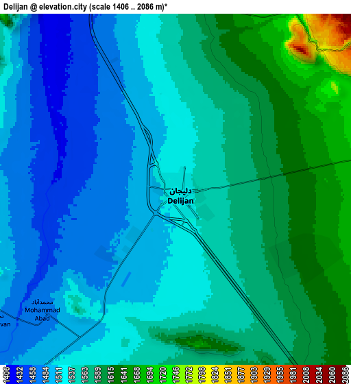
Below is the Elevation map of Delījān, which displays elevation range with different colors. Scale of the first map is from 1449 to 1606 m (4754 to 5269 ft) with average elevation of 1522.3 meters (=4994 ft) [note 1]
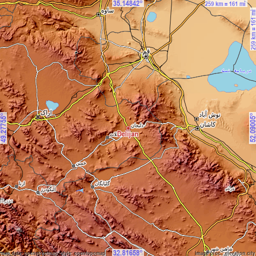
These maps also provides idea of topography and contour of this city, they are displayed at different zoom levels. More info about maps, scale and edge coordinates you can find below images.
| \ | Map #1 | Map #2 | Topo.Map |
| Scale [m] | 1449..1606 m | 1406..2086 m | × |
| Scale [ft] | 4754..5269 ft | 4613..6844 ft | × |
| Average | 1522.3 m = 4994 ft | 1549.7 m = 5084 ft | × |
| Width | 8.1 km = 5 mi | 16.21 km = 10.1 mi | 259.3 km = 161.1 mi |
| Height | 8.1 km = 5 mi | 16.21 km = 10.1 mi | 259.3 km = 161.1 mi |
| ↑Max Latitude | 34.026929° | 34.063342° | 35.14842° |
| Latitude at center | 33.9905° | 33.9905° | 33.9905° |
| ↓Min Latitude | 33.954056° | 33.917596° | 32.81658° |
| ← Min Longitude | 50.639855° | 50.595909° | 49.27755° |
| Longitude center | 50.6838° | 50.6838° | 50.6838° |
| →Max Longitude | 50.727745° | 50.771691° | 52.09005° |
Nearby cities:
Cities around Delījān sort by population:
• Qom elevation 935 m
74.4 km,  13°
13°
• Arāk 1728 m
91.6 km,  277°
277°
• Alīgūdarz 1985 m
112.6 km,  234°
234°
• Khomeyn 1788 m
68.1 km, 234°
• Golpāyegān 1817 m
70 km,  211°
211°
• Khvānsār 2230 m
92.2 km,  201°
201°
• Tafresh 1910 m
99.3 km,  321°
321°
• Farmahīn 1782 m
108.1 km,  301°
301°
• Āshtīān 2073 m
85.9 km,  313°
313°
• Ārān Bīdgol 909 m
74 km,  84°
84°
• Kāshān 936 m
69.9 km,  89°
89°
• Maḩallāt 1751 m
23 km,  247°
247°
Multilingual:
 En español:
Delījān elevación 1522 m.
 En France:
Delījān élévation 1522 m.
 Auf Deutsch:
Delījān höhe über dem Meeresspiegel ist 1522 m.

Sources and notes:
- [note 1] Map square and city borders are not equal. Map elevation data is calculated only from area inside that square.
- [src 1] Elevation data from geonames database provided with same terms of usage.
- [src 2] The elevation map of Delījān is generated using elevation data from NASA's 3 arcsec (90m) resolution SRTM data.
- [src 3] Base (background) map © OpenStreetMap contributors tiles are generated by Geofabrik and OpenTopoMap.
Copyright & License:
This Delījān Elevation Map is licensed under CC BY-SA. You may reuse any part from this page, if you give a proper credit by linking to this URL:
 More info on terms of use page.