Mehrān elevation
Mehrān (Ilam Province), Iran elevation is 150 meters and Mehrān elevation in feet is 492 ft above sea level [src 1]. Mehrān is a seat of a second-order administrative division (feature code) with elevation that is 894 meters (2933 ft) smaller than average city elevation in Iran.
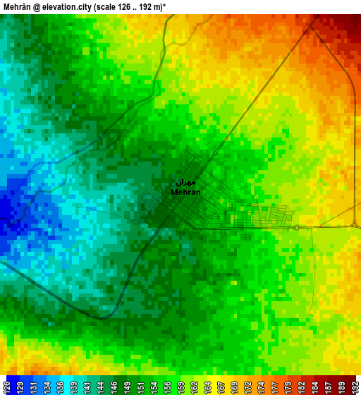
Below is the Elevation map of Mehrān, which displays elevation range with different colors. Scale of the first map is from 126 to 192 m (413 to 630 ft) with average elevation of 155.2 meters (=509 ft) [note 1]
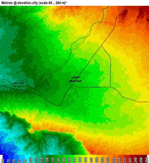
These maps also provides idea of topography and contour of this city, they are displayed at different zoom levels. More info about maps, scale and edge coordinates you can find below images.
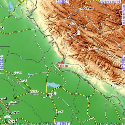
| \ | Map #1 | Map #2 | Topo.Map |
| Scale [m] | 126..192 m | 64..264 m | × |
| Scale [ft] | 413..630 ft | 210..866 ft | × |
| Average | 155.2 m = 509 ft | 163.1 m = 535 ft | × |
| Width | 8.18 km = 5.1 mi | 16.37 km = 10.2 mi | 261.9 km = 162.7 mi |
| Height | 8.18 km = 5.1 mi | 16.37 km = 10.2 mi | 261.9 km = 162.7 mi |
| ↑Max Latitude | 33.158997° | 33.195778° | 34.292° |
| Latitude at center | 33.1222° | 33.1222° | 33.1222° |
| ↓Min Latitude | 33.085388° | 33.04856° | 31.93661° |
| ← Min Longitude | 46.120655° | 46.076709° | 44.75835° |
| Longitude center | 46.1646° | 46.1646° | 46.1646° |
| →Max Longitude | 46.208545° | 46.252491° | 47.57085° |
Nearby cities:
Cities around Mehrān sort by population:
• Īlām elevation 1403 m
62.1 km,  22°
22°
• Kūhdasht 1190 m
141.8 km,  71°
71°
• Dehlorān 224 m
113.5 km,  114°
114°
• Darreh Shahr 660 m
113.2 km,  88°
88°
• Ābdānān 889 m
117.9 km,  97°
97°
• Poldokhtar 663 m
143.9 km, 88°
• Kerend-e Gharb 1588 m
129.4 km,  3°
3°
• Gīlān-e Gharb 802 m
115.6 km,  348°
348°
• Eslāmābād-e Gharb 1332 m
114.8 km, 17°
• Sarābleh 1027 m
80.9 km,  27°
27°
• Eyvān 1184 m
79.5 km,  9°
9°
• Arakvāz-e Malekshāhī 1326 m
49.7 km,  54°
54°
Multilingual:
 En español:
Mehrān elevación 150 m.
 En France:
Mehrān élévation 150 m.


Sources and notes:
- [note 1] Map square and city borders are not equal. Map elevation data is calculated only from area inside that square.
- [src 1] Elevation data from geonames database provided with same terms of usage.
- [src 2] The elevation map of Mehrān is generated using elevation data from NASA's 3 arcsec (90m) resolution SRTM data.
- [src 3] Base (background) map © OpenStreetMap contributors tiles are generated by Geofabrik and OpenTopoMap.
Copyright & License:
This Mehrān Elevation Map is licensed under CC BY-SA. You may reuse any part from this page, if you give a proper credit by linking to this URL:
 More info on terms of use page.