Neyrīz elevation
Neyrīz (Fars), Iran elevation is 1606 meters and Neyrīz elevation in feet is 5269 ft above sea level [src 1]. Neyrīz is a seat of a second-order administrative division (feature code) with elevation that is 562 meters (1844 ft) bigger than average city elevation in Iran.
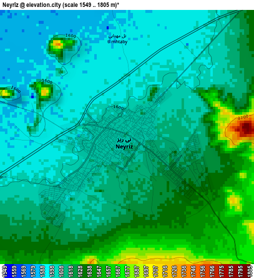
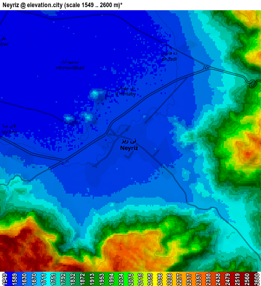
Below is the Elevation map of Neyrīz, which displays elevation range with different colors. Scale of the first map is from 1549 to 1805 m (5082 to 5922 ft) with average elevation of 1617.1 meters (=5305 ft) [note 1]
These maps also provides idea of topography and contour of this city, they are displayed at different zoom levels. More info about maps, scale and edge coordinates you can find below images.
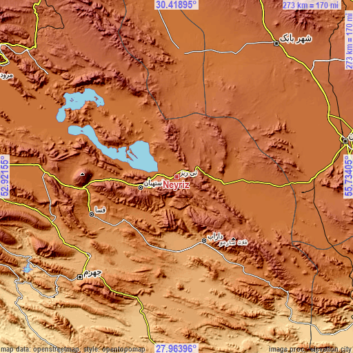
| \ | Map #1 | Map #2 | Topo.Map |
| Scale [m] | 1549..1805 m | 1549..2600 m | × |
| Scale [ft] | 5082..5922 ft | 5082..8530 ft | × |
| Average | 1617.1 m = 5305 ft | 1757.4 m = 5766 ft | × |
| Width | 8.53 km = 5.3 mi | 17.06 km = 10.6 mi | 273 km = 169.6 mi |
| Height | 8.53 km = 5.3 mi | 17.06 km = 10.6 mi | 273 km = 169.6 mi |
| ↑Max Latitude | 29.237154° | 29.275494° | 30.41895° |
| Latitude at center | 29.1988° | 29.1988° | 29.1988° |
| ↓Min Latitude | 29.160432° | 29.122049° | 27.96396° |
| ← Min Longitude | 54.283855° | 54.239909° | 52.92155° |
| Longitude center | 54.3278° | 54.3278° | 54.3278° |
| →Max Longitude | 54.371745° | 54.415691° | 55.73405° |
Nearby cities:
Cities around Neyrīz sort by population:
• Sirjan elevation 1744 m
134.1 km,  77°
77°
• Fasā 1366 m
72.1 km,  246°
246°
• Dārāb 1131 m
54 km,  157°
157°
• Shahr-e Bābak 1846 m
127.5 km,  36°
36°
• Qīr 774 m
149 km,  237°
237°
• Arsanjān 1634 m
126.5 km,  308°
308°
• Sarvestān 1542 m
107.8 km,  274°
274°
• Jahrom 1040 m
107.8 km,  223°
223°
• Kherāmeh 1593 m
104 km,  288°
288°
• Shahr-e Herāt 1595 m
95.2 km,  2°
2°
• Ḩājjīābād 1033 m
94 km,  174°
174°
• Estahbān 1743 m
28.9 km, 253°
Multilingual:
 En español:
Neyrīz elevación 1606 m.
 En France:
Neyrīz élévation 1606 m.


Sources and notes:
- [note 1] Map square and city borders are not equal. Map elevation data is calculated only from area inside that square.
- [src 1] Elevation data from geonames database provided with same terms of usage.
- [src 2] The elevation map of Neyrīz is generated using elevation data from NASA's 3 arcsec (90m) resolution SRTM data.
- [src 3] Base (background) map © OpenStreetMap contributors tiles are generated by Geofabrik and OpenTopoMap.
Copyright & License:
This Neyrīz Elevation Map is licensed under CC BY-SA. You may reuse any part from this page, if you give a proper credit by linking to this URL:
 More info on terms of use page.