Dārāb elevation
Dārāb (Fars), Iran elevation is 1131 meters and Dārāb elevation in feet is 3711 ft above sea level [src 1]. Dārāb is a seat of a second-order administrative division (feature code) with elevation that is 87 meters (285 ft) bigger than average city elevation in Iran.
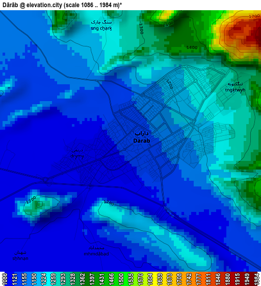
Below is the Elevation map of Dārāb, which displays elevation range with different colors. Scale of the first map is from 1086 to 1984 m (3563 to 6509 ft) with average elevation of 1201.3 meters (=3941 ft) [note 1]
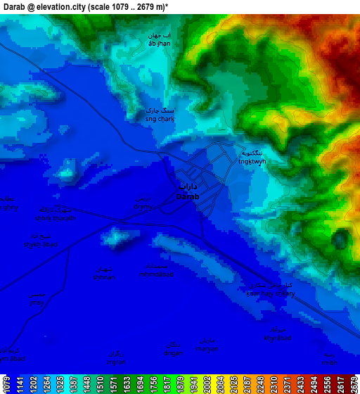
These maps also provides idea of topography and contour of this city, they are displayed at different zoom levels. More info about maps, scale and edge coordinates you can find below images.
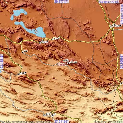
| \ | Map #1 | Map #2 | Topo.Map |
| Scale [m] | 1086..1984 m | 1079..2679 m | × |
| Scale [ft] | 3563..6509 ft | 3540..8789 ft | × |
| Average | 1201.3 m = 3941 ft | 1343.8 m = 4409 ft | × |
| Width | 8.57 km = 5.3 mi | 17.14 km = 10.7 mi | 274.2 km = 170.4 mi |
| Height | 8.57 km = 5.3 mi | 17.14 km = 10.7 mi | 274.2 km = 170.4 mi |
| ↑Max Latitude | 28.79046° | 28.828966° | 29.97747° |
| Latitude at center | 28.75194° | 28.75194° | 28.75194° |
| ↓Min Latitude | 28.713406° | 28.674857° | 27.51186° |
| ← Min Longitude | 54.500495° | 54.456549° | 53.13819° |
| Longitude center | 54.54444° | 54.54444° | 54.54444° |
| →Max Longitude | 54.588385° | 54.632331° | 55.95069° |
Nearby cities:
Cities around Dārāb sort by population:
• Sirjan elevation 1744 m
135 km,  54°
54°
• Fasā 1366 m
89.7 km,  283°
283°
• Neyrīz 1606 m
54 km,  337°
337°
• Gerāsh 923 m
126.8 km,  198°
198°
• Kherāmeh 1593 m
145.7 km,  304°
304°
• Khonj 671 m
144.8 km,  228°
228°
• Ḩājjīābād 926 m
141.4 km,  110°
110°
• Sarvestān 1542 m
141.2 km,  294°
294°
• Shahr-e Qadīm-e Lār 818 m
120.5 km,  189°
189°
• Jahrom 1040 m
100 km,  253°
253°
• Estahbān 1743 m
64.2 km,  310°
310°
• Ḩājjīābād 1033 m
45.4 km, 195°
Multilingual:
 En español:
Dārāb elevación 1131 m.
 En France:
Dārāb élévation 1131 m.


Sources and notes:
- [note 1] Map square and city borders are not equal. Map elevation data is calculated only from area inside that square.
- [src 1] Elevation data from geonames database provided with same terms of usage.
- [src 2] The elevation map of Dārāb is generated using elevation data from NASA's 3 arcsec (90m) resolution SRTM data.
- [src 3] Base (background) map © OpenStreetMap contributors tiles are generated by Geofabrik and OpenTopoMap.
Copyright & License:
This Dārāb Elevation Map is licensed under CC BY-SA. You may reuse any part from this page, if you give a proper credit by linking to this URL:
 More info on terms of use page.