Shahr-e Bābak elevation
Shahr-e Bābak (Kerman), Iran elevation is 1846 meters and Shahr-e Bābak elevation in feet is 6056 ft above sea level [src 1]. Shahr-e Bābak is a seat of a second-order administrative division (feature code) with elevation that is 802 meters (2631 ft) bigger than average city elevation in Iran.
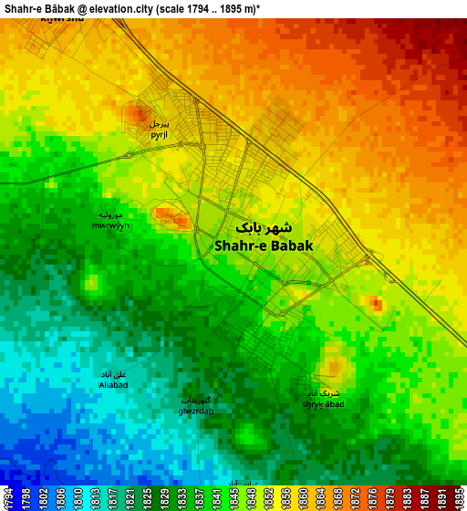
Below is the Elevation map of Shahr-e Bābak, which displays elevation range with different colors. Scale of the first map is from 1794 to 1895 m (5886 to 6217 ft) with average elevation of 1844.5 meters (=6052 ft) [note 1]
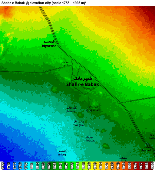
These maps also provides idea of topography and contour of this city, they are displayed at different zoom levels. More info about maps, scale and edge coordinates you can find below images.
| \ | Map #1 | Map #2 | Topo.Map |
| Scale [m] | 1794..1895 m | 1755..1995 m | × |
| Scale [ft] | 5886..6217 ft | 5758..6545 ft | × |
| Average | 1844.5 m = 6052 ft | 1851.3 m = 6074 ft | × |
| Width | 8.45 km = 5.3 mi | 16.91 km = 10.5 mi | 270.5 km = 168.1 mi |
| Height | 8.45 km = 5.3 mi | 16.91 km = 10.5 mi | 270.5 km = 168.1 mi |
| ↑Max Latitude | 30.154506° | 30.192497° | 31.32537° |
| Latitude at center | 30.1165° | 30.1165° | 30.1165° |
| ↓Min Latitude | 30.07848° | 30.040445° | 28.89266° |
| ← Min Longitude | 55.074655° | 55.030709° | 53.71235° |
| Longitude center | 55.1186° | 55.1186° | 55.1186° |
| →Max Longitude | 55.162545° | 55.206491° | 56.52485° |
Nearby cities:
Cities around Shahr-e Bābak sort by population:
• Sirjan elevation 1744 m
91.7 km,  143°
143°
• Rafsanjān 1514 m
90 km,  69°
69°
• Dārāb 1131 m
161.6 km,  200°
200°
• Zarand 1656 m
158.7 km,  60°
60°
• Neyrīz 1606 m
127.5 km,  216°
216°
• Bardsīr 2049 m
141.8 km,  98°
98°
• Bāfq 991 m
167.5 km,  9°
9°
• Shahrak-e Pābedānā 2117 m
166.7 km,  47°
47°
• Estahbān 1743 m
151.5 km, 223°
• Sūrīān 2182 m
145.9 km,  284°
284°
• Anār 1409 m
85.1 km, 9°
• Shahr-e Herāt 1595 m
72.1 km,  264°
264°
Multilingual:
 En español:
Shahr-e Bābak elevación 1846 m.
 En France:
Shahr-e Bābak élévation 1846 m.
 Auf Deutsch:
Shahr-e Bābak höhe über dem Meeresspiegel ist 1846 m.

Sources and notes:
- [note 1] Map square and city borders are not equal. Map elevation data is calculated only from area inside that square.
- [src 1] Elevation data from geonames database provided with same terms of usage.
- [src 2] The elevation map of Shahr-e Bābak is generated using elevation data from NASA's 3 arcsec (90m) resolution SRTM data.
- [src 3] Base (background) map © OpenStreetMap contributors tiles are generated by Geofabrik and OpenTopoMap.
Copyright & License:
This Shahr-e Bābak Elevation Map is licensed under CC BY-SA. You may reuse any part from this page, if you give a proper credit by linking to this URL:
 More info on terms of use page.