Ar Ruţbah elevation
Ar Ruţbah (Anbar, Al-Rutba District), Iraq elevation is 620 meters and Ar Ruţbah elevation in feet is 2034 ft above sea level [src 1]. Ar Ruţbah is a seat of a second-order administrative division (feature code) with elevation that is 327 meters (1073 ft) bigger than average city elevation in Iraq.
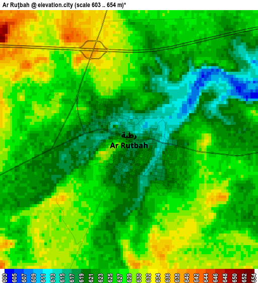
Below is the Elevation map of Ar Ruţbah, which displays elevation range with different colors. Scale of the first map is from 603 to 654 m (1978 to 2146 ft) with average elevation of 625.4 meters (=2052 ft) [note 1]
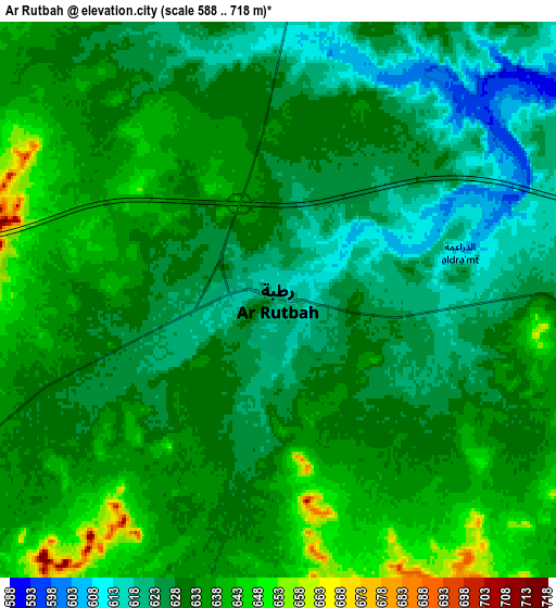
These maps also provides idea of topography and contour of this city, they are displayed at different zoom levels. More info about maps, scale and edge coordinates you can find below images.
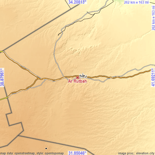
| \ | Map #1 | Map #2 | Topo.Map |
| Scale [m] | 603..654 m | 588..718 m | × |
| Scale [ft] | 1978..2146 ft | 1929..2356 ft | × |
| Average | 625.4 m = 2052 ft | 630.3 m = 2068 ft | × |
| Width | 8.19 km = 5.1 mi | 16.39 km = 10.2 mi | 262.1 km = 162.9 mi |
| Height | 8.19 km = 5.1 mi | 16.38 km = 10.2 mi | 262.2 km = 162.9 mi |
| ↑Max Latitude | 33.074012° | 33.110829° | 34.20813° |
| Latitude at center | 33.03718° | 33.03718° | 33.03718° |
| ↓Min Latitude | 33.000332° | 32.963469° | 31.85046° |
| ← Min Longitude | 40.241915° | 40.197969° | 38.87961° |
| Longitude center | 40.28586° | 40.28586° | 40.28586° |
| →Max Longitude | 40.329805° | 40.373751° | 41.69211° |
Nearby cities:
Cities around Ar Ruţbah sort by population:
• Karbala elevation 32 m
352.5 km,  97°
97°
• Ramadi 53 m
284.3 km,  81°
81°
• Al Fallūjah 45 m
327.5 km, 83°
• Sāmarrā’ 80 m
357.3 km,  68°
68°
• Hīt 61 m
245.3 km, 74°
• Ḩadīthah 121 m
229.1 km,  57°
57°
• ‘Anah 177 m
215.7 km,  46°
46°
• ‘Anat al Qadīmah 171 m
220.9 km,  43°
43°
• Rāwah 186 m
220.5 km, 43°
• ‘Ayn Tamr 66 m
303.8 km, 99°
• Al Ḩaqlānīyah 126 m
224.9 km, 58°
• Al Qā’im 180 m
164.1 km,  23°
23°
Multilingual:
 En español:
Ar Ruţbah elevación 620 m.
 En France:
Ar Ruţbah élévation 620 m.
 Auf Deutsch:
Ar Ruţbah höhe über dem Meeresspiegel ist 620 m.

Sources and notes:
- [note 1] Map square and city borders are not equal. Map elevation data is calculated only from area inside that square.
- [src 1] Elevation data from geonames database provided with same terms of usage.
- [src 2] The elevation map of Ar Ruţbah is generated using elevation data from NASA's 3 arcsec (90m) resolution SRTM data.
- [src 3] Base (background) map © OpenStreetMap contributors tiles are generated by Geofabrik and OpenTopoMap.
Copyright & License:
This Ar Ruţbah Elevation Map is licensed under CC BY-SA. You may reuse any part from this page, if you give a proper credit by linking to this URL:
 More info on terms of use page.