Sāmarrā’ elevation
Sāmarrā’ (Salah ad Din, Al-Daur District), Iraq elevation is 80 meters and Sāmarrā’ elevation in feet is 262 ft above sea level [src 1]. Sāmarrā’ is a seat of a second-order administrative division (feature code) with elevation that is 213 meters (699 ft) smaller than average city elevation in Iraq.
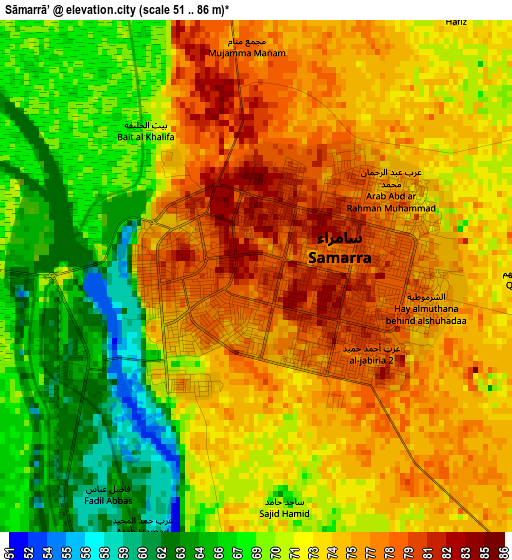
Below is the Elevation map of Sāmarrā’, which displays elevation range with different colors. Scale of the first map is from 51 to 86 m (167 to 282 ft) with average elevation of 72.3 meters (=237 ft) [note 1]
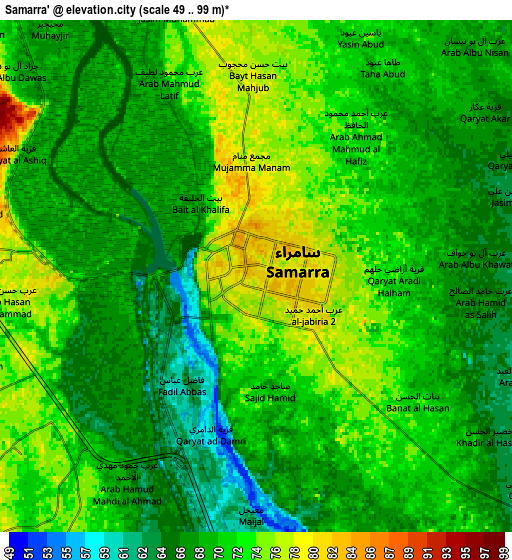
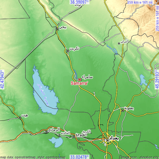
These maps also provides idea of topography and contour of this city, they are displayed at different zoom levels. More info about maps, scale and edge coordinates you can find below images.
| \ | Map #1 | Map #2 | Topo.Map |
| Scale [m] | 51..86 m | 49..99 m | × |
| Scale [ft] | 167..282 ft | 161..325 ft | × |
| Average | 72.3 m = 237 ft | 70.2 m = 230 ft | × |
| Width | 8.08 km = 5 mi | 16.17 km = 10 mi | 258.6 km = 160.7 mi |
| Height | 8.08 km = 5 mi | 16.17 km = 10 mi | 258.6 km = 160.7 mi |
| ↑Max Latitude | 34.23224° | 34.268565° | 35.35097° |
| Latitude at center | 34.1959° | 34.1959° | 34.1959° |
| ↓Min Latitude | 34.159544° | 34.123173° | 33.02478° |
| ← Min Longitude | 43.841735° | 43.797789° | 42.47943° |
| Longitude center | 43.88568° | 43.88568° | 43.88568° |
| →Max Longitude | 43.929625° | 43.973571° | 45.29193° |
Nearby cities:
Cities around Sāmarrā’ sort by population:
• Al Fallūjah elevation 45 m
94.6 km,  185°
185°
• Baqubah 48 m
82.6 km,  126°
126°
• Khāliş 43 m
73.7 km, 125°
• Al Miqdādīyah 60 m
99.8 km,  104°
104°
• Tikrīt 112 m
50.4 km,  337°
337°
• Balad 53 m
31.3 km, 130°
• Bayjī 115 m
89.3 km, 335°
• Ad Dujayl 46 m
50.4 km,  140°
140°
• Aţ Ţārmīyah 41 m
74.7 km, 140°
• Al Khāliş 49 m
69.9 km,  123°
123°
• Al ‘Awjah 77 m
40 km, 339°
• Ad Dawr 93 m
30.1 km, 343°
Multilingual:
 En español:
Sāmarrā’ elevación 80 m.
 En France:
Sāmarrā’ élévation 80 m.


Sources and notes:
- [note 1] Map square and city borders are not equal. Map elevation data is calculated only from area inside that square.
- [src 1] Elevation data from geonames database provided with same terms of usage.
- [src 2] The elevation map of Sāmarrā’ is generated using elevation data from NASA's 3 arcsec (90m) resolution SRTM data.
- [src 3] Base (background) map © OpenStreetMap contributors tiles are generated by Geofabrik and OpenTopoMap.
Copyright & License:
This Sāmarrā’ Elevation Map is licensed under CC BY-SA. You may reuse any part from this page, if you give a proper credit by linking to this URL:
 More info on terms of use page.