Bayjī elevation
Bayjī (Salah ad Din, Baiji District), Iraq elevation is 115 meters and Bayjī elevation in feet is 377 ft above sea level [src 1]. Bayjī is a seat of a second-order administrative division (feature code) with elevation that is 178 meters (584 ft) smaller than average city elevation in Iraq.
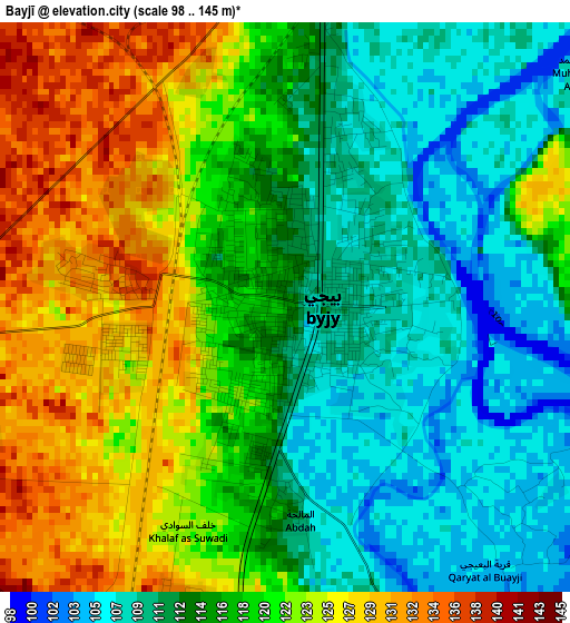
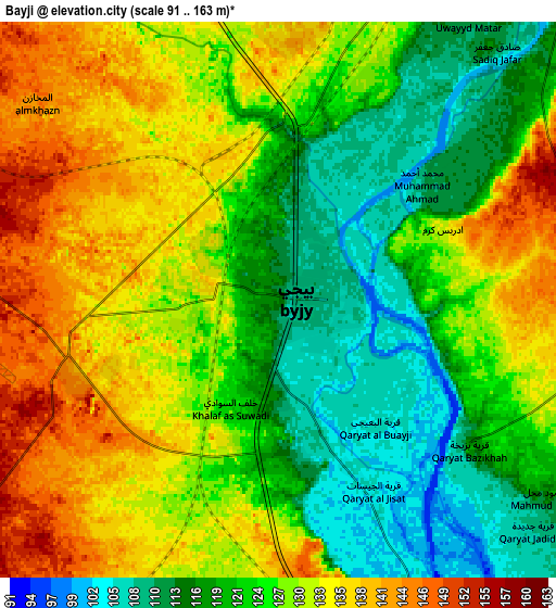
Below is the Elevation map of Bayjī, which displays elevation range with different colors. Scale of the first map is from 98 to 145 m (322 to 476 ft) with average elevation of 117.5 meters (=385 ft) [note 1]
These maps also provides idea of topography and contour of this city, they are displayed at different zoom levels. More info about maps, scale and edge coordinates you can find below images.
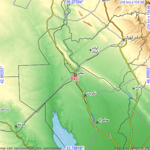
| \ | Map #1 | Map #2 | Topo.Map |
| Scale [m] | 98..145 m | 91..163 m | × |
| Scale [ft] | 322..476 ft | 299..535 ft | × |
| Average | 117.5 m = 385 ft | 126.2 m = 414 ft | × |
| Width | 8.01 km = 5 mi | 16.02 km = 10 mi | 256.4 km = 159.3 mi |
| Height | 8.01 km = 5 mi | 16.02 km = 10 mi | 256.4 km = 159.3 mi |
| ↑Max Latitude | 34.965171° | 35.001176° | 36.07394° |
| Latitude at center | 34.92915° | 34.92915° | 34.92915° |
| ↓Min Latitude | 34.893113° | 34.85706° | 33.76816° |
| ← Min Longitude | 43.444835° | 43.400889° | 42.08253° |
| Longitude center | 43.48878° | 43.48878° | 43.48878° |
| →Max Longitude | 43.532725° | 43.576671° | 44.89503° |
Nearby cities:
Cities around Bayjī sort by population:
• Sāmarrā’ elevation 80 m
89.3 km,  155°
155°
• Tikrīt 112 m
38.9 km,  153°
153°
• Al Qayyārah 183 m
98.3 km,  349°
349°
• Dibis 242 m
98.3 km,  32°
32°
• Mexmur 266 m
94.5 km,  5°
5°
• Dāqūq 227 m
90.5 km,  75°
75°
• Ash Sharqāt 159 m
69.5 km,  340°
340°
• Ad Dawr 93 m
59.5 km, 152°
• Ar Riyāḑ 189 m
53.9 km,  45°
45°
• Al Ḩawījah 192 m
51.1 km, 30°
• Al ‘Awjah 77 m
49.4 km, 153°
• Al ‘Abbāsī 174 m
39.7 km, 14°
Multilingual:
 En español:
Bayjī elevación 115 m.
 En France:
Bayjī élévation 115 m.


Sources and notes:
- [note 1] Map square and city borders are not equal. Map elevation data is calculated only from area inside that square.
- [src 1] Elevation data from geonames database provided with same terms of usage.
- [src 2] The elevation map of Bayjī is generated using elevation data from NASA's 3 arcsec (90m) resolution SRTM data.
- [src 3] Base (background) map © OpenStreetMap contributors tiles are generated by Geofabrik and OpenTopoMap.
Copyright & License:
This Bayjī Elevation Map is licensed under CC BY-SA. You may reuse any part from this page, if you give a proper credit by linking to this URL:
 More info on terms of use page.