Beḧirke elevation
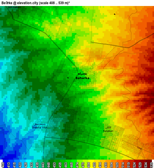
Beḧirke (Arbīl, Arbil), Iraq elevation is 464 meters and Beḧirke elevation in feet is 1522 ft above sea level [src 1]. Beḧirke is a seat of a third-order administrative division (feature code) with elevation that is 171 meters (561 ft) bigger than average city elevation in Iraq.
Below is the Elevation map of Beḧirke, which displays elevation range with different colors. Scale of the first map is from 408 to 539 m (1339 to 1768 ft) with average elevation of 470.7 meters (=1544 ft) [note 1]
These maps also provides idea of topography and contour of this city, they are displayed at different zoom levels. More info about maps, scale and edge coordinates you can find below images.
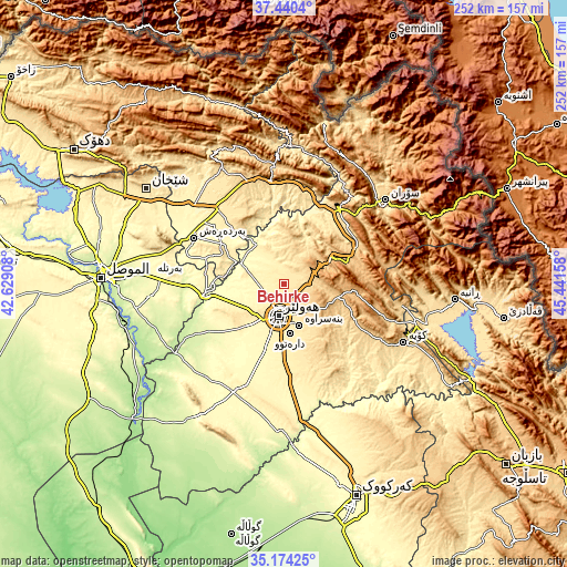
| \ | Map #1 | Topo.Map |
| Scale [m] | 408..539 m | × |
| Scale [ft] | 1339..1768 ft | × |
| Average | 470.7 m = 1544 ft | × |
| Width | 7.87 km = 4.9 mi | 252 km = 156.6 mi |
| Height | 7.87 km = 4.9 mi | 252 km = 156.6 mi |
| ↑Max Latitude | 36.350962° | 37.4404° |
| Latitude at center | 36.31556° | 36.31556° |
| ↓Min Latitude | 36.280142° | 35.17425° |
| ← Min Longitude | 43.991385° | 42.62908° |
| Longitude center | 44.03533° | 44.03533° |
| →Max Longitude | 44.079275° | 45.44158° |
Nearby cities:
Cities around Beḧirke sort by population:
• Erbil elevation 428 m
14.9 km,  188°
188°
• Soran 679 m
59 km,  50°
50°
• ‘Aqrah 716 m
51 km,  345°
345°
• Ruwāndiz 797 m
54.7 km, 52°
• Hīrān 906 m
41.3 km,  95°
95°
• Nāḩiyat Hīrān 1036 m
40.8 km, 95°
• Qushtepe 396 m
34.9 km,  179°
179°
• Xebat 280 m
32.9 km,  262°
262°
• Shaqlāwah 913 m
27.8 km,  69°
69°
• Dare Tû 439 m
21.8 km,  174°
174°
• Kasnazān 587 m
15.5 km,  145°
145°
• ‘Aynkāwah 413 m
10.1 km,  201°
201°
Multilingual:
 En español:
Beḧirke elevación 464 m.
 En France:
Beḧirke élévation 464 m.


Sources and notes:
- [note 1] Map square and city borders are not equal. Map elevation data is calculated only from area inside that square.
- [src 1] Elevation data from geonames database provided with same terms of usage.
- [src 2] The elevation map of Beḧirke is generated using elevation data from NASA's 3 arcsec (90m) resolution SRTM data.
- [src 3] Base (background) map © OpenStreetMap contributors tiles are generated by Geofabrik and OpenTopoMap.
Copyright & License:
This Beḧirke Elevation Map is licensed under CC BY-SA. You may reuse any part from this page, if you give a proper credit by linking to this URL:
 More info on terms of use page.