Soran elevation
Soran (Arbīl, Soran District), Iraq elevation is 679 meters and Soran elevation in feet is 2228 ft above sea level [src 1]. Soran is a seat of a second-order administrative division (feature code) with elevation that is 386 meters (1266 ft) bigger than average city elevation in Iraq.
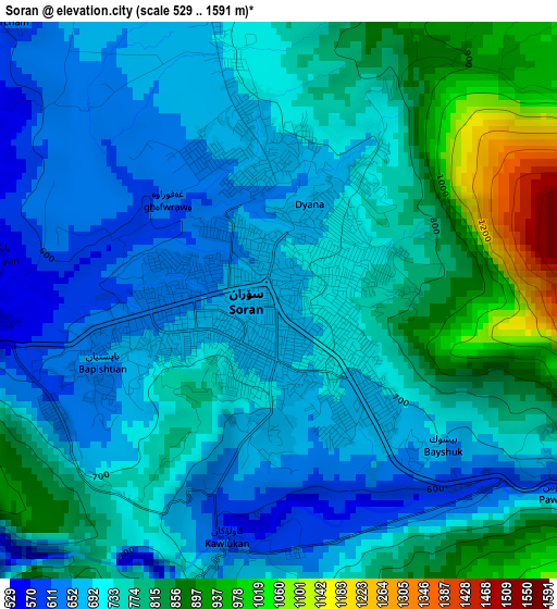
Below is the Elevation map of Soran, which displays elevation range with different colors. Scale of the first map is from 529 to 1591 m (1736 to 5220 ft) with average elevation of 745.8 meters (=2447 ft) [note 1]
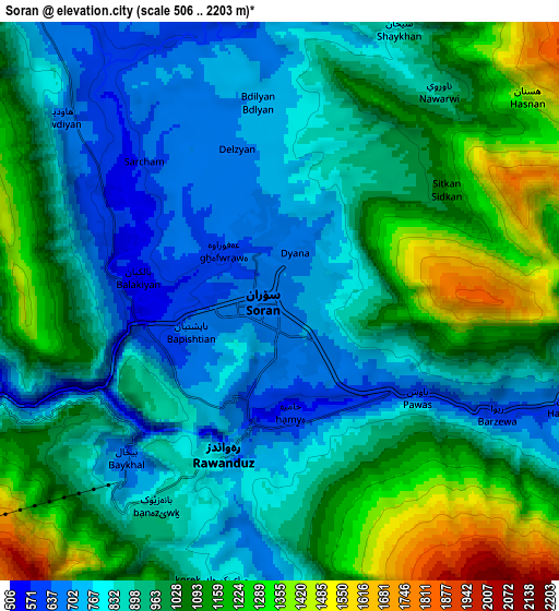
These maps also provides idea of topography and contour of this city, they are displayed at different zoom levels. More info about maps, scale and edge coordinates you can find below images.
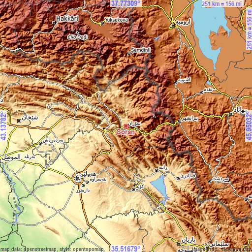
| \ | Map #1 | Map #2 | Topo.Map |
| Scale [m] | 529..1591 m | 506..2203 m | × |
| Scale [ft] | 1736..5220 ft | 1660..7228 ft | × |
| Average | 745.8 m = 2447 ft | 966.3 m = 3170 ft | × |
| Width | 7.84 km = 4.9 mi | 15.68 km = 9.7 mi | 250.9 km = 155.9 mi |
| Height | 7.84 km = 4.9 mi | 15.68 km = 9.7 mi | 250.9 km = 155.9 mi |
| ↑Max Latitude | 36.688448° | 36.723679° | 37.77309° |
| Latitude at center | 36.6532° | 36.6532° | 36.6532° |
| ↓Min Latitude | 36.617936° | 36.582656° | 35.51679° |
| ← Min Longitude | 44.500125° | 44.456179° | 43.13782° |
| Longitude center | 44.54407° | 44.54407° | 44.54407° |
| →Max Longitude | 44.588015° | 44.631961° | 45.95032° |
Nearby cities:
Cities around Soran sort by population:
• Koysinceq elevation 600 m
63.9 km,  173°
173°
• ‘Aqrah 716 m
59.1 km,  281°
281°
• Ruwāndiz 797 m
4.9 km,  201°
201°
• ‘Aynkāwah 413 m
68 km,  226°
226°
• Kasnazān 587 m
62.3 km,  216°
216°
• Beḧirke 464 m
59 km, 230°
• Ṟaniye 574 m
53.6 km,  145°
145°
• Hīrān 906 m
42 km,  186°
186°
• Nāḩiyat Hīrān 1036 m
41.9 km, 186°
• Shaqlāwah 913 m
33.9 km, 215°
• Choman 1111 m
30.8 km,  93°
93°
• Mêrgasur 1190 m
30 km,  314°
314°
Multilingual:
 En español:
Soran elevación 679 m.
 En France:
Soran élévation 679 m.


Sources and notes:
- [note 1] Map square and city borders are not equal. Map elevation data is calculated only from area inside that square.
- [src 1] Elevation data from geonames database provided with same terms of usage.
- [src 2] The elevation map of Soran is generated using elevation data from NASA's 3 arcsec (90m) resolution SRTM data.
- [src 3] Base (background) map © OpenStreetMap contributors tiles are generated by Geofabrik and OpenTopoMap.
Copyright & License:
This Soran Elevation Map is licensed under CC BY-SA. You may reuse any part from this page, if you give a proper credit by linking to this URL:
 More info on terms of use page.