Xebat elevation
Xebat (Arbīl, Arbil), Iraq elevation is 280 meters and Xebat elevation in feet is 919 ft above sea level [src 1]. Xebat is a seat of a second-order administrative division (feature code) with elevation that is 13 meters (43 ft) smaller than average city elevation in Iraq.
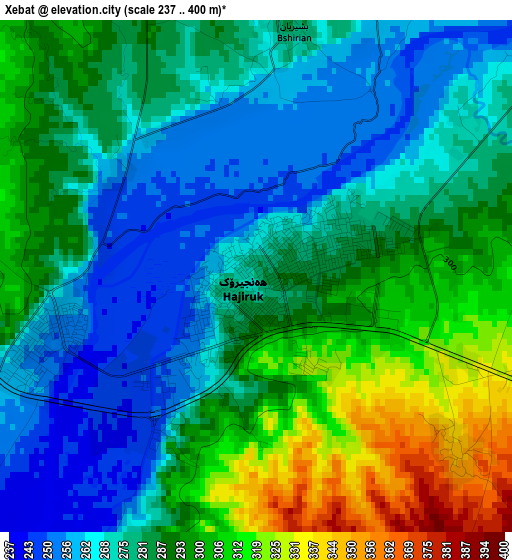
Below is the Elevation map of Xebat, which displays elevation range with different colors. Scale of the first map is from 237 to 400 m (778 to 1312 ft) with average elevation of 284.6 meters (=934 ft) [note 1]
These maps also provides idea of topography and contour of this city, they are displayed at different zoom levels. More info about maps, scale and edge coordinates you can find below images.
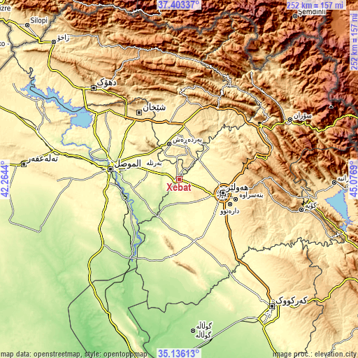
| \ | Map #1 | Topo.Map |
| Scale [m] | 237..400 m | × |
| Scale [ft] | 778..1312 ft | × |
| Average | 284.6 m = 934 ft | × |
| Width | 7.88 km = 4.9 mi | 252.1 km = 156.6 mi |
| Height | 7.88 km = 4.9 mi | 252.1 km = 156.6 mi |
| ↑Max Latitude | 36.313399° | 37.40337° |
| Latitude at center | 36.27798° | 36.27798° |
| ↓Min Latitude | 36.242545° | 35.13613° |
| ← Min Longitude | 43.626705° | 42.2644° |
| Longitude center | 43.67065° | 43.67065° |
| →Max Longitude | 43.714595° | 45.0769° |
Nearby cities:
Cities around Xebat sort by population:
• Al Mawşil al Jadīdah elevation 239 m
51 km,  276°
276°
• Mosul 228 m
49.8 km, 277°
• Erbil 428 m
32.4 km,  108°
108°
• Al-Hamdaniya 274 m
26.3 km,  268°
268°
• Tallkayf 279 m
54.6 km,  295°
295°
• Mexmur 266 m
56.4 km,  188°
188°
• Ash Shaykhān 512 m
54.5 km,  328°
328°
• Qushtepe 396 m
45.1 km,  132°
132°
• Kasnazān 587 m
42.3 km,  101°
101°
• Dare Tû 439 m
39 km,  116°
116°
• Beḧirke 464 m
32.9 km,  82°
82°
• ‘Aynkāwah 413 m
29.5 km, 100°
Multilingual:
 En español:
Xebat elevación 280 m.
 En France:
Xebat élévation 280 m.


Sources and notes:
- [note 1] Map square and city borders are not equal. Map elevation data is calculated only from area inside that square.
- [src 1] Elevation data from geonames database provided with same terms of usage.
- [src 2] The elevation map of Xebat is generated using elevation data from NASA's 3 arcsec (90m) resolution SRTM data.
- [src 3] Base (background) map © OpenStreetMap contributors tiles are generated by Geofabrik and OpenTopoMap.
Copyright & License:
This Xebat Elevation Map is licensed under CC BY-SA. You may reuse any part from this page, if you give a proper credit by linking to this URL:
 More info on terms of use page.