Chīma elevation
Chīma (Punjab, Ludhiana), India elevation is 264 meters and Chīma elevation in feet is 866 ft above sea level [src 1]. Chīma is a populated place (feature code) with elevation that is 29 meters (95 ft) smaller than average city elevation in India.
Below is the Elevation map of Chīma, which displays elevation range with different colors. Scale of the first map is from 246 to 277 m (807 to 909 ft) with average elevation of 260.7 meters (=855 ft) [note 1]
These maps also provides idea of topography and contour of this city, they are displayed at different zoom levels. More info about maps, scale and edge coordinates you can find below images.
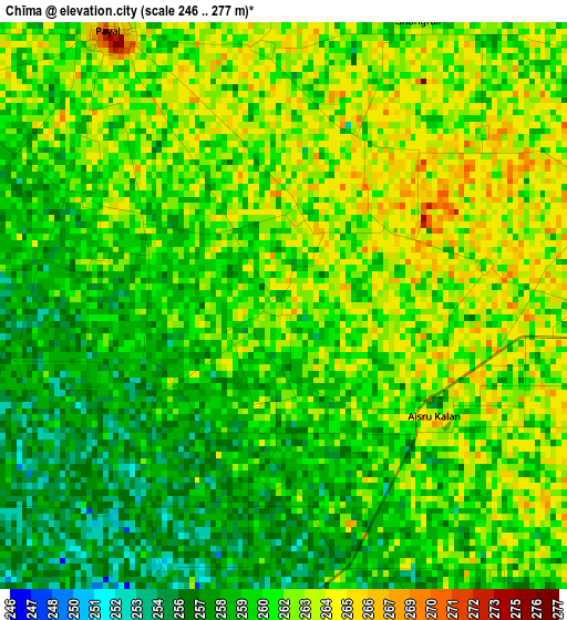
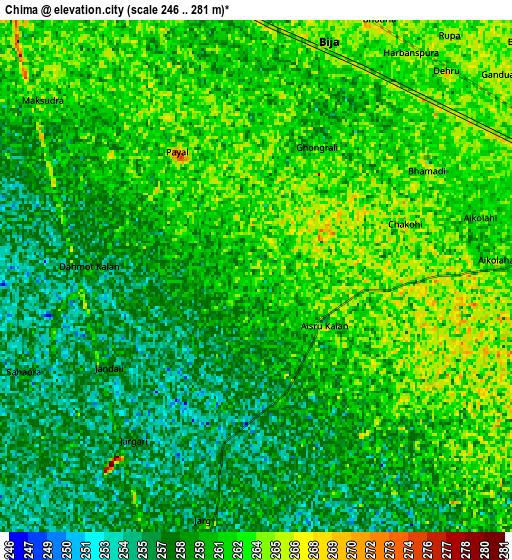
| \ | Map #1 | Map #2 | Topo.Map |
| Scale [m] | 246..277 m | 246..281 m | × |
| Scale [ft] | 807..909 ft | 807..922 ft | × |
| Average | 260.7 m = 855 ft | 260.2 m = 854 ft | × |
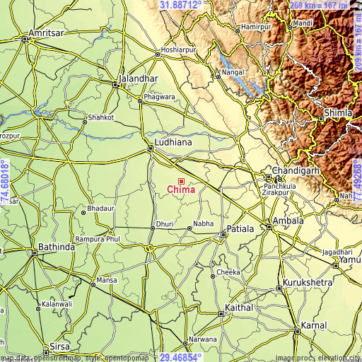
| Width | 8.4 km = 5.2 mi | 16.81 km = 10.4 mi | 268.9 km = 167.1 mi |
| Height | 8.4 km = 5.2 mi | 16.81 km = 10.4 mi | 268.9 km = 167.1 mi |
| ↑Max Latitude | 30.723185° | 30.760955° | 31.88712° |
| Latitude at center | 30.6854° | 30.6854° | 30.6854° |
| ↓Min Latitude | 30.6476° | 30.609786° | 29.46854° |
| ← Min Longitude | 76.042485° | 75.998539° | 74.68018° |
| Longitude center | 76.08643° | 76.08643° | 76.08643° |
| →Max Longitude | 76.130375° | 76.174321° | 77.49268° |
Nearby cities:
Cities around Chīma sort by population:
• Ludhiāna elevation 256 m
33.6 km,  318°
318°
• Khanna 269 m
13.1 km,  80°
80°
• Māler Kotla 251 m
26.2 km,  229°
229°
• Nābha 256 m
35 km,  169°
169°
• Sirhind 270 m
28.9 km,  99°
99°
• Dorāha 262 m
14 km,  334°
334°
• Māchhīwāra 261 m
27.8 km,  22°
22°
• Samrāla 271 m
19.6 km,  31°
31°
• Basi 275 m
30.1 km,  89°
89°
• Amloh 267 m
16.3 km,  121°
121°
• Rāhon 263 m
41 km,  4°
4°
• Khamānon Kalān 275 m
29.5 km,  60°
60°
Multilingual:
 En español:
Chīma elevación 264 m.
 En France:
Chīma élévation 264 m.


Sources and notes:
- [note 1] Map square and city borders are not equal. Map elevation data is calculated only from area inside that square.
- [src 1] Elevation data from geonames database provided with same terms of usage.
- [src 2] The elevation map of Chīma is generated using elevation data from NASA's 3 arcsec (90m) resolution SRTM data.
- [src 3] Base (background) map © OpenStreetMap contributors tiles are generated by Geofabrik and OpenTopoMap.
Copyright & License:
This Chīma Elevation Map is licensed under CC BY-SA. You may reuse any part from this page, if you give a proper credit by linking to this URL:
 More info on terms of use page.