Andol elevation
Andol (Telangana, Medak), India elevation is 503 meters and Andol elevation in feet is 1650 ft above sea level [src 1]. Andol is a populated place (feature code) with elevation that is 210 meters (689 ft) bigger than average city elevation in India.
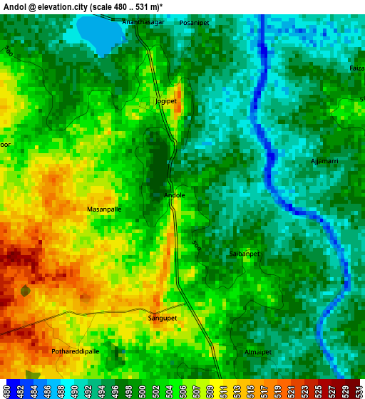
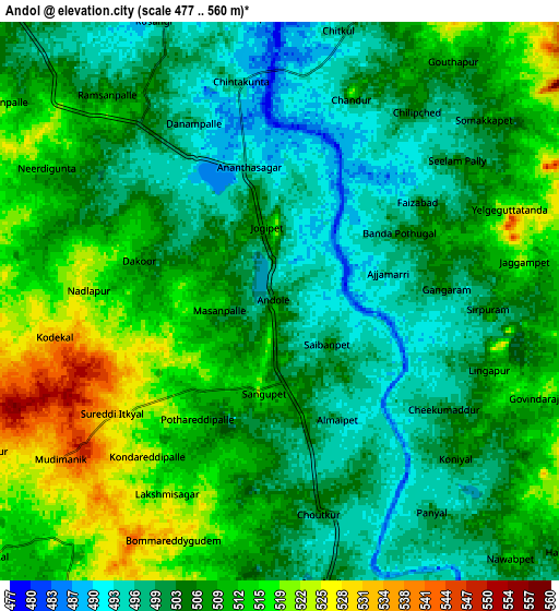
Below is the Elevation map of Andol, which displays elevation range with different colors. Scale of the first map is from 480 to 531 m (1575 to 1742 ft) with average elevation of 500.4 meters (=1642 ft) [note 1]
These maps also provides idea of topography and contour of this city, they are displayed at different zoom levels. More info about maps, scale and edge coordinates you can find below images.
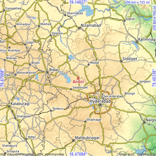
| \ | Map #1 | Map #2 | Topo.Map |
| Scale [m] | 480..531 m | 477..560 m | × |
| Scale [ft] | 1575..1742 ft | 1565..1837 ft | × |
| Average | 500.4 m = 1642 ft | 506.4 m = 1661 ft | × |
| Width | 9.3 km = 5.8 mi | 18.61 km = 11.6 mi | 297.7 km = 185 mi |
| Height | 9.3 km = 5.8 mi | 18.61 km = 11.6 mi | 297.7 km = 185 mi |
| ↑Max Latitude | 17.856413° | 17.898237° | 19.14827° |
| Latitude at center | 17.81458° | 17.81458° | 17.81458° |
| ↓Min Latitude | 17.772737° | 17.730884° | 16.47084° |
| ← Min Longitude | 78.033185° | 77.989239° | 76.67088° |
| Longitude center | 78.07713° | 78.07713° | 78.07713° |
| →Max Longitude | 78.121075° | 78.165021° | 79.48338° |
Nearby cities:
Cities around Andol sort by population:
• Kūkatpalli elevation 566 m
51.1 km,  135°
135°
• Quthbullapur 554 m
53.3 km,  130°
130°
• Serilingampalle 564 m
43 km,  146°
146°
• Sangāreddi 514 m
21.1 km,  177°
177°
• Patancheru 540 m
37 km, 147°
• Zahirābād 626 m
51.9 km,  253°
253°
• Medak 474 m
32.2 km,  37°
37°
• Sadāseopet 550 m
25.4 km,  211°
211°
• Singāpur 594 m
38.7 km,  172°
172°
• Chandūr 503 m
7.1 km,  20°
20°
• Nārsingi 551 m
44.8 km,  55°
55°
• Medchal 591 m
47.5 km,  115°
115°
Multilingual:
 En español:
Andol elevación 503 m.
 En France:
Andol élévation 503 m.


Sources and notes:
- [note 1] Map square and city borders are not equal. Map elevation data is calculated only from area inside that square.
- [src 1] Elevation data from geonames database provided with same terms of usage.
- [src 2] The elevation map of Andol is generated using elevation data from NASA's 3 arcsec (90m) resolution SRTM data.
- [src 3] Base (background) map © OpenStreetMap contributors tiles are generated by Geofabrik and OpenTopoMap.
Copyright & License:
This Andol Elevation Map is licensed under CC BY-SA. You may reuse any part from this page, if you give a proper credit by linking to this URL:
 More info on terms of use page.