Asifābād elevation
Asifābād (Telangana, Kumuram Bheem Asifabad), India elevation is 215 meters and Asifābād elevation in feet is 705 ft above sea level [src 1]. Asifābād is a seat of a second-order administrative division (feature code) with elevation that is 78 meters (256 ft) smaller than average city elevation in India.
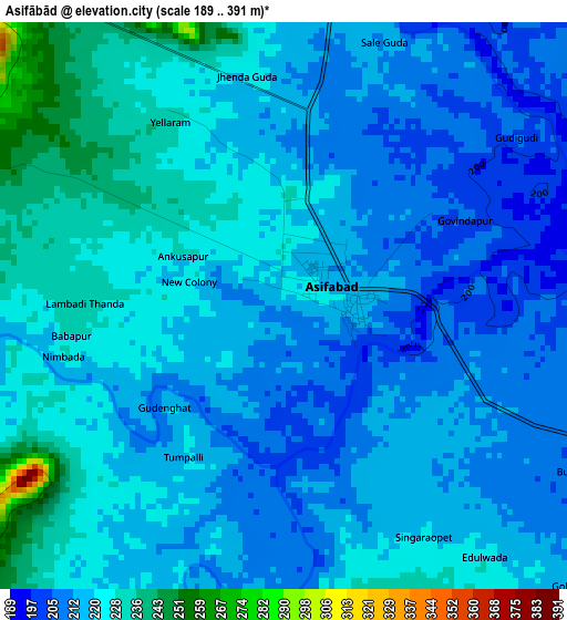
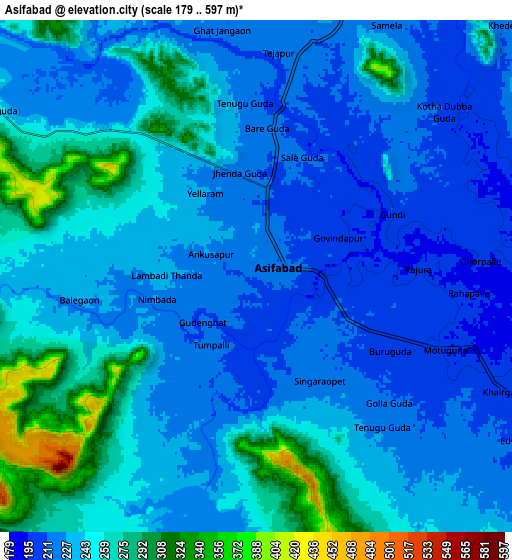
Below is the Elevation map of Asifābād, which displays elevation range with different colors. Scale of the first map is from 189 to 391 m (620 to 1283 ft) with average elevation of 218.5 meters (=717 ft) [note 1]
These maps also provides idea of topography and contour of this city, they are displayed at different zoom levels. More info about maps, scale and edge coordinates you can find below images.
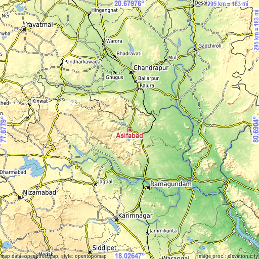
| \ | Map #1 | Map #2 | Topo.Map |
| Scale [m] | 189..391 m | 179..597 m | × |
| Scale [ft] | 620..1283 ft | 587..1959 ft | × |
| Average | 218.5 m = 717 ft | 241.9 m = 794 ft | × |
| Width | 9.22 km = 5.7 mi | 18.44 km = 11.5 mi | 295 km = 183.3 mi |
| Height | 9.22 km = 5.7 mi | 18.44 km = 11.5 mi | 295 km = 183.3 mi |
| ↑Max Latitude | 19.399966° | 19.44141° | 20.67976° |
| Latitude at center | 19.35851° | 19.35851° | 19.35851° |
| ↓Min Latitude | 19.317044° | 19.275567° | 18.02647° |
| ← Min Longitude | 79.240205° | 79.196259° | 77.8779° |
| Longitude center | 79.28415° | 79.28415° | 79.28415° |
| →Max Longitude | 79.328095° | 79.372041° | 80.6904° |
Nearby cities:
Cities around Asifābād sort by population:
• Rāmgundam elevation 148 m
64.5 km,  164°
164°
• Ballālpur 188 m
54.7 km,  6°
6°
• Mancherāl 149 m
56.3 km, 164°
• Bellampalli 206 m
40.2 km,  146°
146°
• Mandamarri 172 m
48.1 km, 155°
• Rājūra 193 m
47.6 km, 10°
• Chāndur 248 m
43.4 km,  344°
344°
• Nāspur 143 m
60 km, 161°
• Lakshettipet 141 m
55.1 km,  187°
187°
• Sirpur 174 m
33.4 km,  66°
66°
• Kothāpet 196 m
20.9 km,  92°
92°
• Kagaznāgār 176 m
19.3 km,  98°
98°
Multilingual:
 En español:
Asifābād elevación 215 m.
 En France:
Asifābād élévation 215 m.
 Auf Deutsch:
Asifābād höhe über dem Meeresspiegel ist 215 m.

Sources and notes:
- [note 1] Map square and city borders are not equal. Map elevation data is calculated only from area inside that square.
- [src 1] Elevation data from geonames database provided with same terms of usage.
- [src 2] The elevation map of Asifābād is generated using elevation data from NASA's 3 arcsec (90m) resolution SRTM data.
- [src 3] Base (background) map © OpenStreetMap contributors tiles are generated by Geofabrik and OpenTopoMap.
Copyright & License:
This Asifābād Elevation Map is licensed under CC BY-SA. You may reuse any part from this page, if you give a proper credit by linking to this URL:
 More info on terms of use page.