Lakshettipet elevation
Lakshettipet (Telangana, Karīmnagar), India elevation is 141 meters and Lakshettipet elevation in feet is 463 ft above sea level [src 1]. Lakshettipet is a populated place (feature code) with elevation that is 152 meters (499 ft) smaller than average city elevation in India.
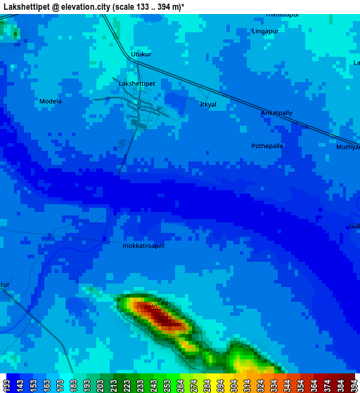
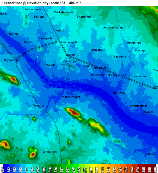
Below is the Elevation map of Lakshettipet, which displays elevation range with different colors. Scale of the first map is from 133 to 394 m (436 to 1293 ft) with average elevation of 163 meters (=535 ft) [note 1]
These maps also provides idea of topography and contour of this city, they are displayed at different zoom levels. More info about maps, scale and edge coordinates you can find below images.
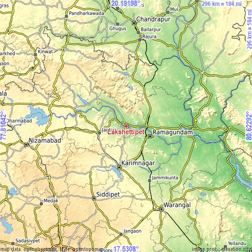
| \ | Map #1 | Map #2 | Topo.Map |
| Scale [m] | 133..394 m | 131..406 m | × |
| Scale [ft] | 436..1293 ft | 430..1332 ft | × |
| Average | 163 m = 535 ft | 173.1 m = 568 ft | × |
| Width | 9.25 km = 5.7 mi | 18.5 km = 11.5 mi | 295.9 km = 183.9 mi |
| Height | 9.25 km = 5.7 mi | 18.49 km = 11.5 mi | 295.9 km = 183.9 mi |
| ↑Max Latitude | 18.908249° | 18.949818° | 20.19198° |
| Latitude at center | 18.86667° | 18.86667° | 18.86667° |
| ↓Min Latitude | 18.825081° | 18.783481° | 17.5308° |
| ← Min Longitude | 79.172725° | 79.128779° | 77.81042° |
| Longitude center | 79.21667° | 79.21667° | 79.21667° |
| →Max Longitude | 79.260615° | 79.304561° | 80.62292° |
Nearby cities:
Cities around Lakshettipet sort by population:
• Rāmgundam elevation 148 m
25.8 km,  106°
106°
• Ramagundam 149 m
29.8 km, 114°
• Karīmnagar 279 m
48.4 km,  191°
191°
• Jagtiāl 282 m
32.6 km,  255°
255°
• Mancherāl 149 m
22.3 km,  88°
88°
• Bellampalli 206 m
35.9 km,  54°
54°
• Mandamarri 172 m
29.3 km,  68°
68°
• Koratla 301 m
53.4 km, 264°
• Peddapalli 234 m
32.7 km,  149°
149°
• Manthani 135 m
53 km,  116°
116°
• Nāspur 143 m
25.9 km,  95°
95°
• Kottapalli 294 m
43.2 km,  197°
197°
Multilingual:
 En español:
Lakshettipet elevación 141 m.
 En France:
Lakshettipet élévation 141 m.
 Auf Deutsch:
Lakshettipet höhe über dem Meeresspiegel ist 141 m.

Sources and notes:
- [note 1] Map square and city borders are not equal. Map elevation data is calculated only from area inside that square.
- [src 1] Elevation data from geonames database provided with same terms of usage.
- [src 2] The elevation map of Lakshettipet is generated using elevation data from NASA's 3 arcsec (90m) resolution SRTM data.
- [src 3] Base (background) map © OpenStreetMap contributors tiles are generated by Geofabrik and OpenTopoMap.
Copyright & License:
This Lakshettipet Elevation Map is licensed under CC BY-SA. You may reuse any part from this page, if you give a proper credit by linking to this URL:
 More info on terms of use page.