Atarra elevation
Atarra (Uttar Pradesh, Bānda), India elevation is 141 meters and Atarra elevation in feet is 463 ft above sea level [src 1]. Atarra is a populated place (feature code) with elevation that is 152 meters (499 ft) smaller than average city elevation in India.
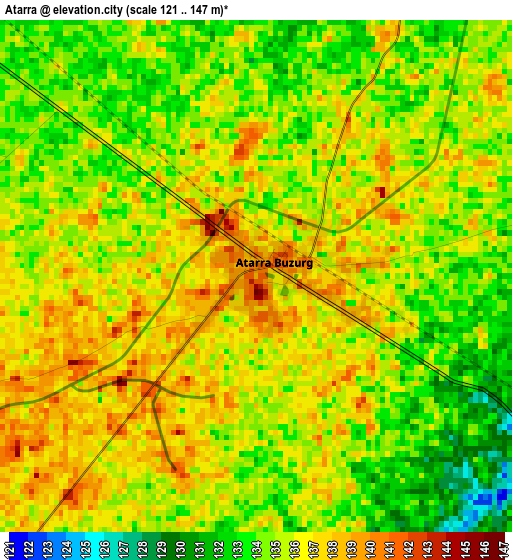
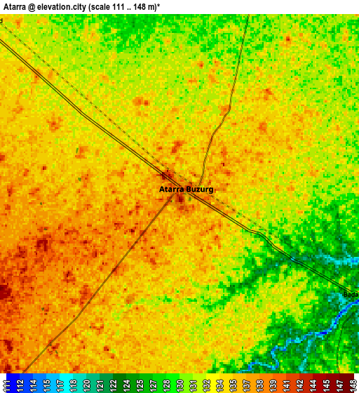
Below is the Elevation map of Atarra, which displays elevation range with different colors. Scale of the first map is from 121 to 147 m (397 to 482 ft) with average elevation of 135.1 meters (=443 ft) [note 1]
These maps also provides idea of topography and contour of this city, they are displayed at different zoom levels. More info about maps, scale and edge coordinates you can find below images.
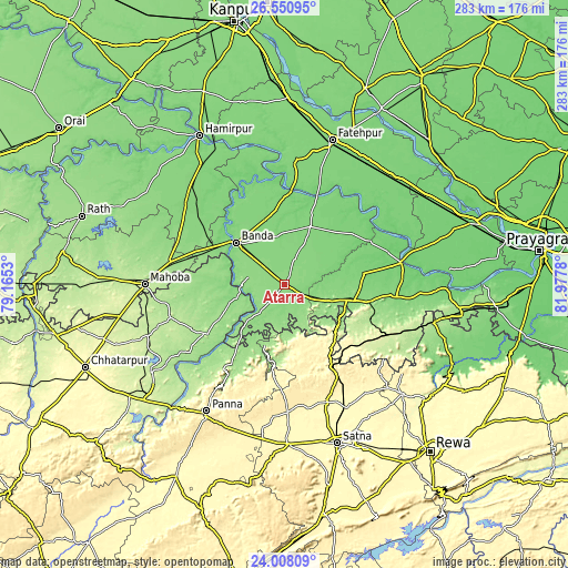
| \ | Map #1 | Map #2 | Topo.Map |
| Scale [m] | 121..147 m | 111..148 m | × |
| Scale [ft] | 397..482 ft | 364..486 ft | × |
| Average | 135.1 m = 443 ft | 133.2 m = 437 ft | × |
| Width | 8.84 km = 5.5 mi | 17.67 km = 11 mi | 282.7 km = 175.7 mi |
| Height | 8.84 km = 5.5 mi | 17.67 km = 11 mi | 282.8 km = 175.7 mi |
| ↑Max Latitude | 25.325908° | 25.365623° | 26.55095° |
| Latitude at center | 25.28618° | 25.28618° | 25.28618° |
| ↓Min Latitude | 25.246439° | 25.206685° | 24.00809° |
| ← Min Longitude | 80.527605° | 80.483659° | 79.1653° |
| Longitude center | 80.57155° | 80.57155° | 80.57155° |
| →Max Longitude | 80.615495° | 80.659441° | 81.9778° |
Nearby cities:
Cities around Atarra sort by population:
• Bānda elevation 127 m
31.9 km,  311°
311°
• Kabrāi 166 m
58.9 km,  282°
282°
• Baberu 129 m
31.9 km,  24°
24°
• Naraini 145 m
14.4 km,  222°
222°
• Ajaigarh 223 m
53.3 km, 216°
• Mānikpur 243 m
58.7 km,  115°
115°
• Rājāpur 111 m
59.3 km,  79°
79°
• Chandla 181 m
45 km,  237°
237°
• Bisenda Buzurg 134 m
13.9 km, 20°
• Tindwāri 121 m
37.1 km,  353°
353°
• Mataundh 145 m
44.9 km,  291°
291°
• Oran 133 m
19.5 km,  61°
61°
Multilingual:
 En español:
Atarra elevación 141 m.
 En France:
Atarra élévation 141 m.


Sources and notes:
- [note 1] Map square and city borders are not equal. Map elevation data is calculated only from area inside that square.
- [src 1] Elevation data from geonames database provided with same terms of usage.
- [src 2] The elevation map of Atarra is generated using elevation data from NASA's 3 arcsec (90m) resolution SRTM data.
- [src 3] Base (background) map © OpenStreetMap contributors tiles are generated by Geofabrik and OpenTopoMap.
Copyright & License:
This Atarra Elevation Map is licensed under CC BY-SA. You may reuse any part from this page, if you give a proper credit by linking to this URL:
 More info on terms of use page.