Kabrāi elevation
Kabrāi (Uttar Pradesh, Mahoba), India elevation is 166 meters and Kabrāi elevation in feet is 545 ft above sea level [src 1]. Kabrāi is a populated place (feature code) with elevation that is 127 meters (417 ft) smaller than average city elevation in India.
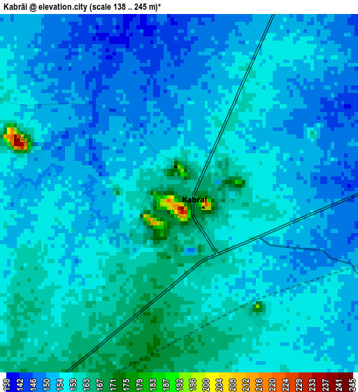
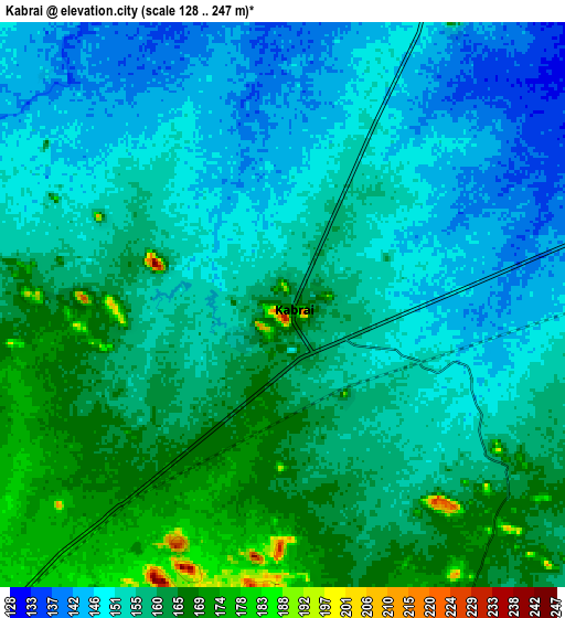
Below is the Elevation map of Kabrāi, which displays elevation range with different colors. Scale of the first map is from 138 to 245 m (453 to 804 ft) with average elevation of 155.8 meters (=511 ft) [note 1]
These maps also provides idea of topography and contour of this city, they are displayed at different zoom levels. More info about maps, scale and edge coordinates you can find below images.
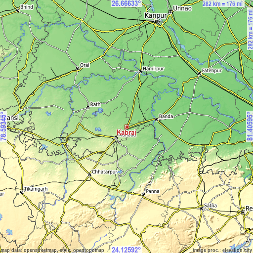
| \ | Map #1 | Map #2 | Topo.Map |
| Scale [m] | 138..245 m | 128..247 m | × |
| Scale [ft] | 453..804 ft | 420..810 ft | × |
| Average | 155.8 m = 511 ft | 155.9 m = 511 ft | × |
| Width | 8.83 km = 5.5 mi | 17.66 km = 11 mi | 282.5 km = 175.5 mi |
| Height | 8.83 km = 5.5 mi | 17.66 km = 11 mi | 282.5 km = 175.5 mi |
| ↑Max Latitude | 25.4425° | 25.482177° | 26.66633° |
| Latitude at center | 25.40281° | 25.40281° | 25.40281° |
| ↓Min Latitude | 25.363107° | 25.323391° | 24.12592° |
| ← Min Longitude | 79.955755° | 79.911809° | 78.59345° |
| Longitude center | 79.9997° | 79.9997° | 79.9997° |
| →Max Longitude | 80.043645° | 80.087591° | 81.40595° |
Nearby cities:
Cities around Kabrāi sort by population:
• Bānda elevation 127 m
34.7 km,  76°
76°
• Mahobā 208 m
17.7 km,  225°
225°
• Rāth 171 m
48.4 km,  296°
296°
• Maudaha 127 m
33.2 km,  20°
20°
• Charkhāri 198 m
25.2 km,  270°
270°
• Kulpahār 198 m
37.4 km,  255°
255°
• Naraini 145 m
53.3 km,  116°
116°
• Kharela 160 m
24.4 km,  309°
309°
• Chandla 181 m
41.7 km,  152°
152°
• Mataundh 145 m
16.2 km, 76°
• Sarīla 148 m
52.7 km,  321°
321°
• Gohānd 153 m
56.2 km, 305°
Multilingual:
 En español:
Kabrāi elevación 166 m.
 En France:
Kabrāi élévation 166 m.


Sources and notes:
- [note 1] Map square and city borders are not equal. Map elevation data is calculated only from area inside that square.
- [src 1] Elevation data from geonames database provided with same terms of usage.
- [src 2] The elevation map of Kabrāi is generated using elevation data from NASA's 3 arcsec (90m) resolution SRTM data.
- [src 3] Base (background) map © OpenStreetMap contributors tiles are generated by Geofabrik and OpenTopoMap.
Copyright & License:
This Kabrāi Elevation Map is licensed under CC BY-SA. You may reuse any part from this page, if you give a proper credit by linking to this URL:
 More info on terms of use page.