Bānsi elevation
Bānsi (Uttar Pradesh, Siddharthnagar), India elevation is 91 meters and Bānsi elevation in feet is 299 ft above sea level [src 1]. Bānsi is a populated place (feature code) with elevation that is 202 meters (663 ft) smaller than average city elevation in India.
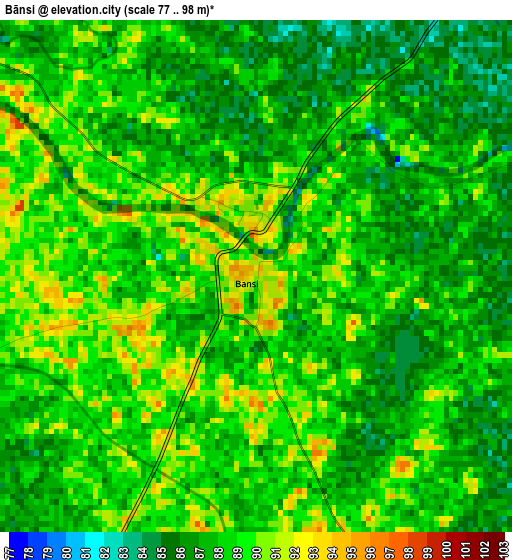
Below is the Elevation map of Bānsi, which displays elevation range with different colors. Scale of the first map is from 77 to 98 m (253 to 322 ft) with average elevation of 87.9 meters (=288 ft) [note 1]
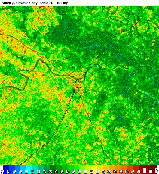
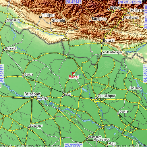
These maps also provides idea of topography and contour of this city, they are displayed at different zoom levels. More info about maps, scale and edge coordinates you can find below images.
| \ | Map #1 | Map #2 | Topo.Map |
| Scale [m] | 77..98 m | 76..101 m | × |
| Scale [ft] | 253..322 ft | 249..331 ft | × |
| Average | 87.9 m = 288 ft | 87.7 m = 288 ft | × |
| Width | 8.69 km = 5.4 mi | 17.39 km = 10.8 mi | 278.2 km = 172.9 mi |
| Height | 8.69 km = 5.4 mi | 17.39 km = 10.8 mi | 278.2 km = 172.9 mi |
| ↑Max Latitude | 27.216577° | 27.25565° | 28.4214° |
| Latitude at center | 27.17749° | 27.17749° | 27.17749° |
| ↓Min Latitude | 27.13839° | 27.099275° | 25.91956° |
| ← Min Longitude | 82.890475° | 82.846529° | 81.52817° |
| Longitude center | 82.93442° | 82.93442° | 82.93442° |
| →Max Longitude | 82.978365° | 83.022311° | 84.34067° |
Nearby cities:
Cities around Bānsi sort by population:
• Gorakhpur elevation 83 m
62.8 km,  136°
136°
• Bastī 92 m
48.4 km,  206°
206°
• Khalīlābād 84 m
47 km,  163°
163°
• Nautanwa 105 m
55.3 km,  59°
59°
• Mahārāganj 96 m
62.2 km,  93°
93°
• Utraula 109 m
53.4 km,  287°
287°
• Mehndāwal 88 m
28.4 km, 142°
• Tulsīpur 115 m
64.7 km,  307°
307°
• Maghar 84 m
50.6 km, 157°
• Pachperwa 108 m
47.1 km,  322°
322°
• Anandnagar 89 m
34.4 km,  104°
104°
• Haraiya 94 m
63.1 km,  227°
227°
Multilingual:
 En español:
Bānsi elevación 91 m.
 En France:
Bānsi élévation 91 m.


Sources and notes:
- [note 1] Map square and city borders are not equal. Map elevation data is calculated only from area inside that square.
- [src 1] Elevation data from geonames database provided with same terms of usage.
- [src 2] The elevation map of Bānsi is generated using elevation data from NASA's 3 arcsec (90m) resolution SRTM data.
- [src 3] Base (background) map © OpenStreetMap contributors tiles are generated by Geofabrik and OpenTopoMap.
Copyright & License:
This Bānsi Elevation Map is licensed under CC BY-SA. You may reuse any part from this page, if you give a proper credit by linking to this URL:
 More info on terms of use page.