Tulsīpur elevation
Tulsīpur (Uttar Pradesh, Balrampur), India elevation is 115 meters and Tulsīpur elevation in feet is 377 ft above sea level [src 1]. Tulsīpur is a populated place (feature code) with elevation that is 178 meters (584 ft) smaller than average city elevation in India.
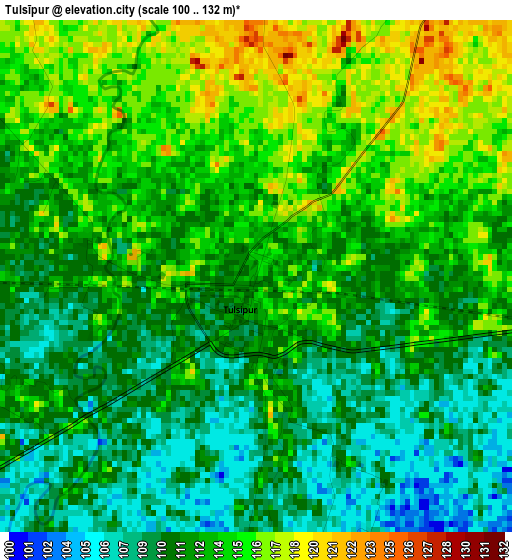
Below is the Elevation map of Tulsīpur, which displays elevation range with different colors. Scale of the first map is from 100 to 132 m (328 to 433 ft) with average elevation of 112.3 meters (=368 ft) [note 1]
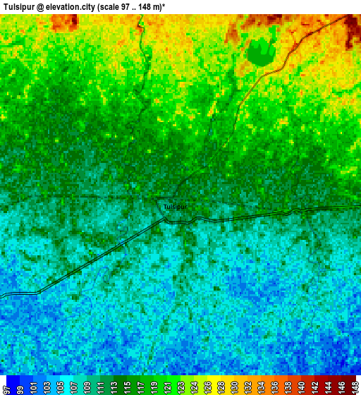
These maps also provides idea of topography and contour of this city, they are displayed at different zoom levels. More info about maps, scale and edge coordinates you can find below images.
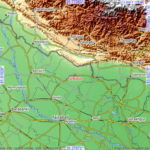
| \ | Map #1 | Map #2 | Topo.Map |
| Scale [m] | 100..132 m | 97..148 m | × |
| Scale [ft] | 328..433 ft | 318..486 ft | × |
| Average | 112.3 m = 368 ft | 113.6 m = 373 ft | × |
| Width | 8.67 km = 5.4 mi | 17.33 km = 10.8 mi | 277.3 km = 172.3 mi |
| Height | 8.67 km = 5.4 mi | 17.33 km = 10.8 mi | 277.3 km = 172.3 mi |
| ↑Max Latitude | 27.572661° | 27.611608° | 28.77353° |
| Latitude at center | 27.5337° | 27.5337° | 27.5337° |
| ↓Min Latitude | 27.494725° | 27.455736° | 26.27972° |
| ← Min Longitude | 82.372585° | 82.328639° | 81.01028° |
| Longitude center | 82.41653° | 82.41653° | 82.41653° |
| →Max Longitude | 82.460475° | 82.504421° | 83.82278° |
Nearby cities:
Cities around Tulsīpur sort by population:
• Bahraigh elevation 127 m
81.1 km,  273°
273°
• Gondā City 113 m
64 km,  225°
225°
• Balrāmpur 112 m
25.6 km,  243°
243°
• Bānsi 91 m
64.7 km,  127°
127°
• Utraula 109 m
23.8 km,  179°
179°
• Bhinga 122 m
51.1 km,  291°
291°
• Nawābganj 100 m
79.3 km,  200°
200°
• Pachperwa 108 m
22.5 km,  96°
96°
• Ikauna 118 m
44.1 km, 269°
• Mankāpur 102 m
56.7 km, 199°
• Khargupur 117 m
45.8 km,  247°
247°
• Katra 115 m
38.6 km, 265°
Multilingual:
 En español:
Tulsīpur elevación 115 m.
 En France:
Tulsīpur élévation 115 m.
 Auf Deutsch:
Tulsīpur höhe über dem Meeresspiegel ist 115 m.

Sources and notes:
- [note 1] Map square and city borders are not equal. Map elevation data is calculated only from area inside that square.
- [src 1] Elevation data from geonames database provided with same terms of usage.
- [src 2] The elevation map of Tulsīpur is generated using elevation data from NASA's 3 arcsec (90m) resolution SRTM data.
- [src 3] Base (background) map © OpenStreetMap contributors tiles are generated by Geofabrik and OpenTopoMap.
Copyright & License:
This Tulsīpur Elevation Map is licensed under CC BY-SA. You may reuse any part from this page, if you give a proper credit by linking to this URL:
 More info on terms of use page.