Barwādih elevation
Barwādih (Jharkhand, Latehar), India elevation is 290 meters and Barwādih elevation in feet is 951 ft above sea level [src 1]. Barwādih is a populated place (feature code) with elevation that is 3 meters (10 ft) smaller than average city elevation in India.
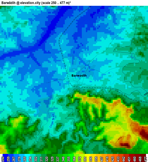
Below is the Elevation map of Barwādih, which displays elevation range with different colors. Scale of the first map is from 250 to 477 m (820 to 1565 ft) with average elevation of 303 meters (=994 ft) [note 1]
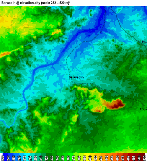
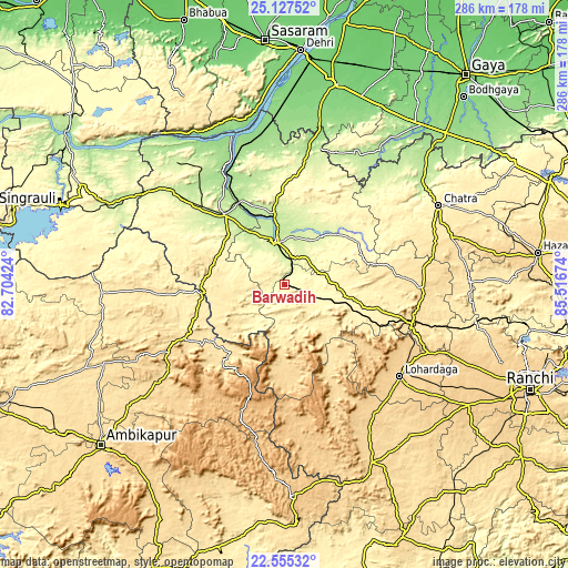
These maps also provides idea of topography and contour of this city, they are displayed at different zoom levels. More info about maps, scale and edge coordinates you can find below images.
| \ | Map #1 | Map #2 | Topo.Map |
| Scale [m] | 250..477 m | 232..520 m | × |
| Scale [ft] | 820..1565 ft | 761..1706 ft | × |
| Average | 303 m = 994 ft | 320.4 m = 1051 ft | × |
| Width | 8.94 km = 5.6 mi | 17.88 km = 11.1 mi | 286 km = 177.7 mi |
| Height | 8.94 km = 5.6 mi | 17.88 km = 11.1 mi | 286 km = 177.7 mi |
| ↑Max Latitude | 23.887987° | 23.928162° | 25.12752° |
| Latitude at center | 23.8478° | 23.8478° | 23.8478° |
| ↓Min Latitude | 23.8076° | 23.767388° | 22.55532° |
| ← Min Longitude | 84.066545° | 84.022599° | 82.70424° |
| Longitude center | 84.11049° | 84.11049° | 84.11049° |
| →Max Longitude | 84.154435° | 84.198381° | 85.51674° |
Nearby cities:
Cities around Barwādih sort by population:
• Daltonganj elevation 227 m
21.8 km,  347°
347°
• Lohārdagā 666 m
74.1 km,  128°
128°
• Chatrā 440 m
86.9 km,  62°
62°
• Garhwa 203 m
46.4 km,  318°
318°
• Husainābād 153 m
76.5 km, 351°
• Nabīnagar 144 m
84.4 km,  1°
1°
• Lātehār 388 m
41.3 km,  106°
106°
• Dūdhi 250 m
97.2 km,  294°
294°
• Rāmānuj Ganj 436 m
42 km,  263°
263°
• Rāy 431 m
97.8 km,  100°
100°
• Neturhāt 1086 m
44.5 km,  158°
158°
• Balrampur 532 m
57.2 km,  242°
242°
Multilingual:
 En español:
Barwādih elevación 290 m.
 En France:
Barwādih élévation 290 m.
 Auf Deutsch:
Barwādih höhe über dem Meeresspiegel ist 290 m.

Sources and notes:
- [note 1] Map square and city borders are not equal. Map elevation data is calculated only from area inside that square.
- [src 1] Elevation data from geonames database provided with same terms of usage.
- [src 2] The elevation map of Barwādih is generated using elevation data from NASA's 3 arcsec (90m) resolution SRTM data.
- [src 3] Base (background) map © OpenStreetMap contributors tiles are generated by Geofabrik and OpenTopoMap.
Copyright & License:
This Barwādih Elevation Map is licensed under CC BY-SA. You may reuse any part from this page, if you give a proper credit by linking to this URL:
 More info on terms of use page.