Botād elevation
Botād (Gujarat, Botad), India elevation is 89 meters and Botād elevation in feet is 292 ft above sea level [src 1]. Botād is a seat of a second-order administrative division (feature code) with elevation that is 204 meters (669 ft) smaller than average city elevation in India.
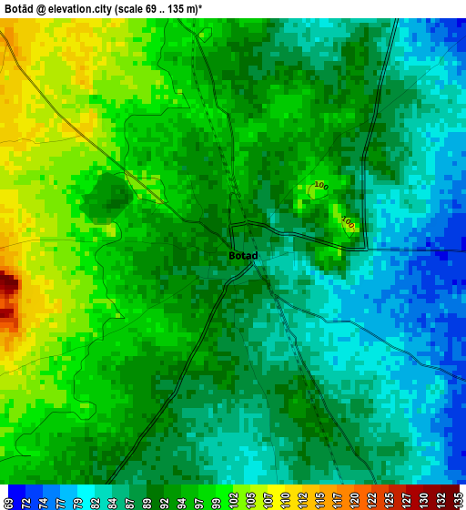
Below is the Elevation map of Botād, which displays elevation range with different colors. Scale of the first map is from 69 to 135 m (226 to 443 ft) with average elevation of 92 meters (=302 ft) [note 1]
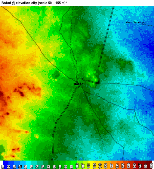
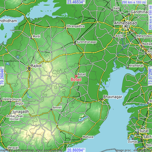
These maps also provides idea of topography and contour of this city, they are displayed at different zoom levels. More info about maps, scale and edge coordinates you can find below images.
| \ | Map #1 | Map #2 | Topo.Map |
| Scale [m] | 69..135 m | 50..155 m | × |
| Scale [ft] | 226..443 ft | 164..509 ft | × |
| Average | 92 m = 302 ft | 89.6 m = 294 ft | × |
| Width | 9.05 km = 5.6 mi | 18.1 km = 11.2 mi | 289.6 km = 179.9 mi |
| Height | 9.05 km = 5.6 mi | 18.1 km = 11.2 mi | 289.6 km = 179.9 mi |
| ↑Max Latitude | 22.209861° | 22.25054° | 23.46534° |
| Latitude at center | 22.16917° | 22.16917° | 22.16917° |
| ↓Min Latitude | 22.128468° | 22.087753° | 20.86094° |
| ← Min Longitude | 71.622765° | 71.578819° | 70.26046° |
| Longitude center | 71.66671° | 71.66671° | 71.66671° |
| →Max Longitude | 71.710655° | 71.754601° | 73.07296° |
Nearby cities:
Cities around Botād sort by population:
• Jasdan elevation 204 m
49.5 km,  252°
252°
• Limbdi 51 m
46.4 km,  18°
18°
• Dhandhuka 31 m
40.5 km,  54°
54°
• Gadhada 89 m
24 km,  202°
202°
• Bābra 161 m
51.8 km,  226°
226°
• Valabhīpur 22 m
38.1 km,  144°
144°
• Dāmnagar 94 m
55.2 km, 196°
• Sāyla 135 m
46.3 km,  335°
335°
• Vinchia 175 m
29.9 km,  278°
278°
• Umrāla 27 m
38.8 km,  158°
158°
• Pāliyād 115 m
14.7 km,  311°
311°
• Dhola 35 m
33.8 km, 161°
Multilingual:
 En español:
Botād elevación 89 m.
 En France:
Botād élévation 89 m.


Sources and notes:
- [note 1] Map square and city borders are not equal. Map elevation data is calculated only from area inside that square.
- [src 1] Elevation data from geonames database provided with same terms of usage.
- [src 2] The elevation map of Botād is generated using elevation data from NASA's 3 arcsec (90m) resolution SRTM data.
- [src 3] Base (background) map © OpenStreetMap contributors tiles are generated by Geofabrik and OpenTopoMap.
Copyright & License:
This Botād Elevation Map is licensed under CC BY-SA. You may reuse any part from this page, if you give a proper credit by linking to this URL:
 More info on terms of use page.