Dalhousie elevation
Dalhousie (Himachal Pradesh, Chamba), India elevation is 1697 meters and Dalhousie elevation in feet is 5568 ft above sea level [src 1]. Dalhousie is a populated place (feature code) with elevation that is 1404 meters (4606 ft) bigger than average city elevation in India.
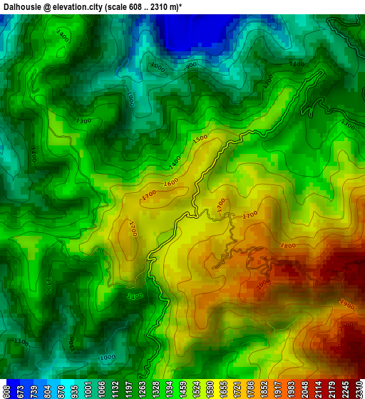
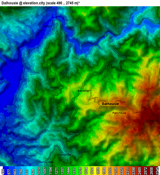
Below is the Elevation map of Dalhousie, which displays elevation range with different colors. Scale of the first map is from 608 to 2310 m (1995 to 7579 ft) with average elevation of 1386.8 meters (=4550 ft) [note 1]
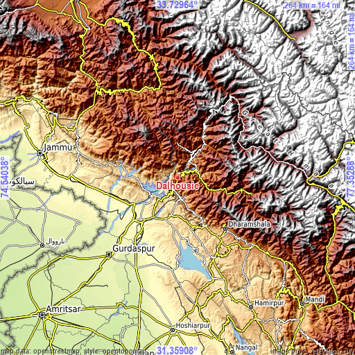
These maps also provides idea of topography and contour of this city, they are displayed at different zoom levels. More info about maps, scale and edge coordinates you can find below images.
| \ | Map #1 | Map #2 | Topo.Map |
| Scale [m] | 608..2310 m | 490..2745 m | × |
| Scale [ft] | 1995..7579 ft | 1608..9006 ft | × |
| Average | 1386.8 m = 4550 ft | 1258.5 m = 4129 ft | × |
| Width | 8.24 km = 5.1 mi | 16.47 km = 10.2 mi | 263.6 km = 163.8 mi |
| Height | 8.24 km = 5.1 mi | 16.47 km = 10.2 mi | 263.6 km = 163.8 mi |
| ↑Max Latitude | 32.589224° | 32.626243° | 33.72964° |
| Latitude at center | 32.55219° | 32.55219° | 32.55219° |
| ↓Min Latitude | 32.515141° | 32.478076° | 31.35908° |
| ← Min Longitude | 75.902685° | 75.858739° | 74.54038° |
| Longitude center | 75.94663° | 75.94663° | 75.94663° |
| →Max Longitude | 75.990575° | 76.034521° | 77.35288° |
Nearby cities:
Cities around Dalhousie sort by population:
• Pathānkot elevation 337 m
41.4 km,  221°
221°
• Kathua 323 m
44.4 km,  242°
242°
• Chamba 951 m
16.9 km,  88°
88°
• Dharamsala 1359 m
50.9 km,  136°
136°
• Bhadarwāh 1636 m
52.1 km,  335°
335°
• Yol 672 m
49.1 km,  151°
151°
• Parol 287 m
53.3 km, 244°
• Nagrota 457 m
56.7 km,  166°
166°
• Kotla 608 m
34.6 km, 166°
• Chuāri Khās 1040 m
14.9 km, 154°
• Chowari 1025 m
14.7 km,  155°
155°
• Bakloh 1336 m
8.5 km,  197°
197°
Multilingual:
 En español:
Dalhousie elevación 1697 m.
 En France:
Dalhousie élévation 1697 m.
 Auf Deutsch:
Dalhousie höhe über dem Meeresspiegel ist 1697 m.

Sources and notes:
- [note 1] Map square and city borders are not equal. Map elevation data is calculated only from area inside that square.
- [src 1] Elevation data from geonames database provided with same terms of usage.
- [src 2] The elevation map of Dalhousie is generated using elevation data from NASA's 3 arcsec (90m) resolution SRTM data.
- [src 3] Base (background) map © OpenStreetMap contributors tiles are generated by Geofabrik and OpenTopoMap.
Copyright & License:
This Dalhousie Elevation Map is licensed under CC BY-SA. You may reuse any part from this page, if you give a proper credit by linking to this URL:
 More info on terms of use page.