Pathānkot elevation
Pathānkot (Punjab, Pathankot), India elevation is 337 meters and Pathānkot elevation in feet is 1106 ft above sea level [src 1]. Pathānkot is a populated place (feature code) with elevation that is 44 meters (144 ft) bigger than average city elevation in India.
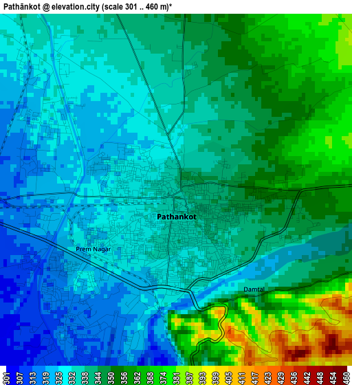
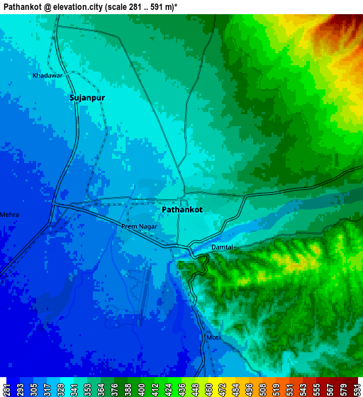
Below is the Elevation map of Pathānkot, which displays elevation range with different colors. Scale of the first map is from 301 to 460 m (988 to 1509 ft) with average elevation of 341.4 meters (=1120 ft) [note 1]
These maps also provides idea of topography and contour of this city, they are displayed at different zoom levels. More info about maps, scale and edge coordinates you can find below images.
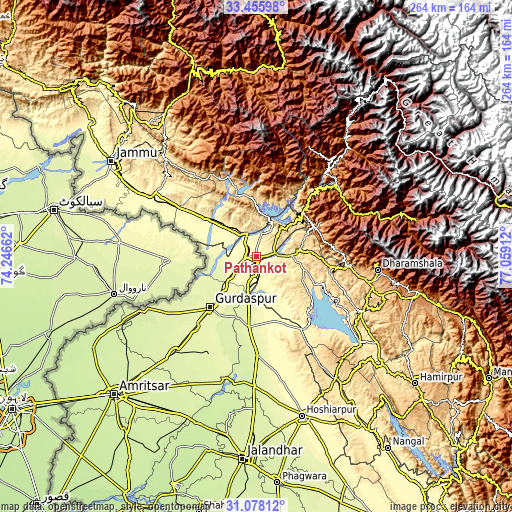
| \ | Map #1 | Map #2 | Topo.Map |
| Scale [m] | 301..460 m | 281..591 m | × |
| Scale [ft] | 988..1509 ft | 922..1939 ft | × |
| Average | 341.4 m = 1120 ft | 351.3 m = 1153 ft | × |
| Width | 8.26 km = 5.1 mi | 16.53 km = 10.3 mi | 264.4 km = 164.3 mi |
| Height | 8.26 km = 5.1 mi | 16.53 km = 10.3 mi | 264.4 km = 164.3 mi |
| ↑Max Latitude | 32.311988° | 32.349121° | 33.45598° |
| Latitude at center | 32.27484° | 32.27484° | 32.27484° |
| ↓Min Latitude | 32.237677° | 32.200498° | 31.07812° |
| ← Min Longitude | 75.608925° | 75.564979° | 74.24662° |
| Longitude center | 75.65287° | 75.65287° | 75.65287° |
| →Max Longitude | 75.696815° | 75.740761° | 77.05912° |
Nearby cities:
Cities around Pathānkot sort by population:
• Kathua elevation 323 m
15.9 km,  311°
311°
• Talwāra 356 m
43.5 km,  149°
149°
• Dīnānagar 273 m
22.9 km,  227°
227°
• Mukeriān 264 m
35.8 km,  185°
185°
• Hirānagar 321 m
41 km,  299°
299°
• Parol 287 m
22 km,  291°
291°
• Dalhousie 1697 m
41.4 km,  41°
41°
• Hājipur 307 m
34.5 km,  163°
163°
• Kotla 608 m
35.9 km,  94°
94°
• Chuāri Khās 1040 m
38.1 km,  62°
62°
• Chowari 1025 m
38 km, 62°
• Bakloh 1336 m
33.8 km,  47°
47°
Multilingual:
 En español:
Pathānkot elevación 337 m.
 En France:
Pathānkot élévation 337 m.
 Auf Deutsch:
Pathānkot höhe über dem Meeresspiegel ist 337 m.

Sources and notes:
- [note 1] Map square and city borders are not equal. Map elevation data is calculated only from area inside that square.
- [src 1] Elevation data from geonames database provided with same terms of usage.
- [src 2] The elevation map of Pathānkot is generated using elevation data from NASA's 3 arcsec (90m) resolution SRTM data.
- [src 3] Base (background) map © OpenStreetMap contributors tiles are generated by Geofabrik and OpenTopoMap.
Copyright & License:
This Pathānkot Elevation Map is licensed under CC BY-SA. You may reuse any part from this page, if you give a proper credit by linking to this URL:
 More info on terms of use page.