Dungarpur elevation
Dungarpur (Gujarat, Bhāvnagar), India elevation is 139 meters and Dungarpur elevation in feet is 456 ft above sea level [src 1]. Dungarpur is a populated place (feature code) with elevation that is 154 meters (505 ft) smaller than average city elevation in India.
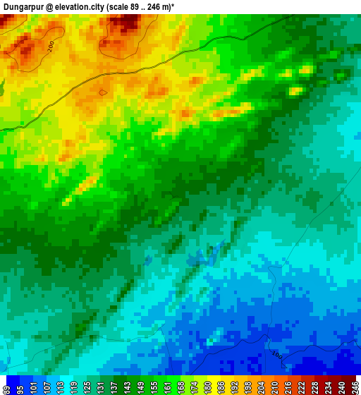
Below is the Elevation map of Dungarpur, which displays elevation range with different colors. Scale of the first map is from 89 to 246 m (292 to 807 ft) with average elevation of 142.8 meters (=469 ft) [note 1]
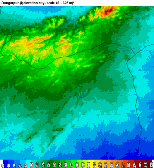
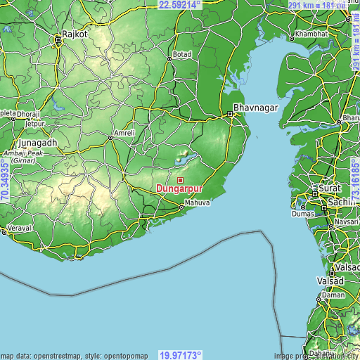
These maps also provides idea of topography and contour of this city, they are displayed at different zoom levels. More info about maps, scale and edge coordinates you can find below images.
| \ | Map #1 | Map #2 | Topo.Map |
| Scale [m] | 89..246 m | 49..326 m | × |
| Scale [ft] | 292..807 ft | 161..1070 ft | × |
| Average | 142.8 m = 469 ft | 124.4 m = 408 ft | × |
| Width | 9.11 km = 5.7 mi | 18.21 km = 11.3 mi | 291.4 km = 181.1 mi |
| Height | 9.11 km = 5.7 mi | 18.21 km = 11.3 mi | 291.4 km = 181.1 mi |
| ↑Max Latitude | 21.328711° | 21.369641° | 22.59214° |
| Latitude at center | 21.28777° | 21.28777° | 21.28777° |
| ↓Min Latitude | 21.246817° | 21.205853° | 19.97173° |
| ← Min Longitude | 71.711655° | 71.667709° | 70.34935° |
| Longitude center | 71.7556° | 71.7556° | 71.7556° |
| →Max Longitude | 71.799545° | 71.843491° | 73.16185° |
Nearby cities:
Cities around Dungarpur sort by population:
• Kundla elevation 134 m
46.9 km,  277°
277°
• Savarkundla 145 m
47.2 km, 276°
• Pālitāna 67 m
27.3 km,  14°
14°
• Sihor 69 m
51.7 km,  24°
24°
• Gariadhar 98 m
33.5 km,  326°
326°
• Rājula 47 m
42.6 km,  229°
229°
• Talāja 25 m
29.9 km,  76°
76°
• Lāthi 130 m
61.5 km,  321°
321°
• Dāmnagar 94 m
51.3 km, 331°
• Umrāla 27 m
62 km,  4°
4°
• Vartej 31 m
59.6 km,  32°
32°
• Katpur 9 m
25.8 km,  170°
170°
Multilingual:
 En español:
Dungarpur elevación 139 m.
 En France:
Dungarpur élévation 139 m.
 Auf Deutsch:
Dungarpur höhe über dem Meeresspiegel ist 139 m.

Sources and notes:
- [note 1] Map square and city borders are not equal. Map elevation data is calculated only from area inside that square.
- [src 1] Elevation data from geonames database provided with same terms of usage.
- [src 2] The elevation map of Dungarpur is generated using elevation data from NASA's 3 arcsec (90m) resolution SRTM data.
- [src 3] Base (background) map © OpenStreetMap contributors tiles are generated by Geofabrik and OpenTopoMap.
Copyright & License:
This Dungarpur Elevation Map is licensed under CC BY-SA. You may reuse any part from this page, if you give a proper credit by linking to this URL:
 More info on terms of use page.