Farīdpur elevation
Farīdpur (Uttar Pradesh, Bareilly), India elevation is 170 meters and Farīdpur elevation in feet is 558 ft above sea level [src 1]. Farīdpur is a populated place (feature code) with elevation that is 123 meters (404 ft) smaller than average city elevation in India.
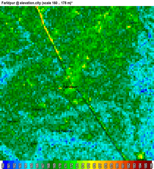
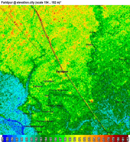
Below is the Elevation map of Farīdpur, which displays elevation range with different colors. Scale of the first map is from 160 to 178 m (525 to 584 ft) with average elevation of 167.3 meters (=549 ft) [note 1]
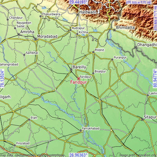
These maps also provides idea of topography and contour of this city, they are displayed at different zoom levels. More info about maps, scale and edge coordinates you can find below images.
| \ | Map #1 | Map #2 | Topo.Map |
| Scale [m] | 160..178 m | 154..182 m | × |
| Scale [ft] | 525..584 ft | 505..597 ft | × |
| Average | 167.3 m = 549 ft | 166.2 m = 545 ft | × |
| Width | 8.61 km = 5.3 mi | 17.22 km = 10.7 mi | 275.6 km = 171.2 mi |
| Height | 8.61 km = 5.3 mi | 17.22 km = 10.7 mi | 275.6 km = 171.2 mi |
| ↑Max Latitude | 28.248689° | 28.287393° | 29.44193° |
| Latitude at center | 28.20997° | 28.20997° | 28.20997° |
| ↓Min Latitude | 28.171237° | 28.132491° | 26.96363° |
| ← Min Longitude | 79.497545° | 79.453599° | 78.13524° |
| Longitude center | 79.54149° | 79.54149° | 79.54149° |
| →Max Longitude | 79.585435° | 79.629381° | 80.94774° |
Nearby cities:
Cities around Farīdpur sort by population:
• Bareilly elevation 178 m
20.5 km,  328°
328°
• Bīsalpur 172 m
27.4 km,  70°
70°
• Tilhar 161 m
33.6 km,  144°
144°
• Aonla 175 m
37.5 km,  280°
280°
• Nawābganj 184 m
37.9 km,  13°
13°
• Mīrānpur Katra 162 m
23.6 km,  148°
148°
• Dātāganj 159 m
24.3 km,  212°
212°
• Fatehganj West 172 m
36.6 km,  321°
321°
• Shāhi 180 m
43.7 km, 329°
• Bilsanda 171 m
40.3 km,  84°
84°
• Khudāganj 166 m
18.4 km,  112°
112°
• Barkhera Kalān 181 m
37.4 km,  43°
43°
Multilingual:
 En español:
Farīdpur elevación 170 m.
 En France:
Farīdpur élévation 170 m.
 Auf Deutsch:
Farīdpur höhe über dem Meeresspiegel ist 170 m.

Sources and notes:
- [note 1] Map square and city borders are not equal. Map elevation data is calculated only from area inside that square.
- [src 1] Elevation data from geonames database provided with same terms of usage.
- [src 2] The elevation map of Farīdpur is generated using elevation data from NASA's 3 arcsec (90m) resolution SRTM data.
- [src 3] Base (background) map © OpenStreetMap contributors tiles are generated by Geofabrik and OpenTopoMap.
Copyright & License:
This Farīdpur Elevation Map is licensed under CC BY-SA. You may reuse any part from this page, if you give a proper credit by linking to this URL:
 More info on terms of use page.