Aonla elevation
Aonla (Uttar Pradesh, Bareilly), India elevation is 175 meters and Aonla elevation in feet is 574 ft above sea level [src 1]. Aonla is a populated place (feature code) with elevation that is 118 meters (387 ft) smaller than average city elevation in India.
Below is the Elevation map of Aonla, which displays elevation range with different colors. Scale of the first map is from 161 to 185 m (528 to 607 ft) with average elevation of 171 meters (=561 ft) [note 1]
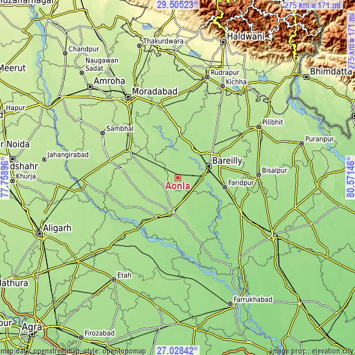
These maps also provides idea of topography and contour of this city, they are displayed at different zoom levels. More info about maps, scale and edge coordinates you can find below images.
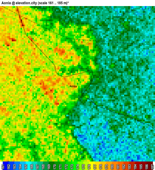
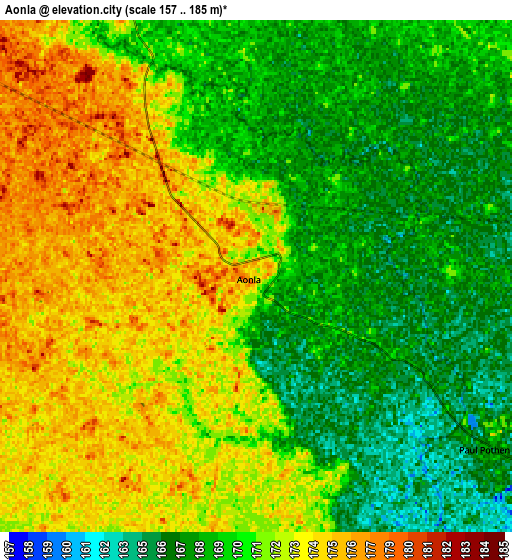
| \ | Map #1 | Map #2 | Topo.Map |
| Scale [m] | 161..185 m | 157..185 m | × |
| Scale [ft] | 528..607 ft | 515..607 ft | × |
| Average | 171 m = 561 ft | 170.8 m = 560 ft | × |
| Width | 8.61 km = 5.3 mi | 17.21 km = 10.7 mi | 275.4 km = 171.1 mi |
| Height | 8.61 km = 5.3 mi | 17.21 km = 10.7 mi | 275.4 km = 171.1 mi |
| ↑Max Latitude | 28.312715° | 28.351396° | 29.50523° |
| Latitude at center | 28.27402° | 28.27402° | 28.27402° |
| ↓Min Latitude | 28.235311° | 28.196587° | 27.02842° |
| ← Min Longitude | 79.121265° | 79.077319° | 77.75896° |
| Longitude center | 79.16521° | 79.16521° | 79.16521° |
| →Max Longitude | 79.209155° | 79.253101° | 80.57146° |
Nearby cities:
Cities around Aonla sort by population:
• Bareilly elevation 178 m
28 km,  68°
68°
• Budaun 177 m
26.5 km,  188°
188°
• Ujhāni 173 m
33.8 km,  207°
207°
• Shāhābād 189 m
35.9 km,  334°
334°
• Bisauli 185 m
22.7 km,  279°
279°
• Bilsi 178 m
29.7 km,  237°
237°
• Dātāganj 159 m
36.5 km,  139°
139°
• Fatehganj West 172 m
25.5 km,  32°
32°
• Sarauli 184 m
25.5 km,  343°
343°
• Wazīrganj 178 m
12.7 km, 236°
• Shāhi 180 m
34.1 km, 25°
• Mīrganj 178 m
29.9 km,  8°
8°
Multilingual:
 En español:
Aonla elevación 175 m.
 En France:
Aonla élévation 175 m.


Sources and notes:
- [note 1] Map square and city borders are not equal. Map elevation data is calculated only from area inside that square.
- [src 1] Elevation data from geonames database provided with same terms of usage.
- [src 2] The elevation map of Aonla is generated using elevation data from NASA's 3 arcsec (90m) resolution SRTM data.
- [src 3] Base (background) map © OpenStreetMap contributors tiles are generated by Geofabrik and OpenTopoMap.
Copyright & License:
This Aonla Elevation Map is licensed under CC BY-SA. You may reuse any part from this page, if you give a proper credit by linking to this URL:
 More info on terms of use page.