Gautampura elevation
Gautampura (Madhya Pradesh, Indore), India elevation is 502 meters and Gautampura elevation in feet is 1647 ft above sea level [src 1]. Gautampura is a populated place (feature code) with elevation that is 209 meters (686 ft) bigger than average city elevation in India.
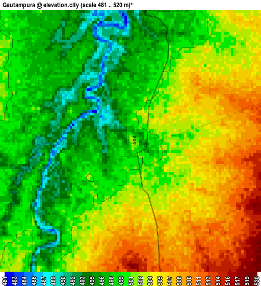
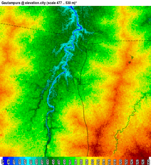
Below is the Elevation map of Gautampura, which displays elevation range with different colors. Scale of the first map is from 481 to 520 m (1578 to 1706 ft) with average elevation of 500.9 meters (=1643 ft) [note 1]
These maps also provides idea of topography and contour of this city, they are displayed at different zoom levels. More info about maps, scale and edge coordinates you can find below images.
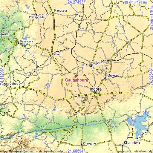
| \ | Map #1 | Map #2 | Topo.Map |
| Scale [m] | 481..520 m | 477..530 m | × |
| Scale [ft] | 1578..1706 ft | 1565..1739 ft | × |
| Average | 500.9 m = 1643 ft | 505.5 m = 1658 ft | × |
| Width | 9 km = 5.6 mi | 17.99 km = 11.2 mi | 287.9 km = 178.9 mi |
| Height | 9 km = 5.6 mi | 17.99 km = 11.2 mi | 287.9 km = 178.9 mi |
| ↑Max Latitude | 23.02709° | 23.067527° | 24.27493° |
| Latitude at center | 22.98664° | 22.98664° | 22.98664° |
| ↓Min Latitude | 22.946178° | 22.905704° | 21.68594° |
| ← Min Longitude | 75.475265° | 75.431319° | 74.11296° |
| Longitude center | 75.51921° | 75.51921° | 75.51921° |
| →Max Longitude | 75.563155° | 75.607101° | 76.92546° |
Nearby cities:
Cities around Gautampura sort by population:
• Indore elevation 550 m
43.9 km,  132°
132°
• Ujjain 494 m
34.1 km,  50°
50°
• Nagda 470 m
53.5 km,  348°
348°
• Dhār 559 m
49.2 km,  207°
207°
• Pithampur 595 m
46.5 km,  156°
156°
• Badnāwar 515 m
29.6 km,  277°
277°
• Depālpur 537 m
15.3 km,  171°
171°
• Unhel 485 m
39.3 km,  5°
5°
• Sānwer 512 m
31.5 km,  92°
92°
• Betma 548 m
34.8 km, 163°
• Hātod 540 m
31.1 km, 133°
• Piploda 469 m
41.3 km, 347°
Multilingual:
 En español:
Gautampura elevación 502 m.
 En France:
Gautampura élévation 502 m.
 Auf Deutsch:
Gautampura höhe über dem Meeresspiegel ist 502 m.

Sources and notes:
- [note 1] Map square and city borders are not equal. Map elevation data is calculated only from area inside that square.
- [src 1] Elevation data from geonames database provided with same terms of usage.
- [src 2] The elevation map of Gautampura is generated using elevation data from NASA's 3 arcsec (90m) resolution SRTM data.
- [src 3] Base (background) map © OpenStreetMap contributors tiles are generated by Geofabrik and OpenTopoMap.
Copyright & License:
This Gautampura Elevation Map is licensed under CC BY-SA. You may reuse any part from this page, if you give a proper credit by linking to this URL:
 More info on terms of use page.