Hindaun elevation
Hindaun (Rajasthan, Karauli), India elevation is 231 meters and Hindaun elevation in feet is 758 ft above sea level [src 1]. Hindaun is a populated place (feature code) with elevation that is 62 meters (203 ft) smaller than average city elevation in India.
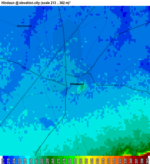
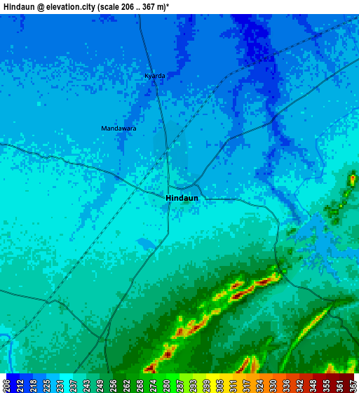
Below is the Elevation map of Hindaun, which displays elevation range with different colors. Scale of the first map is from 213 to 362 m (699 to 1188 ft) with average elevation of 232.7 meters (=763 ft) [note 1]
These maps also provides idea of topography and contour of this city, they are displayed at different zoom levels. More info about maps, scale and edge coordinates you can find below images.
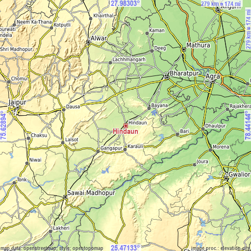
| \ | Map #1 | Map #2 | Topo.Map |
| Scale [m] | 213..362 m | 206..367 m | × |
| Scale [ft] | 699..1188 ft | 676..1204 ft | × |
| Average | 232.7 m = 763 ft | 235.7 m = 773 ft | × |
| Width | 8.73 km = 5.4 mi | 17.46 km = 10.8 mi | 279.3 km = 173.5 mi |
| Height | 8.73 km = 5.4 mi | 17.46 km = 10.8 mi | 279.3 km = 173.5 mi |
| ↑Max Latitude | 26.773351° | 26.812578° | 27.98303° |
| Latitude at center | 26.73411° | 26.73411° | 26.73411° |
| ↓Min Latitude | 26.694856° | 26.655587° | 25.47133° |
| ← Min Longitude | 76.991245° | 76.947299° | 75.62894° |
| Longitude center | 77.03519° | 77.03519° | 77.03519° |
| →Max Longitude | 77.079135° | 77.123081° | 78.44144° |
Nearby cities:
Cities around Hindaun sort by population:
• Gangāpur elevation 262 m
42.9 km,  227°
227°
• Karauli 272 m
26.2 km,  181°
181°
• Bāri 210 m
58.5 km,  99°
99°
• Bayāna 210 m
31.8 km,  52°
52°
• Nādbai 201 m
56.6 km,  16°
16°
• Mahwah 237 m
36.2 km,  343°
343°
• Todabhim 252 m
29.7 km,  313°
313°
• Bhasāwar 221 m
33.9 km,  2°
2°
• Wer 222 m
34.6 km, 23°
• Bāndīkūi 283 m
57.8 km, 307°
• Jagnair 186 m
58.1 km,  75°
75°
• Abhaneri 280 m
52.2 km, 305°
Multilingual:
 En español:
Hindaun elevación 231 m.
 En France:
Hindaun élévation 231 m.


Sources and notes:
- [note 1] Map square and city borders are not equal. Map elevation data is calculated only from area inside that square.
- [src 1] Elevation data from geonames database provided with same terms of usage.
- [src 2] The elevation map of Hindaun is generated using elevation data from NASA's 3 arcsec (90m) resolution SRTM data.
- [src 3] Base (background) map © OpenStreetMap contributors tiles are generated by Geofabrik and OpenTopoMap.
Copyright & License:
This Hindaun Elevation Map is licensed under CC BY-SA. You may reuse any part from this page, if you give a proper credit by linking to this URL:
 More info on terms of use page.