Jagnair elevation
Jagnair (Uttar Pradesh, Āgra), India elevation is 186 meters and Jagnair elevation in feet is 610 ft above sea level [src 1]. Jagnair is a populated place (feature code) with elevation that is 107 meters (351 ft) smaller than average city elevation in India.
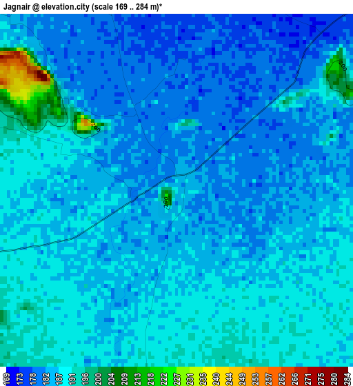
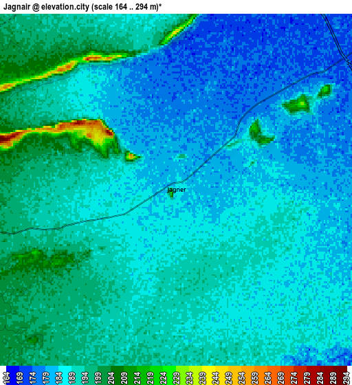
Below is the Elevation map of Jagnair, which displays elevation range with different colors. Scale of the first map is from 169 to 284 m (554 to 932 ft) with average elevation of 186.1 meters (=611 ft) [note 1]
These maps also provides idea of topography and contour of this city, they are displayed at different zoom levels. More info about maps, scale and edge coordinates you can find below images.
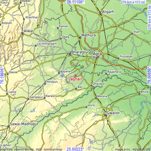
| \ | Map #1 | Map #2 | Topo.Map |
| Scale [m] | 169..284 m | 164..294 m | × |
| Scale [ft] | 554..932 ft | 538..965 ft | × |
| Average | 186.1 m = 611 ft | 188.3 m = 618 ft | × |
| Width | 8.72 km = 5.4 mi | 17.44 km = 10.8 mi | 279 km = 173.4 mi |
| Height | 8.72 km = 5.4 mi | 17.44 km = 10.8 mi | 279 km = 173.4 mi |
| ↑Max Latitude | 26.902796° | 26.941979° | 28.11106° |
| Latitude at center | 26.8636° | 26.8636° | 26.8636° |
| ↓Min Latitude | 26.82439° | 26.785167° | 25.60223° |
| ← Min Longitude | 77.558365° | 77.514419° | 76.19606° |
| Longitude center | 77.60231° | 77.60231° | 77.60231° |
| →Max Longitude | 77.646255° | 77.690201° | 79.00856° |
Nearby cities:
Cities around Jagnair sort by population:
• Agra elevation 166 m
54.3 km,  49°
49°
• Bharatpur 180 m
40.9 km,  344°
344°
• Dhaulpur 173 m
33.4 km,  124°
124°
• Bāri 210 m
24.2 km,  176°
176°
• Bayāna 210 m
31.4 km,  279°
279°
• Shamsābād 170 m
54.4 km,  71°
71°
• Fatehpur Sīkri 213 m
26.2 km,  12°
12°
• Kiraoli 177 m
35.5 km,  30°
30°
• Achhnera 176 m
38.2 km,  23°
23°
• Khairāgarh 171 m
23.2 km, 67°
• Wer 222 m
45.6 km,  292°
292°
• Farah 179 m
53.2 km, 17°
Multilingual:
 En español:
Jagnair elevación 186 m.
 En France:
Jagnair élévation 186 m.


Sources and notes:
- [note 1] Map square and city borders are not equal. Map elevation data is calculated only from area inside that square.
- [src 1] Elevation data from geonames database provided with same terms of usage.
- [src 2] The elevation map of Jagnair is generated using elevation data from NASA's 3 arcsec (90m) resolution SRTM data.
- [src 3] Base (background) map © OpenStreetMap contributors tiles are generated by Geofabrik and OpenTopoMap.
Copyright & License:
This Jagnair Elevation Map is licensed under CC BY-SA. You may reuse any part from this page, if you give a proper credit by linking to this URL:
 More info on terms of use page.