Islāmpur elevation
Islāmpur (West Bengal, Uttar Dinajpur), India elevation is 70 meters and Islāmpur elevation in feet is 230 ft above sea level [src 1]. Islāmpur is a populated place (feature code) with elevation that is 223 meters (732 ft) smaller than average city elevation in India.
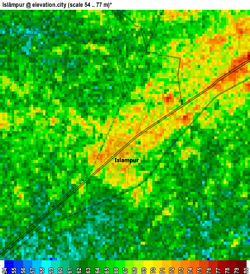
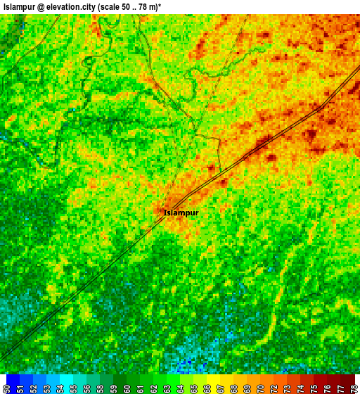
Below is the Elevation map of Islāmpur, which displays elevation range with different colors. Scale of the first map is from 54 to 77 m (177 to 253 ft) with average elevation of 64.9 meters (=213 ft) [note 1]
These maps also provides idea of topography and contour of this city, they are displayed at different zoom levels. More info about maps, scale and edge coordinates you can find below images.
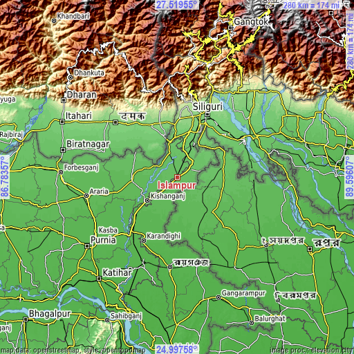
| \ | Map #1 | Map #2 | Topo.Map |
| Scale [m] | 54..77 m | 50..78 m | × |
| Scale [ft] | 177..253 ft | 164..256 ft | × |
| Average | 64.9 m = 213 ft | 63.9 m = 210 ft | × |
| Width | 8.76 km = 5.4 mi | 17.53 km = 10.9 mi | 280.4 km = 174.2 mi |
| Height | 8.76 km = 5.4 mi | 17.53 km = 10.9 mi | 280.4 km = 174.2 mi |
| ↑Max Latitude | 26.304811° | 26.344199° | 27.51955° |
| Latitude at center | 26.26541° | 26.26541° | 26.26541° |
| ↓Min Latitude | 26.225995° | 26.186567° | 24.99758° |
| ← Min Longitude | 88.145875° | 88.101929° | 86.78357° |
| Longitude center | 88.18982° | 88.18982° | 88.18982° |
| →Max Longitude | 88.233765° | 88.277711° | 89.59607° |
Nearby cities:
Cities around Islāmpur sort by population:
• Siliguri elevation 124 m
54.8 km,  25°
25°
• Jalpāiguri 87 m
60.9 km,  62°
62°
• Kishanganj 57 m
29.6 km,  232°
232°
• Arāria 56 m
68.7 km,  259°
259°
• Naksalbāri 165 m
46.5 km,  3°
3°
• Bahādurganj 57 m
36.4 km,  269°
269°
• Bagdogra 149 m
49.7 km,  14°
14°
• Thākurganj 80 m
18.9 km,  342°
342°
• Dalkola 44 m
55.7 km,  218°
218°
• Haldībāri 76 m
59.6 km,  82°
82°
• Mirik 1642 m
69.2 km, 0°
• Baisi 42 m
63.1 km, 224°
Multilingual:
 En español:
Islāmpur elevación 70 m.
 En France:
Islāmpur élévation 70 m.


Sources and notes:
- [note 1] Map square and city borders are not equal. Map elevation data is calculated only from area inside that square.
- [src 1] Elevation data from geonames database provided with same terms of usage.
- [src 2] The elevation map of Islāmpur is generated using elevation data from NASA's 3 arcsec (90m) resolution SRTM data.
- [src 3] Base (background) map © OpenStreetMap contributors tiles are generated by Geofabrik and OpenTopoMap.
Copyright & License:
This Islāmpur Elevation Map is licensed under CC BY-SA. You may reuse any part from this page, if you give a proper credit by linking to this URL:
 More info on terms of use page.