Naksalbāri elevation
Naksalbāri (West Bengal, Darjiling), India elevation is 165 meters and Naksalbāri elevation in feet is 541 ft above sea level [src 1]. Naksalbāri is a populated place (feature code) with elevation that is 128 meters (420 ft) smaller than average city elevation in India.
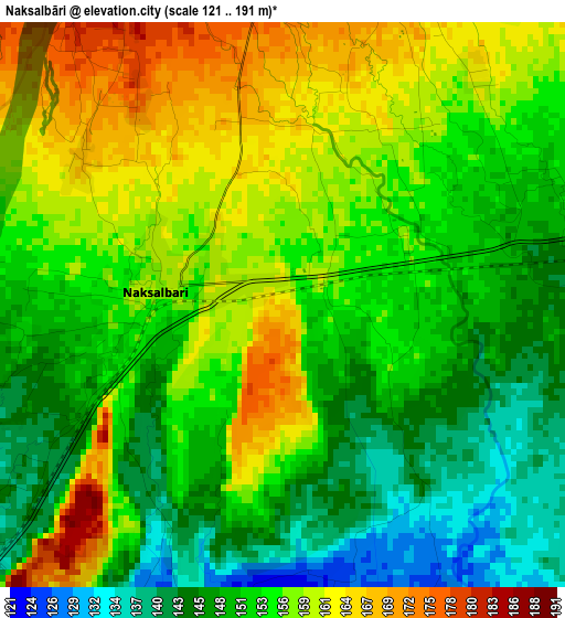
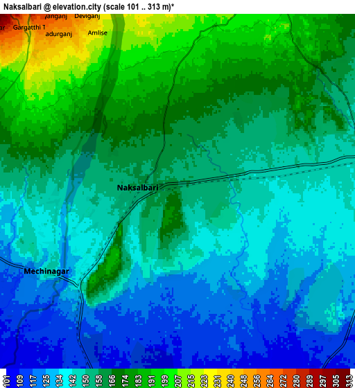
Below is the Elevation map of Naksalbāri, which displays elevation range with different colors. Scale of the first map is from 121 to 191 m (397 to 627 ft) with average elevation of 153.8 meters (=505 ft) [note 1]
These maps also provides idea of topography and contour of this city, they are displayed at different zoom levels. More info about maps, scale and edge coordinates you can find below images.
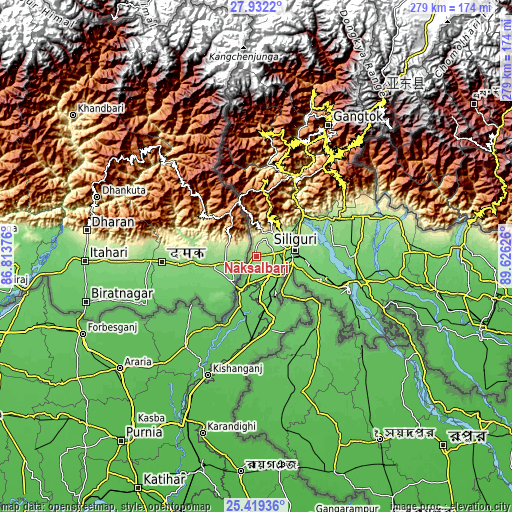
| \ | Map #1 | Map #2 | Topo.Map |
| Scale [m] | 121..191 m | 101..313 m | × |
| Scale [ft] | 397..627 ft | 331..1027 ft | × |
| Average | 153.8 m = 505 ft | 154.3 m = 506 ft | × |
| Width | 8.73 km = 5.4 mi | 17.46 km = 10.8 mi | 279.4 km = 173.6 mi |
| Height | 8.73 km = 5.4 mi | 17.46 km = 10.8 mi | 279.4 km = 173.6 mi |
| ↑Max Latitude | 26.721959° | 26.761204° | 27.9322° |
| Latitude at center | 26.6827° | 26.6827° | 26.6827° |
| ↓Min Latitude | 26.643428° | 26.604142° | 25.41936° |
| ← Min Longitude | 88.176065° | 88.132119° | 86.81376° |
| Longitude center | 88.22001° | 88.22001° | 88.22001° |
| →Max Longitude | 88.263955° | 88.307901° | 89.62626° |
Nearby cities:
Cities around Naksalbāri sort by population:
• Siliguri elevation 124 m
20.9 km,  81°
81°
• Dārjiling 2127 m
39.3 km,  6°
6°
• Islāmpur 70 m
46.5 km,  183°
183°
• Kārsiyāng 1501 m
22.9 km, 14°
• Kālimpong 1141 m
50 km,  30°
30°
• Bagdogra 149 m
9.3 km, 78°
• Thākurganj 80 m
29.7 km,  197°
197°
• Odlābāri 147 m
44.1 km,  67°
67°
• Mirik 1642 m
23 km,  352°
352°
• Jorethang 290 m
48.3 km, 12°
• Naya Bāzār 927 m
49.9 km,  2°
2°
• Kalimpong, Крукети 1340 m
48 km, 30°
Multilingual:
 En español:
Naksalbāri elevación 165 m.
 En France:
Naksalbāri élévation 165 m.
 Auf Deutsch:
Naksalbāri höhe über dem Meeresspiegel ist 165 m.

Sources and notes:
- [note 1] Map square and city borders are not equal. Map elevation data is calculated only from area inside that square.
- [src 1] Elevation data from geonames database provided with same terms of usage.
- [src 2] The elevation map of Naksalbāri is generated using elevation data from NASA's 3 arcsec (90m) resolution SRTM data.
- [src 3] Base (background) map © OpenStreetMap contributors tiles are generated by Geofabrik and OpenTopoMap.
Copyright & License:
This Naksalbāri Elevation Map is licensed under CC BY-SA. You may reuse any part from this page, if you give a proper credit by linking to this URL:
 More info on terms of use page.