Jetpur elevation
Jetpur (Gujarat, Vadodara), India elevation is 106 meters and Jetpur elevation in feet is 348 ft above sea level [src 1]. Jetpur is a populated place (feature code) with elevation that is 187 meters (614 ft) smaller than average city elevation in India.
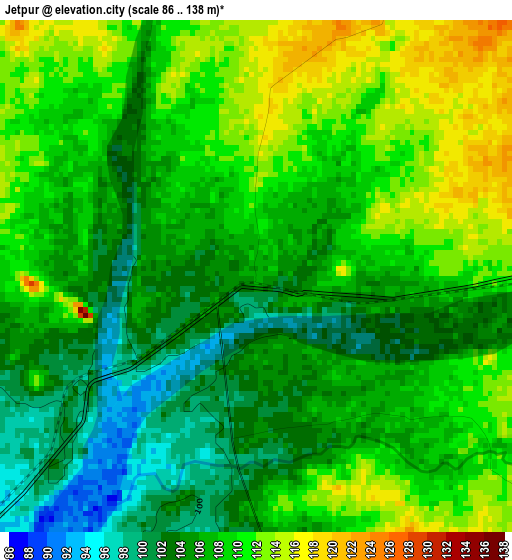
Below is the Elevation map of Jetpur, which displays elevation range with different colors. Scale of the first map is from 86 to 138 m (282 to 453 ft) with average elevation of 107.3 meters (=352 ft) [note 1]
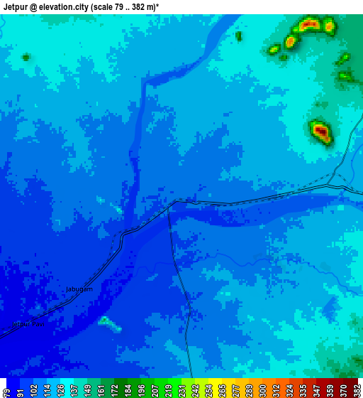
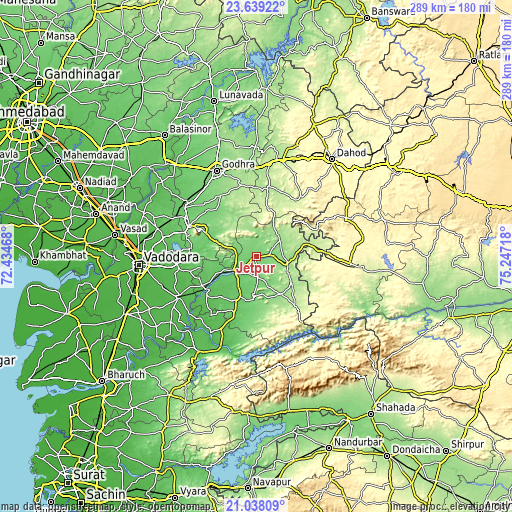
These maps also provides idea of topography and contour of this city, they are displayed at different zoom levels. More info about maps, scale and edge coordinates you can find below images.
| \ | Map #1 | Map #2 | Topo.Map |
| Scale [m] | 86..138 m | 79..382 m | × |
| Scale [ft] | 282..453 ft | 259..1253 ft | × |
| Average | 107.3 m = 352 ft | 115.7 m = 380 ft | × |
| Width | 9.04 km = 5.6 mi | 18.08 km = 11.2 mi | 289.2 km = 179.7 mi |
| Height | 9.04 km = 5.6 mi | 18.08 km = 11.2 mi | 289.2 km = 179.7 mi |
| ↑Max Latitude | 22.38536° | 22.425987° | 23.63922° |
| Latitude at center | 22.34472° | 22.34472° | 22.34472° |
| ↓Min Latitude | 22.304068° | 22.263405° | 21.03809° |
| ← Min Longitude | 73.796985° | 73.753039° | 72.43468° |
| Longitude center | 73.84093° | 73.84093° | 73.84093° |
| →Max Longitude | 73.884875° | 73.928821° | 75.24718° |
Nearby cities:
Cities around Jetpur sort by population:
• Godhra elevation 132 m
53.2 km,  334°
334°
• Vejalpur 113 m
47.9 km,  323°
323°
• Dabhoi 46 m
45.6 km,  246°
246°
• Hālol 109 m
41.8 km,  294°
294°
• Rajpur 288 m
53.1 km,  94°
94°
• Kālol 88 m
48.6 km,  306°
306°
• Chhota Udepur 150 m
18.5 km,  104°
104°
• Devgadh Bāriya 201 m
40.7 km,  9°
9°
• Vāghodia 54 m
45.5 km,  264°
264°
• Sankheda 68 m
33.3 km,  234°
234°
• Kawānt 200 m
35.4 km,  142°
142°
• Shivrājpur 106 m
25.4 km, 290°
Multilingual:
 En español:
Jetpur elevación 106 m.
 En France:
Jetpur élévation 106 m.


Sources and notes:
- [note 1] Map square and city borders are not equal. Map elevation data is calculated only from area inside that square.
- [src 1] Elevation data from geonames database provided with same terms of usage.
- [src 2] The elevation map of Jetpur is generated using elevation data from NASA's 3 arcsec (90m) resolution SRTM data.
- [src 3] Base (background) map © OpenStreetMap contributors tiles are generated by Geofabrik and OpenTopoMap.
Copyright & License:
This Jetpur Elevation Map is licensed under CC BY-SA. You may reuse any part from this page, if you give a proper credit by linking to this URL:
 More info on terms of use page.