Kawānt elevation
Kawānt (Gujarat, Vadodara), India elevation is 200 meters and Kawānt elevation in feet is 656 ft above sea level [src 1]. Kawānt is a populated place (feature code) with elevation that is 93 meters (305 ft) smaller than average city elevation in India.
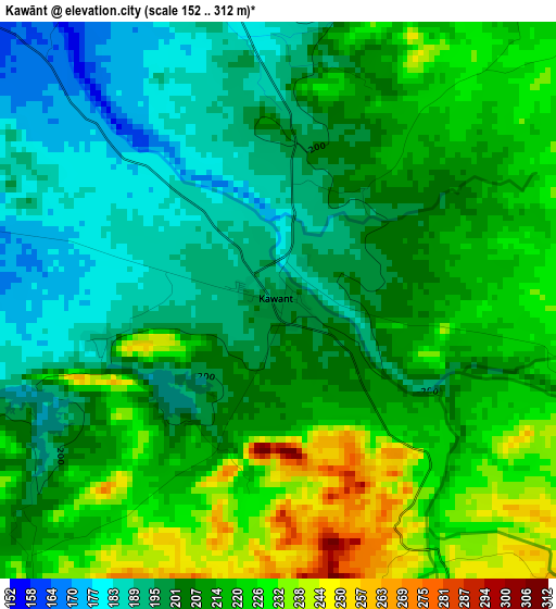
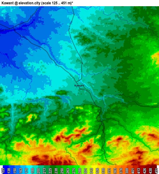
Below is the Elevation map of Kawānt, which displays elevation range with different colors. Scale of the first map is from 152 to 312 m (499 to 1024 ft) with average elevation of 209.3 meters (=687 ft) [note 1]
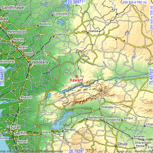
These maps also provides idea of topography and contour of this city, they are displayed at different zoom levels. More info about maps, scale and edge coordinates you can find below images.
| \ | Map #1 | Map #2 | Topo.Map |
| Scale [m] | 152..312 m | 125..451 m | × |
| Scale [ft] | 499..1024 ft | 410..1480 ft | × |
| Average | 209.3 m = 687 ft | 231.7 m = 760 ft | × |
| Width | 9.05 km = 5.6 mi | 18.11 km = 11.3 mi | 289.7 km = 180 mi |
| Height | 9.06 km = 5.6 mi | 18.11 km = 11.3 mi | 289.8 km = 180.1 mi |
| ↑Max Latitude | 22.133533° | 22.174234° | 23.38971° |
| Latitude at center | 22.09282° | 22.09282° | 22.09282° |
| ↓Min Latitude | 22.052095° | 22.011359° | 20.7839° |
| ← Min Longitude | 74.006835° | 73.962889° | 72.64453° |
| Longitude center | 74.05078° | 74.05078° | 74.05078° |
| →Max Longitude | 74.094725° | 74.138671° | 75.45703° |
Nearby cities:
Cities around Kawānt sort by population:
• Dabhoi elevation 46 m
64.4 km,  278°
278°
• Rājpīpla 45 m
62.1 km,  246°
246°
• Rajpur 288 m
39.2 km,  53°
53°
• Taloda 126 m
61.4 km,  164°
164°
• Chhota Udepur 150 m
23.8 km,  351°
351°
• Devgadh Bāriya 201 m
69.6 km, 347°
• Vāghodia 54 m
71 km,  289°
289°
• Sankheda 68 m
49.4 km, 280°
• Jobat 305 m
64.2 km,  55°
55°
• Bhābhra 369 m
56.4 km,  30°
30°
• Jetpur 106 m
35.4 km,  322°
322°
• Shivrājpur 106 m
58.5 km,  308°
308°
Multilingual:
 En español:
Kawānt elevación 200 m.
 En France:
Kawānt élévation 200 m.


Sources and notes:
- [note 1] Map square and city borders are not equal. Map elevation data is calculated only from area inside that square.
- [src 1] Elevation data from geonames database provided with same terms of usage.
- [src 2] The elevation map of Kawānt is generated using elevation data from NASA's 3 arcsec (90m) resolution SRTM data.
- [src 3] Base (background) map © OpenStreetMap contributors tiles are generated by Geofabrik and OpenTopoMap.
Copyright & License:
This Kawānt Elevation Map is licensed under CC BY-SA. You may reuse any part from this page, if you give a proper credit by linking to this URL:
 More info on terms of use page.