Jhajjar elevation
Jhajjar (Haryana), India elevation is 224 meters and Jhajjar elevation in feet is 735 ft above sea level [src 1]. Jhajjar is a populated place (feature code) with elevation that is 69 meters (226 ft) smaller than average city elevation in India.
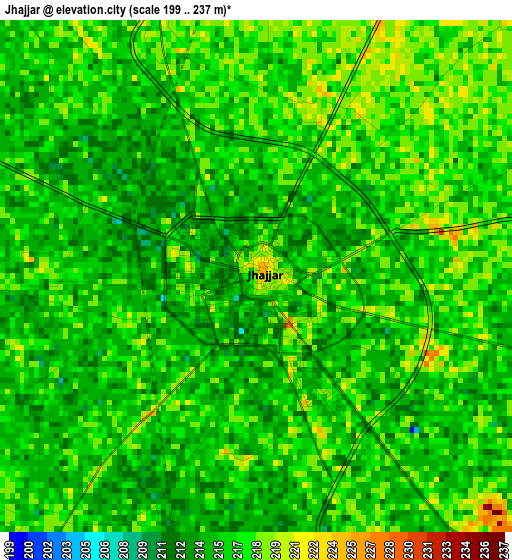
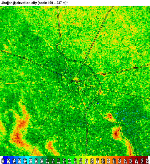
Below is the Elevation map of Jhajjar, which displays elevation range with different colors. Scale of the first map is from 199 to 237 m (653 to 778 ft) with average elevation of 215.9 meters (=708 ft) [note 1]
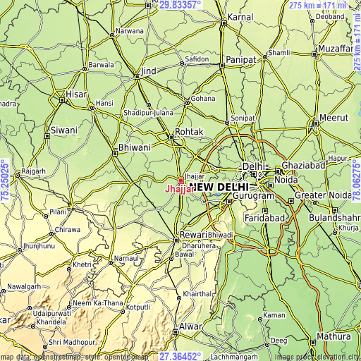
These maps also provides idea of topography and contour of this city, they are displayed at different zoom levels. More info about maps, scale and edge coordinates you can find below images.
| \ | Map #1 | Map #2 | Topo.Map |
| Scale [m] | 199..237 m | 199..237 m | × |
| Scale [ft] | 653..778 ft | 653..778 ft | × |
| Average | 215.9 m = 708 ft | 216.6 m = 711 ft | × |
| Width | 8.58 km = 5.3 mi | 17.16 km = 10.7 mi | 274.5 km = 170.6 mi |
| Height | 8.58 km = 5.3 mi | 17.16 km = 10.7 mi | 274.5 km = 170.6 mi |
| ↑Max Latitude | 28.644874° | 28.683433° | 29.83357° |
| Latitude at center | 28.6063° | 28.6063° | 28.6063° |
| ↓Min Latitude | 28.567712° | 28.52911° | 27.36452° |
| ← Min Longitude | 76.612555° | 76.568609° | 75.25025° |
| Longitude center | 76.6565° | 76.6565° | 76.6565° |
| →Max Longitude | 76.700445° | 76.744391° | 78.06275° |
Nearby cities:
Cities around Jhajjar sort by population:
• Najafgarh elevation 215 m
31.6 km,  89°
89°
• Rohtak 222 m
32.7 km,  348°
348°
• Gurgaon 228 m
39.6 km,  114°
114°
• Nāngloi Jāt 218 m
41 km,  78°
78°
• Bahādurgarh 215 m
28.9 km,  70°
70°
• Charkhi Dādri 225 m
37.6 km,  267°
267°
• Kharkhauda 227 m
39.1 km,  39°
39°
• Pataudi 235 m
33.4 km,  159°
159°
• Kalānaur 227 m
35.4 km,  314°
314°
• Beri Khās 226 m
13.1 km,  323°
323°
• Kheri Sāmpla 223 m
22.4 km,  31°
31°
• Farrukhnagar 222 m
24.1 km,  137°
137°
Multilingual:
 En español:
Jhajjar elevación 224 m.
 En France:
Jhajjar élévation 224 m.


Sources and notes:
- [note 1] Map square and city borders are not equal. Map elevation data is calculated only from area inside that square.
- [src 1] Elevation data from geonames database provided with same terms of usage.
- [src 2] The elevation map of Jhajjar is generated using elevation data from NASA's 3 arcsec (90m) resolution SRTM data.
- [src 3] Base (background) map © OpenStreetMap contributors tiles are generated by Geofabrik and OpenTopoMap.
Copyright & License:
This Jhajjar Elevation Map is licensed under CC BY-SA. You may reuse any part from this page, if you give a proper credit by linking to this URL:
 More info on terms of use page.