Jodhpur elevation
Jodhpur (Gujarat, Jāmnagar), India elevation is 99 meters and Jodhpur elevation in feet is 325 ft above sea level [src 1]. Jodhpur is a populated place (feature code) with elevation that is 194 meters (636 ft) smaller than average city elevation in India.
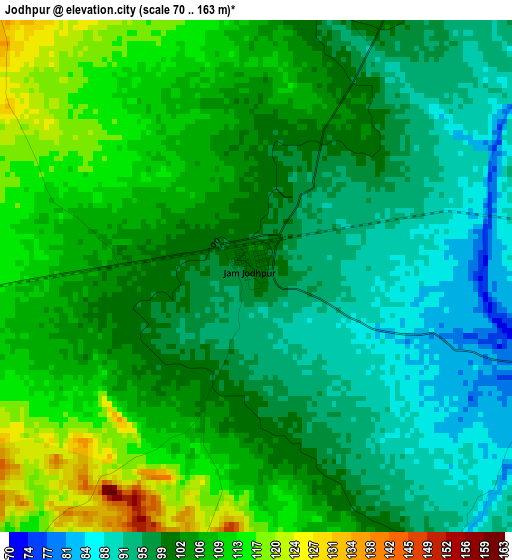
Below is the Elevation map of Jodhpur, which displays elevation range with different colors. Scale of the first map is from 70 to 163 m (230 to 535 ft) with average elevation of 102.3 meters (=336 ft) [note 1]
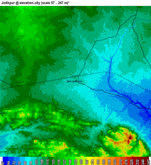
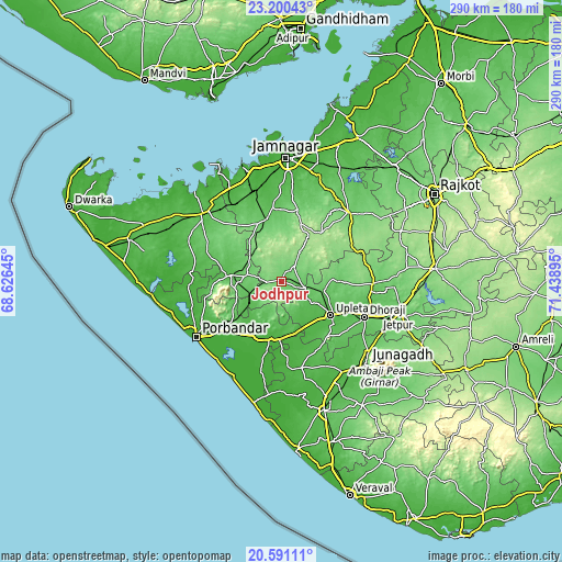
These maps also provides idea of topography and contour of this city, they are displayed at different zoom levels. More info about maps, scale and edge coordinates you can find below images.
| \ | Map #1 | Map #2 | Topo.Map |
| Scale [m] | 70..163 m | 57..247 m | × |
| Scale [ft] | 230..535 ft | 187..810 ft | × |
| Average | 102.3 m = 336 ft | 111.9 m = 367 ft | × |
| Width | 9.07 km = 5.6 mi | 18.13 km = 11.3 mi | 290.1 km = 180.3 mi |
| Height | 9.07 km = 5.6 mi | 18.13 km = 11.3 mi | 290.1 km = 180.3 mi |
| ↑Max Latitude | 21.942508° | 21.983264° | 23.20043° |
| Latitude at center | 21.90174° | 21.90174° | 21.90174° |
| ↓Min Latitude | 21.860961° | 21.82017° | 20.59111° |
| ← Min Longitude | 69.988755° | 69.944809° | 68.62645° |
| Longitude center | 70.0327° | 70.0327° | 70.0327° |
| →Max Longitude | 70.076645° | 70.120591° | 71.43895° |
Nearby cities:
Cities around Jodhpur sort by population:
• Porbandar elevation 7 m
52.4 km,  236°
236°
• Dhorāji 63 m
47 km,  113°
113°
• Upleta 43 m
31.4 km,  124°
124°
• Khambhāliya 50 m
52 km,  310°
310°
• Mānāvadar 29 m
46.2 km,  166°
166°
• Kālāvad 100 m
49.7 km,  46°
46°
• Rānāvāv 29 m
38.1 km,  231°
231°
• Bhānvad 55 m
26.2 km,  277°
277°
• Bhāyāvadar 86 m
22.8 km,  103°
103°
• Kutiyāna 21 m
31.3 km,  189°
189°
• Lālpur 79 m
32.9 km,  347°
347°
• Bāntva 26 m
46.2 km, 174°
Multilingual:
 En español:
Jodhpur elevación 99 m.
 En France:
Jodhpur élévation 99 m.


Sources and notes:
- [note 1] Map square and city borders are not equal. Map elevation data is calculated only from area inside that square.
- [src 1] Elevation data from geonames database provided with same terms of usage.
- [src 2] The elevation map of Jodhpur is generated using elevation data from NASA's 3 arcsec (90m) resolution SRTM data.
- [src 3] Base (background) map © OpenStreetMap contributors tiles are generated by Geofabrik and OpenTopoMap.
Copyright & License:
This Jodhpur Elevation Map is licensed under CC BY-SA. You may reuse any part from this page, if you give a proper credit by linking to this URL:
 More info on terms of use page.