Khammam elevation
Khammam (Telangana), India elevation is 120 meters and Khammam elevation in feet is 394 ft above sea level [src 1]. Khammam is a populated place (feature code) with elevation that is 173 meters (568 ft) smaller than average city elevation in India.
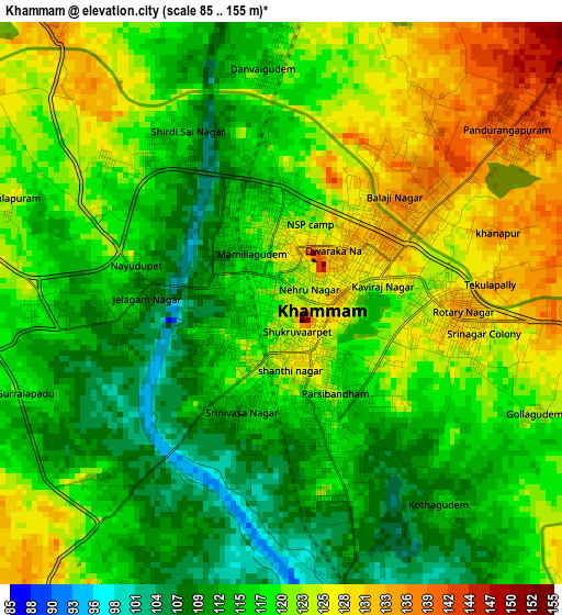
Below is the Elevation map of Khammam, which displays elevation range with different colors. Scale of the first map is from 85 to 155 m (279 to 509 ft) with average elevation of 119.1 meters (=391 ft) [note 1]
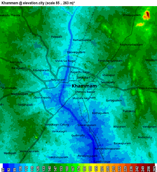
These maps also provides idea of topography and contour of this city, they are displayed at different zoom levels. More info about maps, scale and edge coordinates you can find below images.
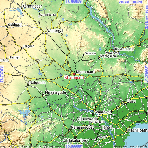
| \ | Map #1 | Map #2 | Topo.Map |
| Scale [m] | 85..155 m | 85..263 m | × |
| Scale [ft] | 279..509 ft | 279..863 ft | × |
| Average | 119.1 m = 391 ft | 129.4 m = 425 ft | × |
| Width | 9.33 km = 5.8 mi | 18.67 km = 11.6 mi | 298.6 km = 185.5 mi |
| Height | 9.33 km = 5.8 mi | 18.67 km = 11.6 mi | 298.7 km = 185.6 mi |
| ↑Max Latitude | 17.289634° | 17.331589° | 18.58569° |
| Latitude at center | 17.24767° | 17.24767° | 17.24767° |
| ↓Min Latitude | 17.205696° | 17.163713° | 15.89988° |
| ← Min Longitude | 80.099735° | 80.055789° | 78.73743° |
| Longitude center | 80.14368° | 80.14368° | 80.14368° |
| →Max Longitude | 80.187625° | 80.231571° | 81.54993° |
Nearby cities:
Cities around Khammam sort by population:
• Suriāpet elevation 177 m
56.8 km,  257°
257°
• Miriālgūda 134 m
74.6 km,  235°
235°
• Kottagūdem 115 m
60.6 km,  56°
56°
• Pāloncha 106 m
71.4 km, 56°
• Palwancha 87 m
67.6 km, 56°
• Kodār 113 m
33.6 km,  214°
214°
• Yellandu 213 m
42.5 km,  26°
26°
• Jaggayyapeta 56 m
39.6 km,  187°
187°
• Nandigāma 54 m
55 km,  164°
164°
• Mahbūbābād 198 m
41.7 km,  338°
338°
• Dornakal 153 m
21.9 km,  1°
1°
• Chātakonda 100 m
63.3 km, 57°
Multilingual:
 En español:
Khammam elevación 120 m.
 En France:
Khammam élévation 120 m.


Sources and notes:
- [note 1] Map square and city borders are not equal. Map elevation data is calculated only from area inside that square.
- [src 1] Elevation data from geonames database provided with same terms of usage.
- [src 2] The elevation map of Khammam is generated using elevation data from NASA's 3 arcsec (90m) resolution SRTM data.
- [src 3] Base (background) map © OpenStreetMap contributors tiles are generated by Geofabrik and OpenTopoMap.
Copyright & License:
This Khammam Elevation Map is licensed under CC BY-SA. You may reuse any part from this page, if you give a proper credit by linking to this URL:
 More info on terms of use page.