Kohima elevation
Kohima (Nagaland, Kohīma), India elevation is 1463 meters and Kohima elevation in feet is 4800 ft above sea level [src 1]. Kohima is a seat of a first-order administrative division (feature code) with elevation that is 1170 meters (3839 ft) bigger than average city elevation in India.
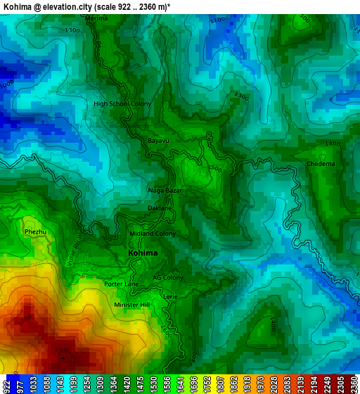
Below is the Elevation map of Kohima, which displays elevation range with different colors. Scale of the first map is from 922 to 2360 m (3025 to 7743 ft) with average elevation of 1379.2 meters (=4525 ft) [note 1]
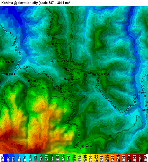
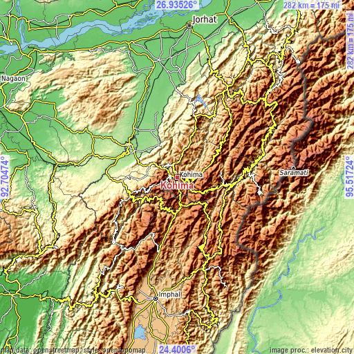
These maps also provides idea of topography and contour of this city, they are displayed at different zoom levels. More info about maps, scale and edge coordinates you can find below images.
| \ | Map #1 | Map #2 | Topo.Map |
| Scale [m] | 922..2360 m | 587..3011 m | × |
| Scale [ft] | 3025..7743 ft | 1926..9879 ft | × |
| Average | 1379.2 m = 4525 ft | 1347.5 m = 4421 ft | × |
| Width | 8.81 km = 5.5 mi | 17.62 km = 10.9 mi | 281.8 km = 175.1 mi |
| Height | 8.81 km = 5.5 mi | 17.62 km = 10.9 mi | 281.8 km = 175.1 mi |
| ↑Max Latitude | 25.71427° | 25.753857° | 26.93526° |
| Latitude at center | 25.67467° | 25.67467° | 25.67467° |
| ↓Min Latitude | 25.635057° | 25.595431° | 24.4006° |
| ← Min Longitude | 94.067045° | 94.023099° | 92.70474° |
| Longitude center | 94.11099° | 94.11099° | 94.11099° |
| →Max Longitude | 94.154935° | 94.198881° | 95.51724° |
Nearby cities:
Cities around Kohima sort by population:
• Dimāpur elevation 154 m
47 km,  304°
304°
• Diphu 200 m
70.6 km,  285°
285°
• Wokha 1385 m
49.2 km,  17°
17°
• Golāghāt 101 m
94.3 km,  350°
350°
• Mokokchūng 1250 m
83 km,  29°
29°
• Tuensang 1122 m
97.1 km,  47°
47°
• Zunheboto 1349 m
52 km, 51°
• Lumding Railway Colony 141 m
94.6 km,  275°
275°
• Bokajān 138 m
50.9 km,  319°
319°
• Phek 1696 m
39 km,  91°
91°
• Barpathār 123 m
71.6 km,  341°
341°
• Kāngpokpi 1075 m
59.7 km,  193°
193°
Multilingual:
 En español:
Kohima elevación 1463 m.
 En France:
Kohima élévation 1463 m.


Sources and notes:
- [note 1] Map square and city borders are not equal. Map elevation data is calculated only from area inside that square.
- [src 1] Elevation data from geonames database provided with same terms of usage.
- [src 2] The elevation map of Kohima is generated using elevation data from NASA's 3 arcsec (90m) resolution SRTM data.
- [src 3] Base (background) map © OpenStreetMap contributors tiles are generated by Geofabrik and OpenTopoMap.
Copyright & License:
This Kohima Elevation Map is licensed under CC BY-SA. You may reuse any part from this page, if you give a proper credit by linking to this URL:
 More info on terms of use page.