Tuensang elevation
Tuensang (Nagaland, Tuensang District), India elevation is 1122 meters and Tuensang elevation in feet is 3681 ft above sea level [src 1]. Tuensang is a populated place (feature code) with elevation that is 829 meters (2720 ft) bigger than average city elevation in India.
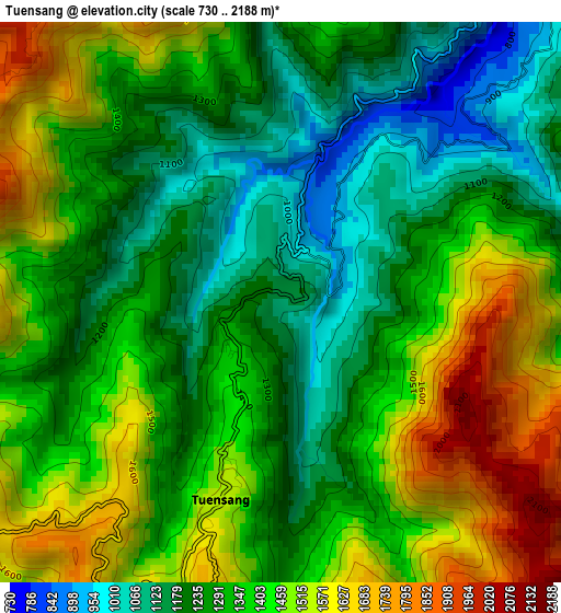
Below is the Elevation map of Tuensang, which displays elevation range with different colors. Scale of the first map is from 730 to 2188 m (2395 to 7178 ft) with average elevation of 1351.3 meters (=4433 ft) [note 1]
These maps also provides idea of topography and contour of this city, they are displayed at different zoom levels. More info about maps, scale and edge coordinates you can find below images.
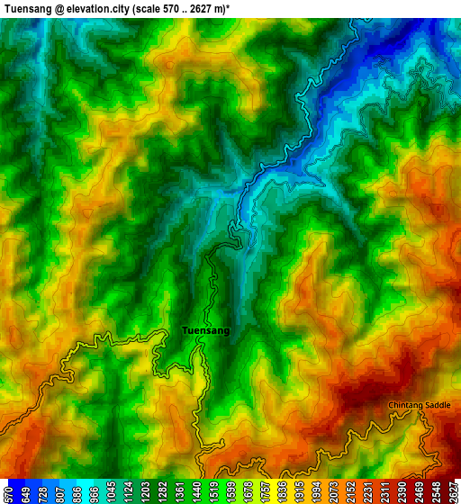
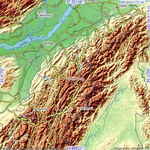
| \ | Map #1 | Map #2 | Topo.Map |
| Scale [m] | 730..2188 m | 570..2627 m | × |
| Scale [ft] | 2395..7178 ft | 1870..8619 ft | × |
| Average | 1351.3 m = 4433 ft | 1563.6 m = 5130 ft | × |
| Width | 8.76 km = 5.4 mi | 17.53 km = 10.9 mi | 280.4 km = 174.2 mi |
| Height | 8.76 km = 5.4 mi | 17.53 km = 10.9 mi | 280.4 km = 174.2 mi |
| ↑Max Latitude | 26.306441° | 26.345828° | 27.52116° |
| Latitude at center | 26.26704° | 26.26704° | 26.26704° |
| ↓Min Latitude | 26.227626° | 26.188198° | 24.99923° |
| ← Min Longitude | 94.780205° | 94.736259° | 93.4179° |
| Longitude center | 94.82415° | 94.82415° | 94.82415° |
| →Max Longitude | 94.868095° | 94.912041° | 96.2304° |
Nearby cities:
Cities around Tuensang sort by population:
• Jorhāt elevation 94 m
82.4 km,  311°
311°
• Sibsāgar 94 m
81.9 km,  346°
346°
• Wokha 1385 m
59.5 km,  251°
251°
• Mokokchūng 1250 m
31.2 km,  281°
281°
• Zunheboto 1349 m
45.4 km,  222°
222°
• Mariāni 118 m
66.7 km, 310°
• Mon 1000 m
57.1 km,  24°
24°
• Phek 1696 m
74.2 km,  205°
205°
• Nāzirā 101 m
72.7 km, 353°
• Amguri 104 m
67.7 km,  334°
334°
• Titābar 102 m
72.1 km,  301°
301°
• Longleng 1265 m
24.8 km,  358°
358°
Multilingual:
 En español:
Tuensang elevación 1122 m.
 En France:
Tuensang élévation 1122 m.
 Auf Deutsch:
Tuensang höhe über dem Meeresspiegel ist 1122 m.

Sources and notes:
- [note 1] Map square and city borders are not equal. Map elevation data is calculated only from area inside that square.
- [src 1] Elevation data from geonames database provided with same terms of usage.
- [src 2] The elevation map of Tuensang is generated using elevation data from NASA's 3 arcsec (90m) resolution SRTM data.
- [src 3] Base (background) map © OpenStreetMap contributors tiles are generated by Geofabrik and OpenTopoMap.
Copyright & License:
This Tuensang Elevation Map is licensed under CC BY-SA. You may reuse any part from this page, if you give a proper credit by linking to this URL:
 More info on terms of use page.