Kurāra elevation
Kurāra (Uttar Pradesh, Hamīrpur), India elevation is 133 meters and Kurāra elevation in feet is 436 ft above sea level [src 1]. Kurāra is a populated place (feature code) with elevation that is 160 meters (525 ft) smaller than average city elevation in India.
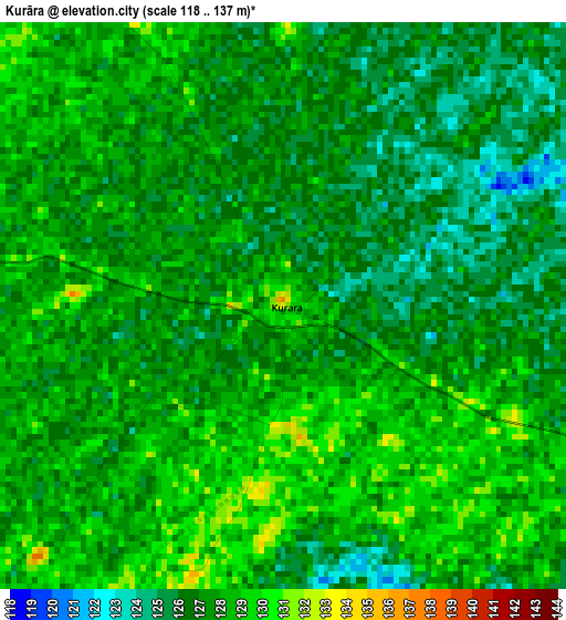
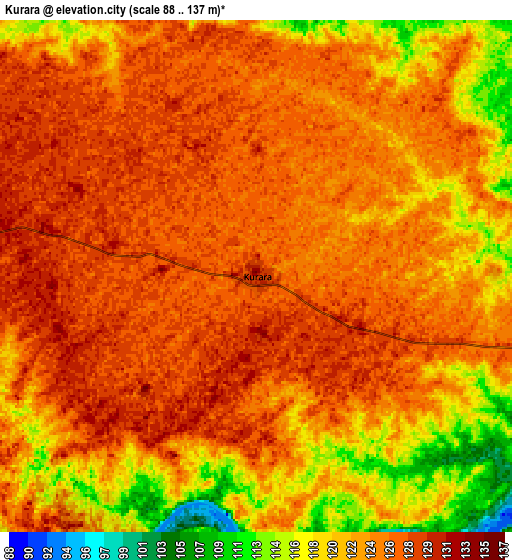
Below is the Elevation map of Kurāra, which displays elevation range with different colors. Scale of the first map is from 118 to 137 m (387 to 449 ft) with average elevation of 127.1 meters (=417 ft) [note 1]
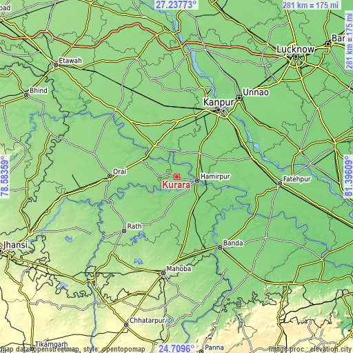
These maps also provides idea of topography and contour of this city, they are displayed at different zoom levels. More info about maps, scale and edge coordinates you can find below images.
| \ | Map #1 | Map #2 | Topo.Map |
| Scale [m] | 118..137 m | 88..137 m | × |
| Scale [ft] | 387..449 ft | 289..449 ft | × |
| Average | 127.1 m = 417 ft | 123.7 m = 406 ft | × |
| Width | 8.78 km = 5.5 mi | 17.57 km = 10.9 mi | 281.1 km = 174.7 mi |
| Height | 8.78 km = 5.5 mi | 17.57 km = 10.9 mi | 281.1 km = 174.7 mi |
| ↑Max Latitude | 26.019958° | 26.059442° | 27.23773° |
| Latitude at center | 25.98046° | 25.98046° | 25.98046° |
| ↓Min Latitude | 25.940949° | 25.901425° | 24.7096° |
| ← Min Longitude | 79.945895° | 79.901949° | 78.58359° |
| Longitude center | 79.98984° | 79.98984° | 79.98984° |
| →Max Longitude | 80.033785° | 80.077731° | 81.39609° |
Nearby cities:
Cities around Kurāra sort by population:
• Orai elevation 141 m
53.6 km,  271°
271°
• Kālpi 128 m
29.8 km,  300°
300°
• Ghātampur 128 m
26.1 km,  42°
42°
• Maudaha 127 m
35.3 km,  159°
159°
• Hamīrpur 115 m
16.1 km,  100°
100°
• Pukhrāyān 133 m
31 km,  330°
330°
• Akbarpur 135 m
45 km,  354°
354°
• Kharela 160 m
51.8 km,  200°
200°
• Kadaura 137 m
15.1 km, 272°
• Sikandra 141 m
56 km,  320°
320°
• Sarīla 148 m
38.8 km,  234°
234°
• Gohānd 153 m
54.4 km, 234°
Multilingual:
 En español:
Kurāra elevación 133 m.
 En France:
Kurāra élévation 133 m.


Sources and notes:
- [note 1] Map square and city borders are not equal. Map elevation data is calculated only from area inside that square.
- [src 1] Elevation data from geonames database provided with same terms of usage.
- [src 2] The elevation map of Kurāra is generated using elevation data from NASA's 3 arcsec (90m) resolution SRTM data.
- [src 3] Base (background) map © OpenStreetMap contributors tiles are generated by Geofabrik and OpenTopoMap.
Copyright & License:
This Kurāra Elevation Map is licensed under CC BY-SA. You may reuse any part from this page, if you give a proper credit by linking to this URL:
 More info on terms of use page.