Pukhrāyān elevation
Pukhrāyān (Uttar Pradesh, Kanpur Dehat), India elevation is 133 meters and Pukhrāyān elevation in feet is 436 ft above sea level [src 1]. Pukhrāyān is a populated place (feature code) with elevation that is 160 meters (525 ft) smaller than average city elevation in India.
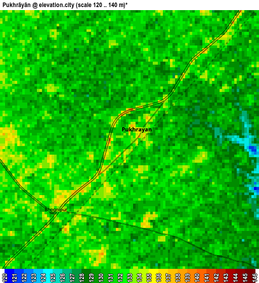
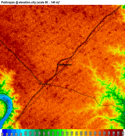
Below is the Elevation map of Pukhrāyān, which displays elevation range with different colors. Scale of the first map is from 120 to 140 m (394 to 459 ft) with average elevation of 130.6 meters (=428 ft) [note 1]
These maps also provides idea of topography and contour of this city, they are displayed at different zoom levels. More info about maps, scale and edge coordinates you can find below images.
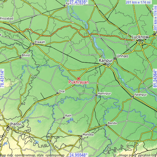
| \ | Map #1 | Map #2 | Topo.Map |
| Scale [m] | 120..140 m | 90..140 m | × |
| Scale [ft] | 394..459 ft | 295..459 ft | × |
| Average | 130.6 m = 428 ft | 128.8 m = 423 ft | × |
| Width | 8.77 km = 5.4 mi | 17.53 km = 10.9 mi | 280.5 km = 174.3 mi |
| Height | 8.77 km = 5.4 mi | 17.53 km = 10.9 mi | 280.5 km = 174.3 mi |
| ↑Max Latitude | 26.263166° | 26.302568° | 27.47835° |
| Latitude at center | 26.22375° | 26.22375° | 26.22375° |
| ↓Min Latitude | 26.184321° | 26.144879° | 24.95548° |
| ← Min Longitude | 79.793445° | 79.749499° | 78.43114° |
| Longitude center | 79.83739° | 79.83739° | 79.83739° |
| →Max Longitude | 79.881335° | 79.925281° | 81.24364° |
Nearby cities:
Cities around Pukhrāyān sort by population:
• Orai elevation 141 m
46.3 km,  235°
235°
• Auraiya 144 m
42.3 km,  309°
309°
• Jālaun 151 m
50.7 km,  260°
260°
• Kālpi 128 m
15.8 km,  221°
221°
• Ghātampur 128 m
33.9 km,  103°
103°
• Hamīrpur 115 m
43.1 km,  133°
133°
• Jhīnjhak 142 m
38.9 km,  344°
344°
• Akbarpur 135 m
21 km,  32°
32°
• Rura 140 m
30.3 km,  12°
12°
• Kadaura 137 m
26.5 km,  179°
179°
• Kurāra 133 m
31 km,  150°
150°
• Sikandra 141 m
26.1 km, 307°
Multilingual:
 En español:
Pukhrāyān elevación 133 m.
 En France:
Pukhrāyān élévation 133 m.
 Auf Deutsch:
Pukhrāyān höhe über dem Meeresspiegel ist 133 m.

Sources and notes:
- [note 1] Map square and city borders are not equal. Map elevation data is calculated only from area inside that square.
- [src 1] Elevation data from geonames database provided with same terms of usage.
- [src 2] The elevation map of Pukhrāyān is generated using elevation data from NASA's 3 arcsec (90m) resolution SRTM data.
- [src 3] Base (background) map © OpenStreetMap contributors tiles are generated by Geofabrik and OpenTopoMap.
Copyright & License:
This Pukhrāyān Elevation Map is licensed under CC BY-SA. You may reuse any part from this page, if you give a proper credit by linking to this URL:
 More info on terms of use page.