Lunglei elevation
Lunglei (Mizoram), India elevation is 1014 meters and Lunglei elevation in feet is 3327 ft above sea level [src 1]. Lunglei is a populated place (feature code) with elevation that is 721 meters (2365 ft) bigger than average city elevation in India.
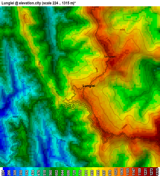
Below is the Elevation map of Lunglei, which displays elevation range with different colors. Scale of the first map is from 224 to 1315 m (735 to 4314 ft) with average elevation of 733.5 meters (=2406 ft) [note 1]
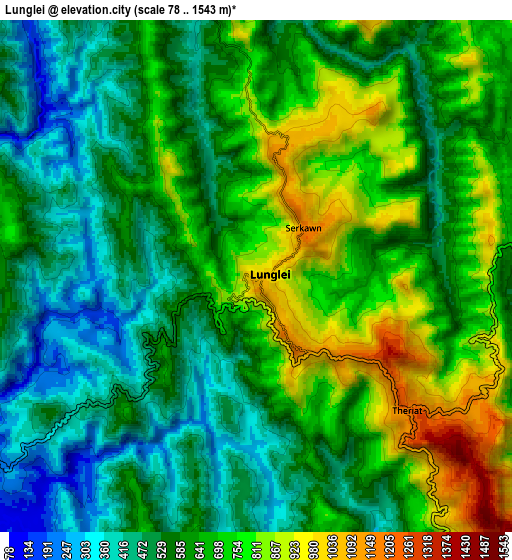
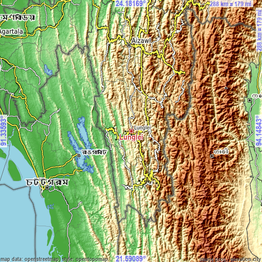
These maps also provides idea of topography and contour of this city, they are displayed at different zoom levels. More info about maps, scale and edge coordinates you can find below images.
| \ | Map #1 | Map #2 | Topo.Map |
| Scale [m] | 224..1315 m | 78..1543 m | × |
| Scale [ft] | 735..4314 ft | 256..5062 ft | × |
| Average | 733.5 m = 2406 ft | 625.4 m = 2052 ft | × |
| Width | 9 km = 5.6 mi | 18.01 km = 11.2 mi | 288.1 km = 179 mi |
| Height | 9 km = 5.6 mi | 18.01 km = 11.2 mi | 288.1 km = 179 mi |
| ↑Max Latitude | 22.932948° | 22.973414° | 24.18169° |
| Latitude at center | 22.89247° | 22.89247° | 22.89247° |
| ↓Min Latitude | 22.85198° | 22.811478° | 21.59089° |
| ← Min Longitude | 92.698235° | 92.654289° | 91.33593° |
| Longitude center | 92.74218° | 92.74218° | 92.74218° |
| →Max Longitude | 92.786125° | 92.830071° | 94.14843° |
Nearby cities:
Cities around Lunglei sort by population:
• Aizawl elevation 1080 m
93 km,  358°
358°
• Saiha 1045 m
50.9 km,  151°
151°
• Serchhīp 1231 m
45.8 km,  13°
13°
• Amarpur 42 m
131.2 km,  302°
302°
• Sāitlaw 799 m
121.2 km,  351°
351°
• Sabrūm 26 m
104.9 km,  276°
276°
• Mamit 870 m
117.9 km, 347°
• Thenzawl 831 m
47.2 km,  0°
0°
• Sairang 111 m
102.5 km, 354°
• Darlawn 1119 m
126 km, 8°
• North Vanlaiphai 1385 m
42.5 km,  51°
51°
• Khawhai 1335 m
66.9 km,  36°
36°
Multilingual:
 En español:
Lunglei elevación 1014 m.
 En France:
Lunglei élévation 1014 m.
 Auf Deutsch:
Lunglei höhe über dem Meeresspiegel ist 1014 m.

Sources and notes:
- [note 1] Map square and city borders are not equal. Map elevation data is calculated only from area inside that square.
- [src 1] Elevation data from geonames database provided with same terms of usage.
- [src 2] The elevation map of Lunglei is generated using elevation data from NASA's 3 arcsec (90m) resolution SRTM data.
- [src 3] Base (background) map © OpenStreetMap contributors tiles are generated by Geofabrik and OpenTopoMap.
Copyright & License:
This Lunglei Elevation Map is licensed under CC BY-SA. You may reuse any part from this page, if you give a proper credit by linking to this URL:
 More info on terms of use page.