Mailāni elevation
Mailāni (Uttar Pradesh, Kheri), India elevation is 169 meters and Mailāni elevation in feet is 554 ft above sea level [src 1]. Mailāni is a populated place (feature code) with elevation that is 124 meters (407 ft) smaller than average city elevation in India.
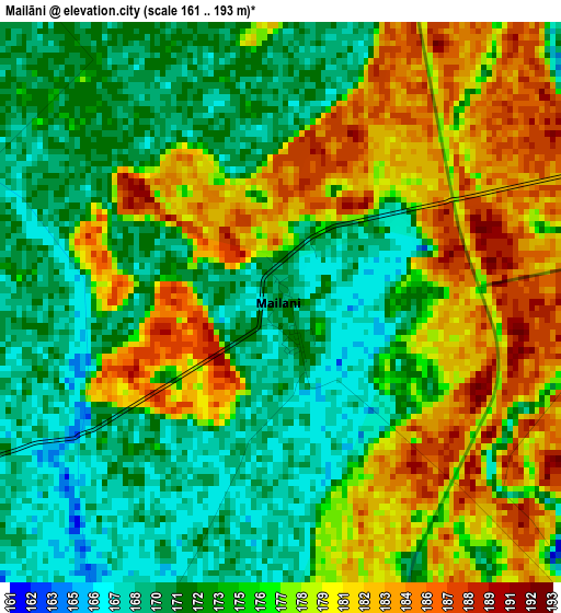
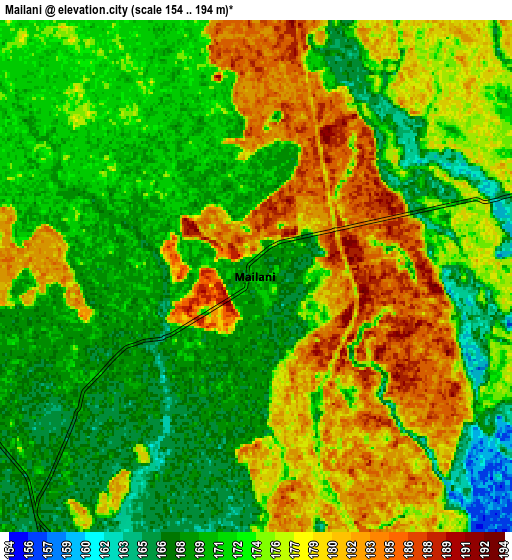
Below is the Elevation map of Mailāni, which displays elevation range with different colors. Scale of the first map is from 161 to 193 m (528 to 633 ft) with average elevation of 175.5 meters (=576 ft) [note 1]
These maps also provides idea of topography and contour of this city, they are displayed at different zoom levels. More info about maps, scale and edge coordinates you can find below images.
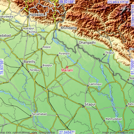
| \ | Map #1 | Map #2 | Topo.Map |
| Scale [m] | 161..193 m | 154..194 m | × |
| Scale [ft] | 528..633 ft | 505..636 ft | × |
| Average | 175.5 m = 576 ft | 174 m = 571 ft | × |
| Width | 8.61 km = 5.3 mi | 17.21 km = 10.7 mi | 275.4 km = 171.1 mi |
| Height | 8.61 km = 5.3 mi | 17.21 km = 10.7 mi | 275.4 km = 171.1 mi |
| ↑Max Latitude | 28.329569° | 28.368244° | 29.52189° |
| Latitude at center | 28.29088° | 28.29088° | 28.29088° |
| ↓Min Latitude | 28.252177° | 28.21346° | 27.04547° |
| ← Min Longitude | 80.299855° | 80.255909° | 78.93755° |
| Longitude center | 80.3438° | 80.3438° | 80.3438° |
| →Max Longitude | 80.387745° | 80.431691° | 81.75005° |
Nearby cities:
Cities around Mailāni sort by population:
• Lakhīmpur elevation 152 m
57.2 km,  131°
131°
• Bīsalpur 172 m
52.8 km,  270°
270°
• Gola Gokarannāth 164 m
26.7 km,  152°
152°
• Pūranpur 186 m
31.2 km,  322°
322°
• Paliā Kalān 162 m
28 km,  55°
55°
• Kheri 149 m
61.9 km, 134°
• Pawāyan 168 m
34.4 km,  223°
223°
• Khūtār 167 m
12.1 km, 216°
• Bilsanda 171 m
38.8 km,  262°
262°
• Barkhera Kalān 181 m
55.5 km,  288°
288°
• Kālīnagar 191 m
44.7 km, 324°
• Mohanpur 171 m
10.6 km,  246°
246°
Multilingual:
 En español:
Mailāni elevación 169 m.
 En France:
Mailāni élévation 169 m.


Sources and notes:
- [note 1] Map square and city borders are not equal. Map elevation data is calculated only from area inside that square.
- [src 1] Elevation data from geonames database provided with same terms of usage.
- [src 2] The elevation map of Mailāni is generated using elevation data from NASA's 3 arcsec (90m) resolution SRTM data.
- [src 3] Base (background) map © OpenStreetMap contributors tiles are generated by Geofabrik and OpenTopoMap.
Copyright & License:
This Mailāni Elevation Map is licensed under CC BY-SA. You may reuse any part from this page, if you give a proper credit by linking to this URL:
 More info on terms of use page.