Maināguri elevation
Maināguri (West Bengal, Jalpāiguri), India elevation is 89 meters and Maināguri elevation in feet is 292 ft above sea level [src 1]. Maināguri is a populated place (feature code) with elevation that is 204 meters (669 ft) smaller than average city elevation in India.
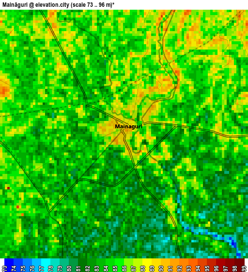
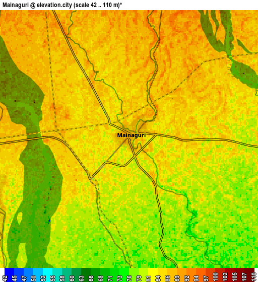
Below is the Elevation map of Maināguri, which displays elevation range with different colors. Scale of the first map is from 73 to 96 m (240 to 315 ft) with average elevation of 84.1 meters (=276 ft) [note 1]
These maps also provides idea of topography and contour of this city, they are displayed at different zoom levels. More info about maps, scale and edge coordinates you can find below images.
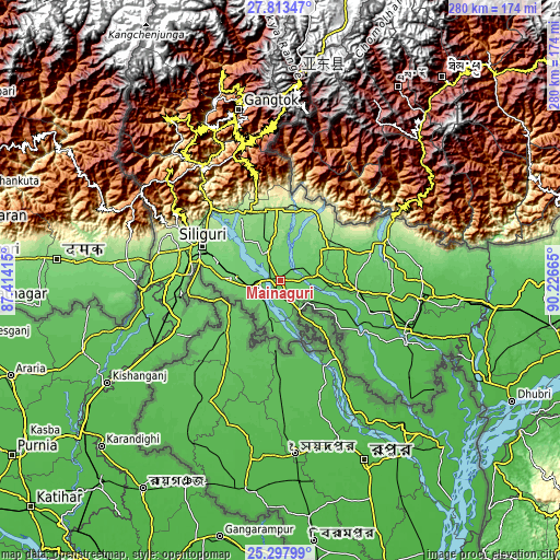
| \ | Map #1 | Map #2 | Topo.Map |
| Scale [m] | 73..96 m | 42..110 m | × |
| Scale [ft] | 240..315 ft | 138..361 ft | × |
| Average | 84.1 m = 276 ft | 83.6 m = 274 ft | × |
| Width | 8.74 km = 5.4 mi | 17.48 km = 10.9 mi | 279.7 km = 173.8 mi |
| Height | 8.74 km = 5.4 mi | 17.48 km = 10.9 mi | 279.7 km = 173.8 mi |
| ↑Max Latitude | 26.60193° | 26.641216° | 27.81347° |
| Latitude at center | 26.56263° | 26.56263° | 26.56263° |
| ↓Min Latitude | 26.523317° | 26.48399° | 25.29799° |
| ← Min Longitude | 88.776455° | 88.732509° | 87.41415° |
| Longitude center | 88.8204° | 88.8204° | 88.8204° |
| →Max Longitude | 88.864345° | 88.908291° | 90.22665° |
Nearby cities:
Cities around Maināguri sort by population:
• Siliguri elevation 124 m
42.3 km,  292°
292°
• Jalpāiguri 87 m
10.1 km,  239°
239°
• Goyerkāta 104 m
25.5 km,  53°
53°
• Naksalbāri 165 m
61.2 km,  282°
282°
• Dhupgāri 82 m
18.8 km,  81°
81°
• Hāsimāra 139 m
56.8 km,  68°
68°
• Birpara 110 m
35.9 km,  64°
64°
• Mātābhānga 56 m
46.4 km,  121°
121°
• Fālākāta 66 m
38.5 km,  97°
97°
• Bagdogra 149 m
52.8 km, 286°
• Haldībāri 76 m
25.2 km,  188°
188°
• Odlābāri 147 m
35.9 km,  328°
328°
Multilingual:
 En español:
Maināguri elevación 89 m.
 En France:
Maināguri élévation 89 m.
 Auf Deutsch:
Maināguri höhe über dem Meeresspiegel ist 89 m.

Sources and notes:
- [note 1] Map square and city borders are not equal. Map elevation data is calculated only from area inside that square.
- [src 1] Elevation data from geonames database provided with same terms of usage.
- [src 2] The elevation map of Maināguri is generated using elevation data from NASA's 3 arcsec (90m) resolution SRTM data.
- [src 3] Base (background) map © OpenStreetMap contributors tiles are generated by Geofabrik and OpenTopoMap.
Copyright & License:
This Maināguri Elevation Map is licensed under CC BY-SA. You may reuse any part from this page, if you give a proper credit by linking to this URL:
 More info on terms of use page.