Manjēshvar elevation
Manjēshvar (Kerala, Kāsaragod District), India elevation is 11 meters and Manjēshvar elevation in feet is 36 ft above sea level [src 1]. Manjēshvar is a populated place (feature code) with elevation that is 282 meters (925 ft) smaller than average city elevation in India.
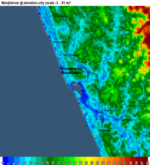
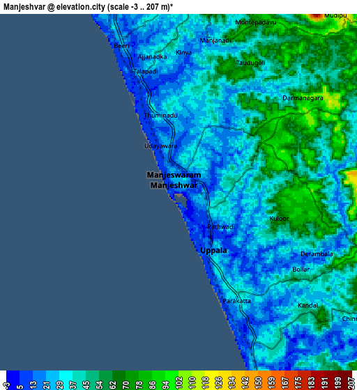
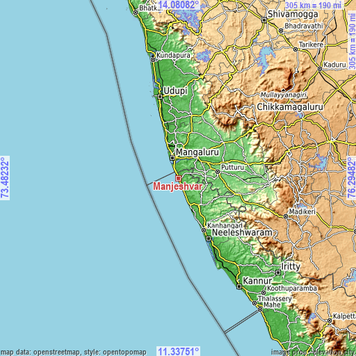
Below is the Elevation map of Manjēshvar, which displays elevation range with different colors. Scale of the first map is from -3 to 91 m (-10 to 299 ft) with average elevation of 25 meters (=82 ft) [note 1]
These maps also provides idea of topography and contour of this city, they are displayed at different zoom levels. More info about maps, scale and edge coordinates you can find below images.
| \ | Map #1 | Map #2 | Topo.Map |
| Scale [m] | -3..91 m | -3..207 m | × |
| Scale [ft] | -10..299 ft | -10..679 ft | × |
| Average | 25 m = 82 ft | 40.4 m = 133 ft | × |
| Width | 9.53 km = 5.9 mi | 19.07 km = 11.8 mi | 305 km = 189.5 mi |
| Height | 9.53 km = 5.9 mi | 19.07 km = 11.8 mi | 305.1 km = 189.6 mi |
| ↑Max Latitude | 12.755734° | 12.798591° | 14.08082° |
| Latitude at center | 12.71287° | 12.71287° | 12.71287° |
| ↓Min Latitude | 12.669998° | 12.62712° | 11.33751° |
| ← Min Longitude | 74.844625° | 74.800679° | 73.48232° |
| Longitude center | 74.88857° | 74.88857° | 74.88857° |
| →Max Longitude | 74.932515° | 74.976461° | 76.29482° |
Nearby cities:
Cities around Manjēshvar sort by population:
• Mangalore elevation 27 m
23 km,  351°
351°
• Kānnangād 19 m
50.8 km,  152°
152°
• Ullal 18 m
10.8 km,  343°
343°
• Puttūr 100 m
34.4 km,  81°
81°
• Kāsaragod 43 m
26.2 km,  155°
155°
• Bantvāl 26 m
25.3 km,  38°
38°
• Mūdbidri 130 m
41 km,  16°
16°
• Nīlēshwar 15 m
57.1 km, 152°
• Kārkala 93 m
56.9 km,  11°
11°
• Sulya 119 m
56.7 km,  107°
107°
• Mūlki 26 m
43.3 km, 346°
• Pāngāla 15 m
61.6 km, 345°
Multilingual:
 En español:
Manjēshvar elevación 11 m.
 En France:
Manjēshvar élévation 11 m.
 Auf Deutsch:
Manjēshvar höhe über dem Meeresspiegel ist 11 m.

Sources and notes:
- [note 1] Map square and city borders are not equal. Map elevation data is calculated only from area inside that square.
- [src 1] Elevation data from geonames database provided with same terms of usage.
- [src 2] The elevation map of Manjēshvar is generated using elevation data from NASA's 3 arcsec (90m) resolution SRTM data.
- [src 3] Base (background) map © OpenStreetMap contributors tiles are generated by Geofabrik and OpenTopoMap.
Copyright & License:
This Manjēshvar Elevation Map is licensed under CC BY-SA. You may reuse any part from this page, if you give a proper credit by linking to this URL:
 More info on terms of use page.