Sulya elevation
Sulya (Karnataka, Dakshina Kannada), India elevation is 119 meters and Sulya elevation in feet is 390 ft above sea level [src 1]. Sulya is a populated place (feature code) with elevation that is 174 meters (571 ft) smaller than average city elevation in India.
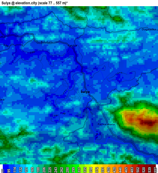
Below is the Elevation map of Sulya, which displays elevation range with different colors. Scale of the first map is from 77 to 557 m (253 to 1827 ft) with average elevation of 142.9 meters (=469 ft) [note 1]
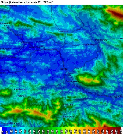
These maps also provides idea of topography and contour of this city, they are displayed at different zoom levels. More info about maps, scale and edge coordinates you can find below images.
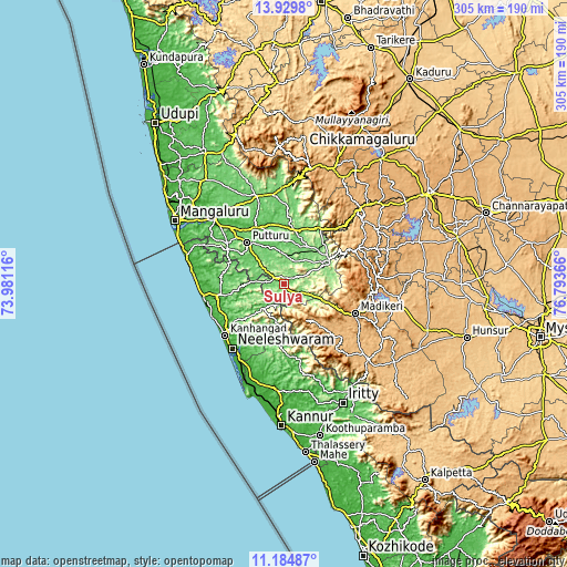
| \ | Map #1 | Map #2 | Topo.Map |
| Scale [m] | 77..557 m | 72..722 m | × |
| Scale [ft] | 253..1827 ft | 236..2369 ft | × |
| Average | 142.9 m = 469 ft | 190.6 m = 625 ft | × |
| Width | 9.54 km = 5.9 mi | 19.08 km = 11.9 mi | 305.2 km = 189.6 mi |
| Height | 9.54 km = 5.9 mi | 19.08 km = 11.9 mi | 305.2 km = 189.6 mi |
| ↑Max Latitude | 12.60389° | 12.646773° | 13.9298° |
| Latitude at center | 12.561° | 12.561° | 12.561° |
| ↓Min Latitude | 12.518103° | 12.475199° | 11.18487° |
| ← Min Longitude | 75.343465° | 75.299519° | 73.98116° |
| Longitude center | 75.38741° | 75.38741° | 75.38741° |
| →Max Longitude | 75.431355° | 75.475301° | 76.79366° |
Nearby cities:
Cities around Sulya sort by population:
• Payyannūr elevation 11 m
55.7 km,  201°
201°
• Talipparamba 45 m
57.8 km,  183°
183°
• Kānnangād 19 m
41.5 km,  227°
227°
• Puttūr 100 m
29.9 km,  317°
317°
• Kāsaragod 43 m
43.7 km,  260°
260°
• Bantvāl 26 m
53 km,  313°
313°
• Madikeri 1141 m
40.9 km,  111°
111°
• Nīlēshwar 15 m
43.3 km,  219°
219°
• Manjēshvar 11 m
56.7 km,  287°
287°
• Somvārpet 1133 m
50.3 km,  85°
85°
• Sanivārsante 960 m
57.3 km,  71°
71°
• Suntikoppa 969 m
49.4 km,  103°
103°
Multilingual:
 En español:
Sulya elevación 119 m.
 En France:
Sulya élévation 119 m.


Sources and notes:
- [note 1] Map square and city borders are not equal. Map elevation data is calculated only from area inside that square.
- [src 1] Elevation data from geonames database provided with same terms of usage.
- [src 2] The elevation map of Sulya is generated using elevation data from NASA's 3 arcsec (90m) resolution SRTM data.
- [src 3] Base (background) map © OpenStreetMap contributors tiles are generated by Geofabrik and OpenTopoMap.
Copyright & License:
This Sulya Elevation Map is licensed under CC BY-SA. You may reuse any part from this page, if you give a proper credit by linking to this URL:
 More info on terms of use page.