Nirmal elevation
Nirmal (Telangana), India elevation is 338 meters and Nirmal elevation in feet is 1109 ft above sea level [src 1]. Nirmal is a seat of a second-order administrative division (feature code) with elevation that is 45 meters (148 ft) bigger than average city elevation in India.
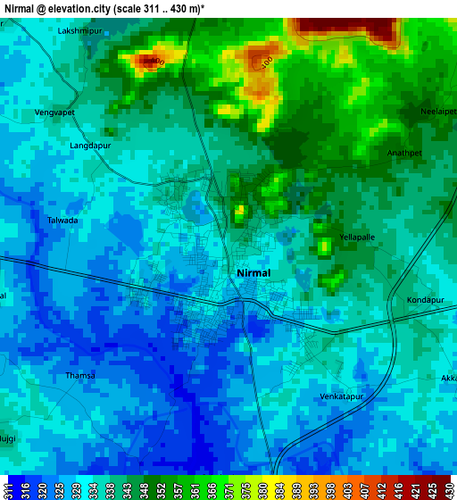
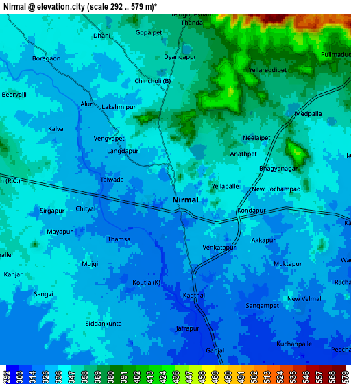
Below is the Elevation map of Nirmal, which displays elevation range with different colors. Scale of the first map is from 311 to 430 m (1020 to 1411 ft) with average elevation of 337.9 meters (=1109 ft) [note 1]
These maps also provides idea of topography and contour of this city, they are displayed at different zoom levels. More info about maps, scale and edge coordinates you can find below images.
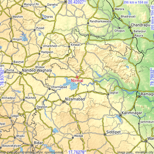
| \ | Map #1 | Map #2 | Topo.Map |
| Scale [m] | 311..430 m | 292..579 m | × |
| Scale [ft] | 1020..1411 ft | 958..1900 ft | × |
| Average | 337.9 m = 1109 ft | 343.8 m = 1128 ft | × |
| Width | 9.23 km = 5.7 mi | 18.47 km = 11.5 mi | 295.5 km = 183.6 mi |
| Height | 9.23 km = 5.7 mi | 18.47 km = 11.5 mi | 295.5 km = 183.6 mi |
| ↑Max Latitude | 19.138372° | 19.179883° | 20.42027° |
| Latitude at center | 19.09685° | 19.09685° | 19.09685° |
| ↓Min Latitude | 19.055318° | 19.013775° | 17.76276° |
| ← Min Longitude | 78.300125° | 78.256179° | 76.93782° |
| Longitude center | 78.34407° | 78.34407° | 78.34407° |
| →Max Longitude | 78.388015° | 78.431961° | 79.75032° |
Nearby cities:
Cities around Nirmal sort by population:
• Nizāmābād elevation 389 m
53.9 km,  208°
208°
• Ādilābād 257 m
67 km,  17°
17°
• Jagtiāl 282 m
68.9 km,  119°
119°
• Bodhan 375 m
68.3 km,  224°
224°
• Koratla 301 m
49.3 km,  128°
128°
• Bhaisa 369 m
40 km,  272°
272°
• Kyathampalle 262 m
66.4 km, 16°
• Dharmābād 360 m
56.8 km,  246°
246°
• Kinwat 317 m
60.7 km,  345°
345°
• Dasnapur 265 m
64.4 km, 15°
• Kondalwādi 361 m
68.4 km,  241°
241°
• Biloli 371 m
74.4 km, 241°
Multilingual:
 En español:
Nirmal elevación 338 m.
 En France:
Nirmal élévation 338 m.


Sources and notes:
- [note 1] Map square and city borders are not equal. Map elevation data is calculated only from area inside that square.
- [src 1] Elevation data from geonames database provided with same terms of usage.
- [src 2] The elevation map of Nirmal is generated using elevation data from NASA's 3 arcsec (90m) resolution SRTM data.
- [src 3] Base (background) map © OpenStreetMap contributors tiles are generated by Geofabrik and OpenTopoMap.
Copyright & License:
This Nirmal Elevation Map is licensed under CC BY-SA. You may reuse any part from this page, if you give a proper credit by linking to this URL:
 More info on terms of use page.